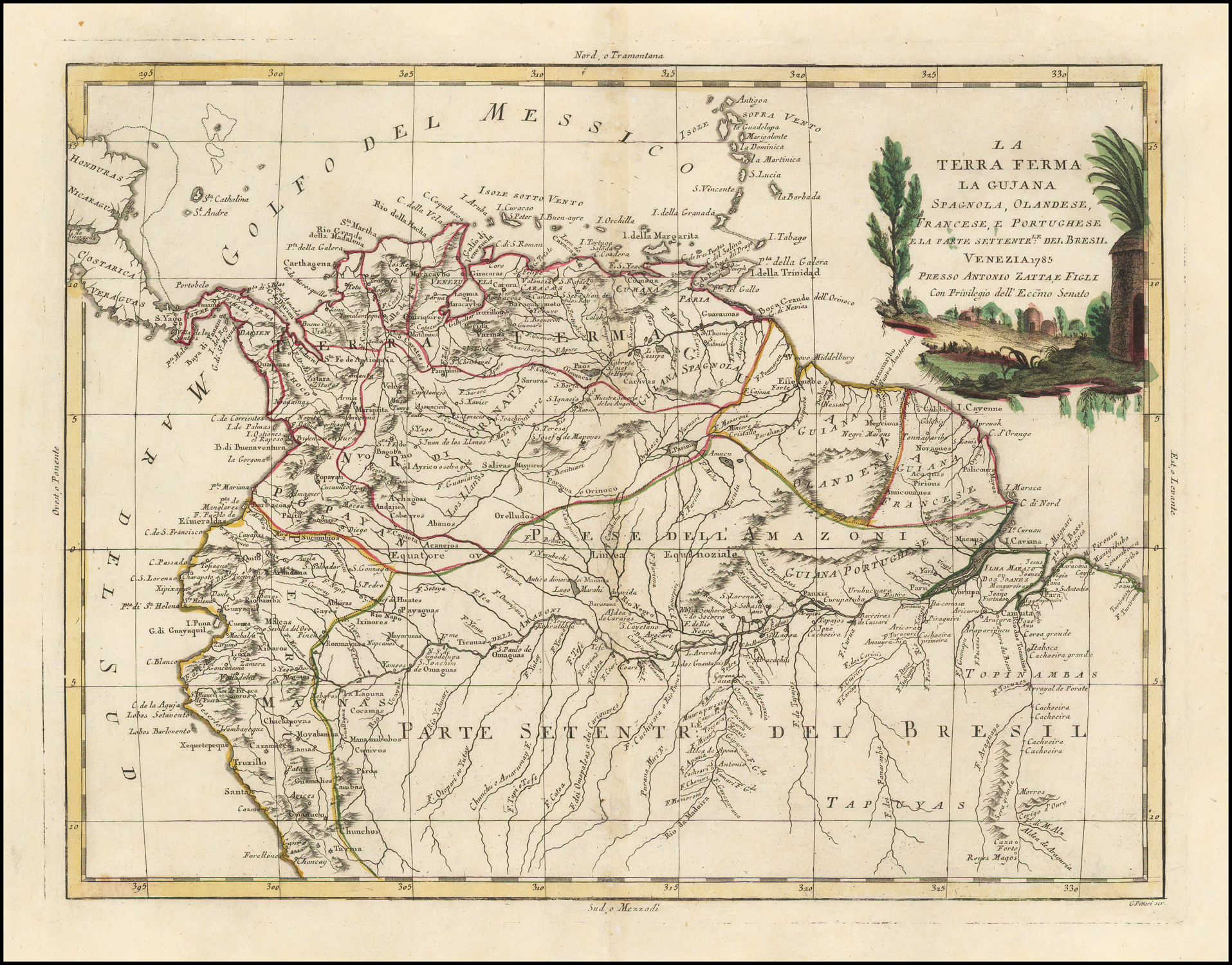
Dispossesions in the Americas

Dispossesions in the Americas

  • Home
  • Explore
  • About
  • Authors
  • Art
  • Bodies
  • Curricula
  • Cultural Heritage
  • Maps
  • Territories
Back to Explore
Map 1785

LA TERRA FERMA LA GUJANA Spagnola;Olandese;Frances;E. Portughese E La Parte Settentr le Del Bresil

  • ZATTA;ANTONIO

Published: 1785

  • Download Image

Peoples

  • GIRACARAS
  • QUAQUAAS
  • URABA
  • ZITARA
  • QUIRIQUIRES
  • MOTILONES
  • CARATES
  • SATURAS
  • OTOMACAS
  • PAOS
  • CARIVAS
  • GUARAUNAS
  • GALIBIS
  • PALICOURS
  • NORAGUES
  • PIRIOUS
  • ACOQUAS
  • AMICOUANES
  • MERCIOUS
  • ORELLUDOS
  • SALIVAS
  • MAYPURES
  • ACANEJOS
  • ABANOS
  • CABERRES
  • ANDAJIES
  • ACHAGUAS
  • SUCUMBIOS
  • XIBAROS
  • GAYES
  • IXINORES
  • MAYORUNAS
  • ROAMAYNAS
  • HUATES
  • PAYAGUAS
  • OMAGUAS
  • TICUNAS
  • PAUXIS
  • PARU
  • CORUPA
  • TAPUYAS
  • COCAMAS
  • MANAMABOBOC
  • CUNIVOS
  • PIROS
  • CAMBAS
  • GUAMALIES
  • CHUNCHOS

Citation

Zatta, Antonio. La Terra Ferma La Gujana Spagnola, Olandese, Frances, E. Portughese E La Parte Settente.le Del Bresil. Map. Venice, 1785. Accessed August 28, 2022. https://www.raremaps.com/gallery/detail/44586/la-terra-ferma-la-gujana-spagnola-olandese-frances-e-por-zatta.

  • Download Image

Reading in Spanish

Map 1785

LA TERRA FERMA LA GUJANA Spagnola;Olandese;Frances;E. Portughese E La Parte Settentr le Del Bresil

  • ZATTA;ANTONIO

Published: 1785

  • Download Image
  • Download Image

Related Content

Ishir (Chamacoco)

Ishir (Chamacoco)

Map 2001
MAPA Físico y Político DE LA REPÚBLICA DE VENEZUELA

MAPA Físico y Político DE LA REPÚBLICA DE VENEZUELA

Map 1840
Mapa IX.1 Familias y lenguas indígenas del Caribe Continental

Mapa IX.1 Familias y lenguas indígenas del Caribe Continental

Map 2009
Carte de la Guiane

Carte de la Guiane

Map 1700 - 1799
COLUMBIA

COLUMBIA

Map 1829
REGIÓN MAYO-YAQUI

REGIÓN MAYO-YAQUI

Map 2000
Mapa geográfico de la mayor parte de la América Meridional que contiene los paises por donde debe trazarse la línia divisoria que divida los dominios de España y Portugal: construido en virtud de real órden por el teniente general Dn. Francisco Requena

Mapa geográfico de la mayor parte de la América Meridional que contiene los paises por donde debe trazarse la línia divisoria que divida los dominios de España y Portugal: construido en virtud de real órden por el teniente general Dn. Francisco Requena

Map 1796
DURANGO

DURANGO

Map 2015

Dispossessions in the Americas

A project by

University of Pennsylvania

Copyright 2024

With support from

Mellon Foundation

Site design & development

Element 84

Art Credits

Zatta, Antonio. La Terra Ferma La Gujana Spagnola, Olandese, Frances, E. Portughese E La Parte Settente.le Del Bresil. Map. Venice, 1785. Accessed August 28, 2022. https://www.raremaps.com/gallery/detail/44586/la-terra-ferma-la-gujana-spagnola-olandese-frances-e-por-zatta.

Site Pages

  • Home
  • Explore
  • About
  • Authors
  • Art
  • Bodies
  • Curricula
  • Cultural Heritage
  • Maps
  • Territories