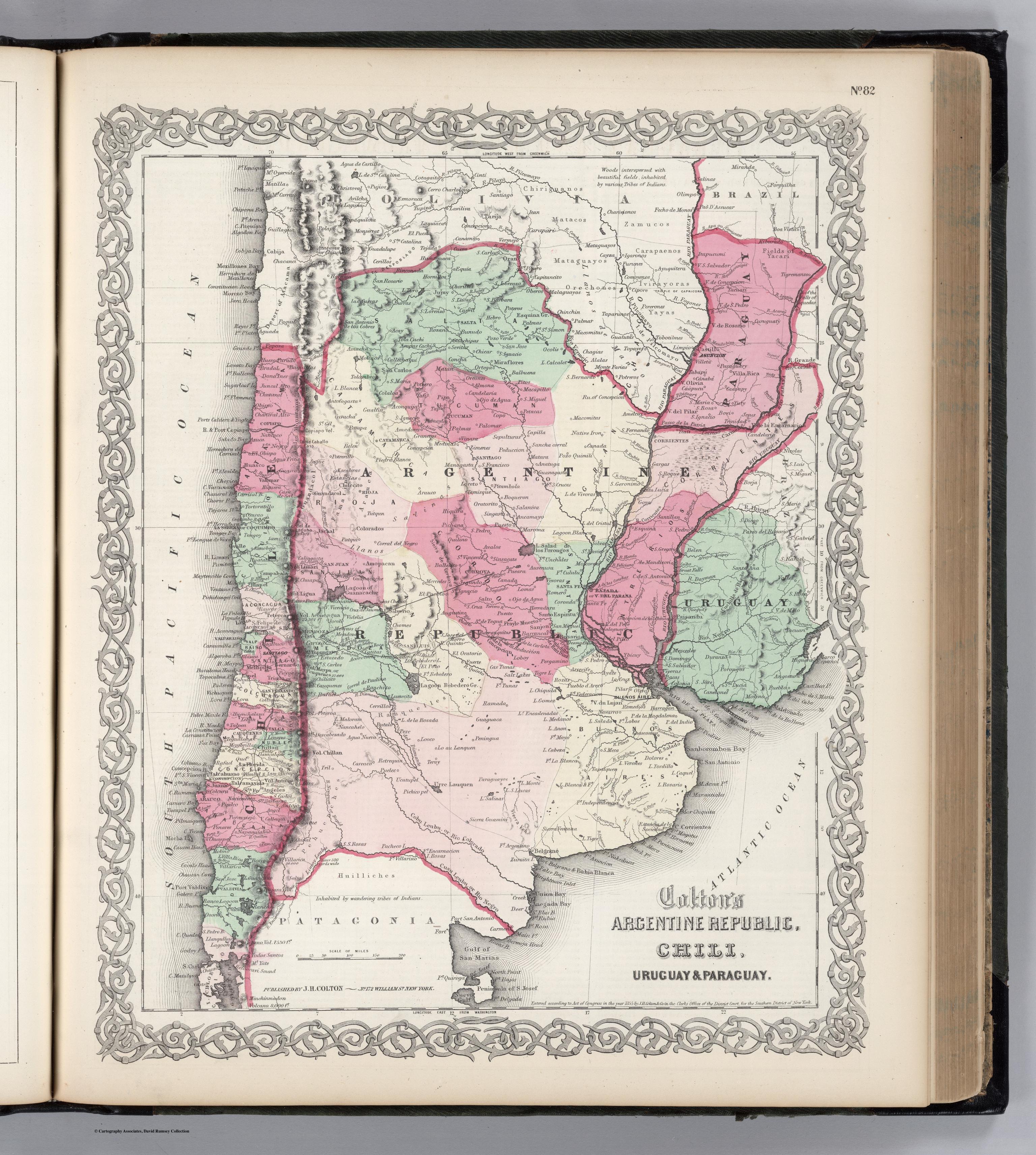
Dispossesions in the Americas

Dispossesions in the Americas

  • Home
  • Explore
  • About
  • Authors
  • Art
  • Bodies
  • Curricula
  • Cultural Heritage
  • Maps
  • Territories
Back to Explore
Map 1855

Colton's ARG Republic;Chili;Uruguay & Paraguay

  • COLTON;G. W.

Published: 1865

  • Download Image

Peoples

  • CHIRIGUANOS
  • MATACOS
  • MATAGUAYOS
  • ORECHONES
  • CAMUCOS
  • CARAPAENOS
  • IVIRAYORAS
  • YAYAS
  • RANQUELLES
  • HUILLICHES
  • PEHUENCHES

Citation

Colton, G. W. Colton's Argentina Republic, Chili, Uruguay & Paraguay. Map. New York: J. H. Colton, 1865. Accessed April 29, 2022. https://www.davidrumsey.com/luna/servlet/detail/RUMSEY~8~1~208773~5003454:ARG-Republic,-CHI,-URU-?sort=pub_list_no_initialsort%2Cpub_list_no_initialsort%2Cpub_date%2Cpub_date&qvq=w4s:/where%2FURU,sort:pub_list_no_initialsort%2Cpub_list_no_initialsort%2Cpub_date%2Cpub_date,lc:RUMSEY~8~1&mi=6&trs=88.

  • Download Image

Reading in Spanish

Map 1855

Colton's ARG Republic;Chili;Uruguay & Paraguay

  • COLTON;G. W.

Published: 1865

  • Download Image
  • Download Image

Related Content

Departamentos y municipios de mayor concentración del pueblo Awá

Departamentos y municipios de mayor concentración del pueblo Awá

Map 2005
Descripción de las Provincias del Chaco, y/confindantes
     según las relaciones modernas

Descripción de las Provincias del Chaco, y/confindantes según las relaciones modernas

Map 1700
CARTE DU PEROU DU FLEUVE DES AMAZONES ET DU BRESIL

CARTE DU PEROU DU FLEUVE DES AMAZONES ET DU BRESIL

Map 1700 - 1799
PUEBLO CHONTAL DE TABASCO

PUEBLO CHONTAL DE TABASCO

Map 2020
Government map of Nicaragua : from the latest surveys ordered by President Patricio Rivas and Genl. William Walker ;executed under the supervision of the Señor Fermín Ferrer;Governor of the Western Department;1856

Government map of Nicaragua : from the latest surveys ordered by President Patricio Rivas and Genl. William Walker ;executed under the supervision of the Señor Fermín Ferrer;Governor of the Western Department;1856

Map 1800 - 1856
PROVINCIA DE SAPUCAHY

PROVINCIA DE SAPUCAHY

Map 1873
Mapa histórico-geográfico de Perú, Chile y Buenos Aires

Mapa histórico-geográfico de Perú, Chile y Buenos Aires

Map 1830
Parte de la América Meridional

Parte de la América Meridional

Map 1764 - 1767

Dispossessions in the Americas

A project by

University of Pennsylvania

Copyright 2024

With support from

Mellon Foundation

Site design & development

Element 84

Art Credits

Colton, G. W. Colton’s Argentina Republic, Chili, Uruguay & Paraguay. Map. New York: J. H. Colton, 1865. Accessed April 29, 2022. https://www.davidrumsey.com/luna/servlet/detail/RUMSEY~8~1~208773~5003454:ARG-Republic,-CHI,-URU-?sort=pub_list_no_initialsort%2Cpub_list_no_initialsort%2Cpub_date%2Cpub_date&qvq=w4s:/where%2FURU,sort:pub_list_no_initialsort%2Cpub_list_no_initialsort%2Cpub_date%2Cpub_date,lc:RUMSEY~8~1&mi=6&trs=88.

Site Pages

  • Home
  • Explore
  • About
  • Authors
  • Art
  • Bodies
  • Curricula
  • Cultural Heritage
  • Maps
  • Territories