Dispossesions in the Americas

Dispossesions in the Americas

  • Home
  • Explore
  • About
  • Authors
  • Art
  • Bodies
  • Curricula
  • Cultural Heritage
  • Maps
  • Territories
Back to Explore
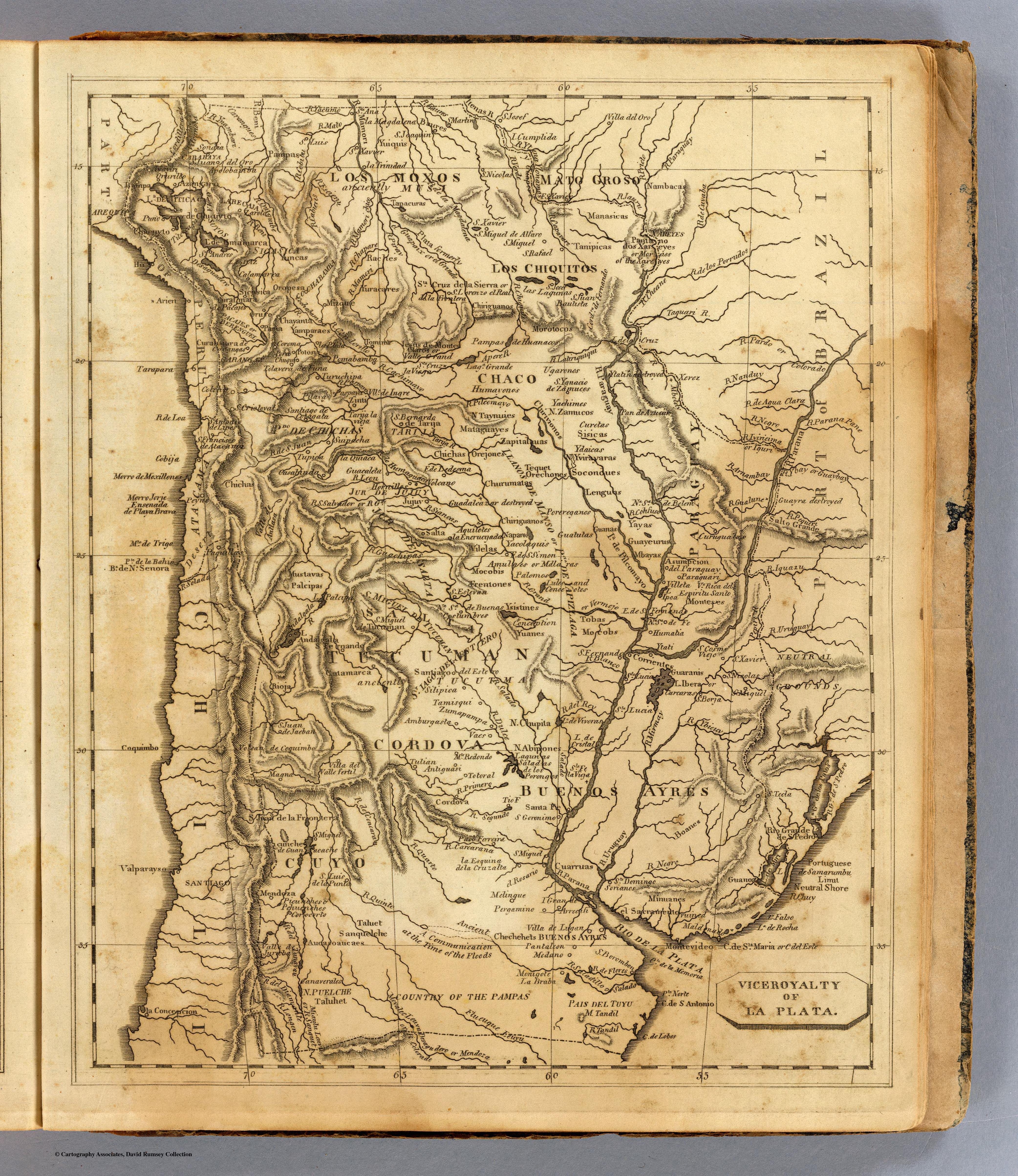
Map 1812

Viceroyalty of La Plata

  • ARROWSMITH;AARON;ET AL.

Published: 1812

  • Download Image

Peoples

  • PAMPAS
  • YUIQUIS
  • NAMBACAS
  • MANASICAS
  • TANIPICAS
  • MOROTOCOS
  • CHIRIGUANOS
  • OREJONES
  • LENGUAS
  • MBAYAS
  • TOBAS
  • GUARANIS
  • YTATI
  • MOCOBIS
  • MATAGUAYES
  • UGARONOS
  • ZAMUCOS
  • YACHIMES
  • CHIRIVIONOS
  • ORECHONES
  • TEQUET
  • CHURUMATAS
  • NAPAROS
  • VILELAS
  • AQUILOTES
  • SOCONDUES
  • POREREGANOS
  • GUATUTAS
  • GUANAS
  • YAYAS
  • CARCARAS
  • MOCOBS
  • LULES
  • CONOEOTES
  • GUAYEURUS
  • CAPITALAUAS
  • YACOLAQUIS
  • CURETAS
  • SISICAS
  • YDAICAS
  • YVIRAYARAS
  • RACHES
  • YURACARES
  • YUNCAS
  • OROPESA
  • MOXOS
  • CHIQUITOS
  • CHICHAS
  • HUMAYONOS
  • TAYNUIES
  • FRENTONES
  • YSISTINES
  • TUANES
  • ABIPONES
  • CHIPITA
  • PALOMOS
  • CATAMARCA
  • PALCIPAS
  • MUSTAVAS
  • TALUET
  • TALUHET
  • PUELCHE
  • SANQUELCHE
  • AUCASOAUCAES
  • PICUNCHES
  • PEHUENCHES
  • CHECHEHETS
  • CUARRUAS
  • MINUANES
  • BOANES
  • GUANOA

Citation

Arrowsmith, Aaron. Viceroyalty of La Plata. Map. Boston: Thomas & Andrews, 1812. Accessed April 24, 2022. https://www.davidrumsey.com/luna/servlet/detail/RUMSEY~8~1~31723~1150518:La-Plata-?qvq=w4s%3A%2Fwhere%2FURU%3Bsort%3Apub_list_no_initialsort%2Cpub_list_no_initialsort%2Cpub_date%2Cpub_date%3Blc%3ARUMSEY%7E8%7E1&mi=4&trs=88.
  • Download Image

Reading in Spanish

Map 1812

Viceroyalty of La Plata

  • ARROWSMITH;AARON;ET AL.

Published: 1812

  • Download Image
  • Download Image

Related Content

Principales grupos indígenas cuando ocurrió el contacto con los españoles

Principales grupos indígenas cuando ocurrió el contacto con los españoles

Map 1530
MULTI-ETHNIC TERRITORY under INCA DIRECT RULE: THE LOWER VALLEY OF COCHABAMBA in the 1530s

MULTI-ETHNIC TERRITORY under INCA DIRECT RULE: THE LOWER VALLEY OF COCHABAMBA in the 1530s

Map 1520
Carte Physique et Politique de l'Amérique Méridionale.

Carte Physique et Politique de l'Amérique Méridionale.

Map 1800 - 1899
Map of El Salvador with Specific indigenous communities in El Salvador, and the archaeological zone of Chalchuapa in western El Salvador. The Department of San Vicente is also highlighted.

Map of El Salvador with Specific indigenous communities in El Salvador, and the archaeological zone of Chalchuapa in western El Salvador. The Department of San Vicente is also highlighted.

Map 2010
Localización de los pueblos urus

Localización de los pueblos urus

Map 2014
CHILE LA PLATA AND URUGUAY

CHILE LA PLATA AND URUGUAY

Map 1836
A New Map of Mexico and Adjacent Provinces Compiled From Original Documents

A New Map of Mexico and Adjacent Provinces Compiled From Original Documents

Map 1810
Mapa particular del Golfo e Ystmo del Darien ocupados por la mayor parte de los indios gentiles enemigos crueles y alevosos de la Nacion española quanto amigos dela inglesa : para la inteligencia de los ataques que conviene hacerlos para su reducion o aniquilacion

Mapa particular del Golfo e Ystmo del Darien ocupados por la mayor parte de los indios gentiles enemigos crueles y alevosos de la Nacion española quanto amigos dela inglesa : para la inteligencia de los ataques que conviene hacerlos para su reducion o aniquilacion

Map 1700 - 1799

Dispossessions in the Americas

A project by

University of Pennsylvania

Copyright 2024

With support from

Mellon Foundation

Site design & development

Element 84

Art Credits

Arrowsmith, Aaron. Viceroyalty of La Plata. Map. Boston: Thomas & Andrews, 1812. Accessed April 24, 2022. https://www.davidrumsey.com/luna/servlet/detail/RUMSEY~8~1~31723~1150518:La-Plata-?qvq=w4s%3A%2Fwhere%2FURU%3Bsort%3Apub_list_no_initialsort%2Cpub_list_no_initialsort%2Cpub_date%2Cpub_date%3Blc%3ARUMSEY%7E8%7E1&mi=4&trs=88.
Site Pages

  • Home
  • Explore
  • About
  • Authors
  • Art
  • Bodies
  • Curricula
  • Cultural Heritage
  • Maps
  • Territories