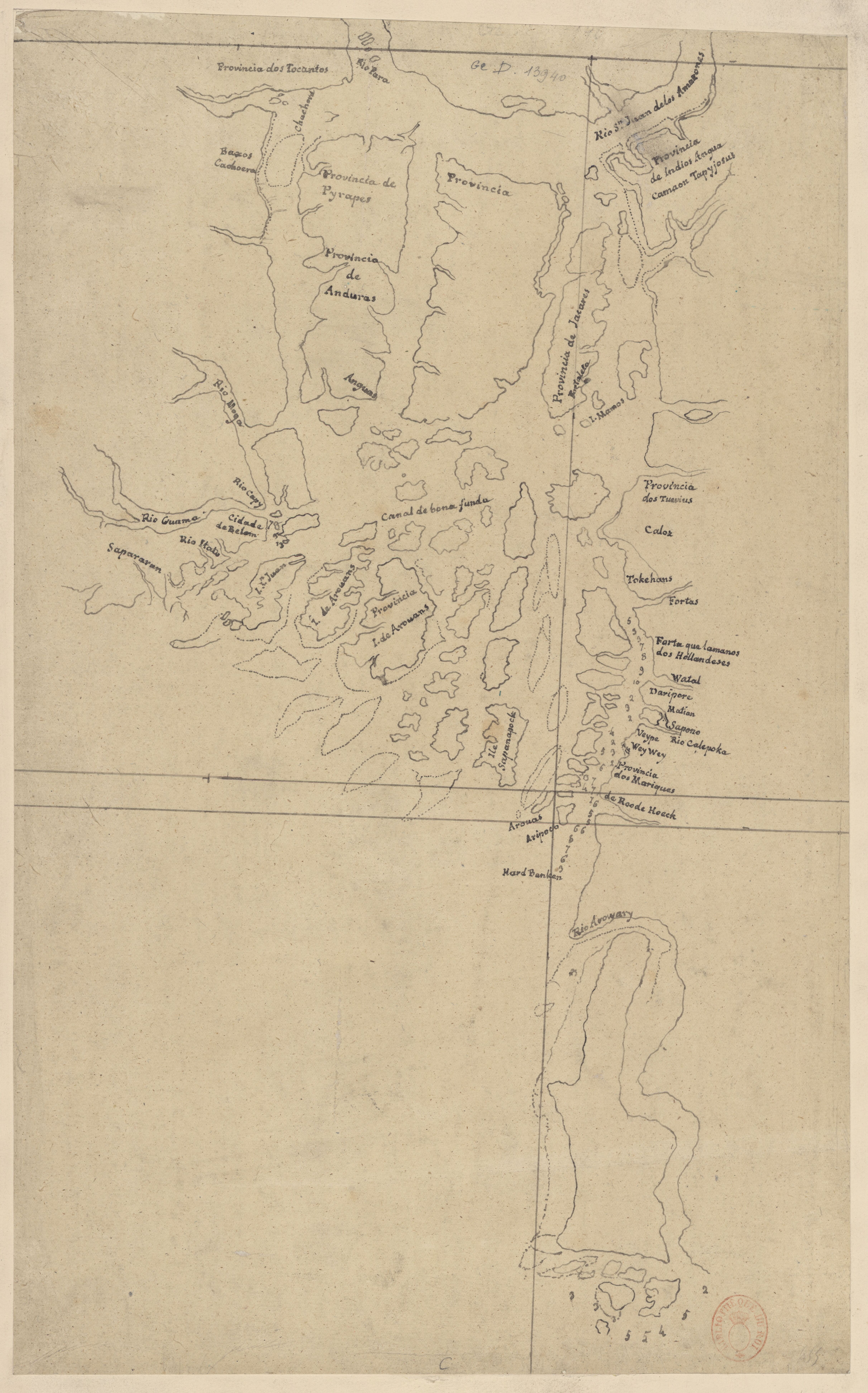
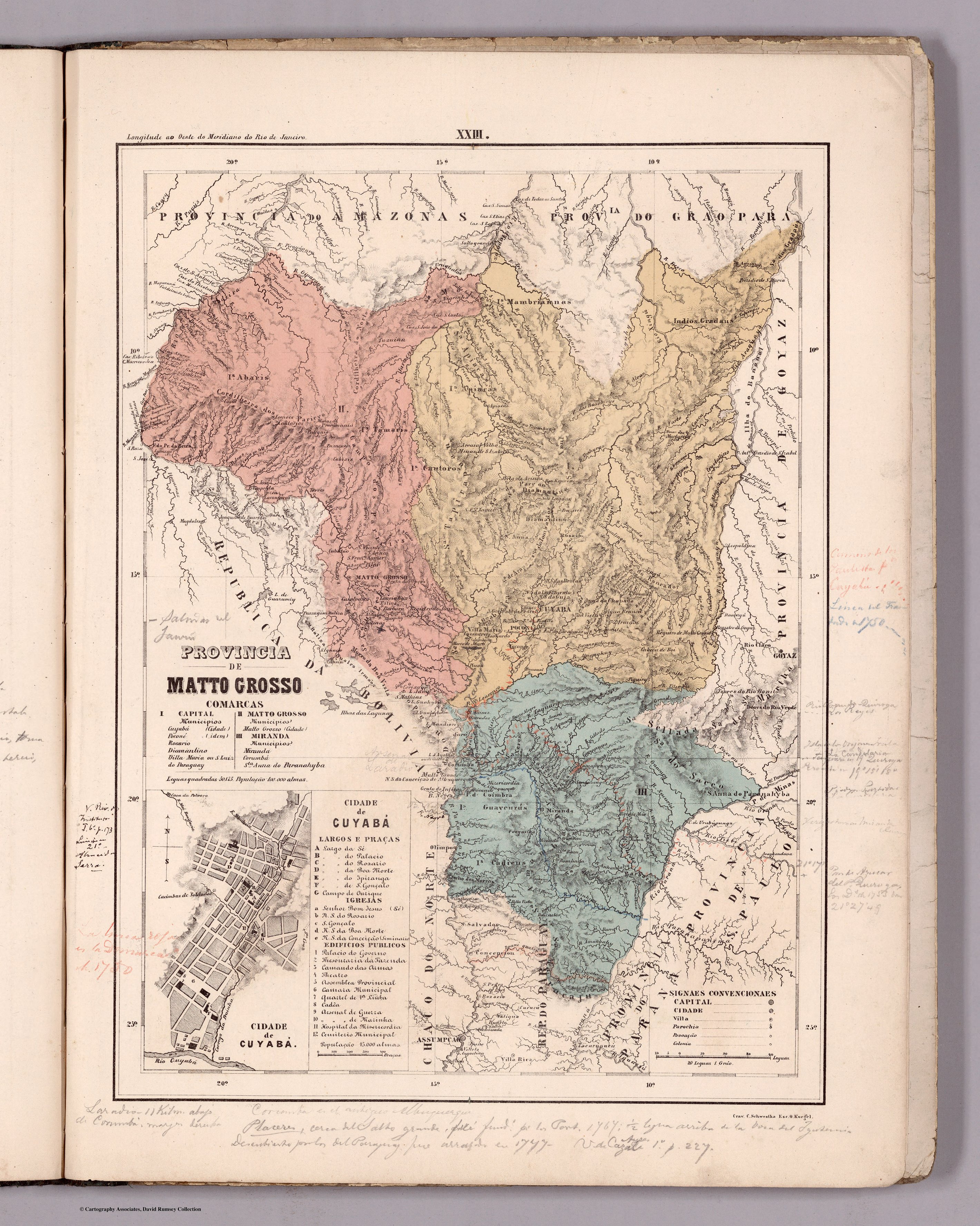
Dispossesions in the Americas

Dispossesions in the Americas

  • Home
  • Explore
  • About
  • Authors
  • Art
  • Bodies
  • Curricula
  • Cultural Heritage
  • Maps
  • Territories
Back to Explore
Map 1800 - 1850

PROVINCIA DE MATTO GROSSO

  • MENDES, CANDIDO

Published: 1868

  • Download Image

Peoples

  • GRADUS
  • MAMBRIANNAS
  • ABARIS
  • TAMARIS
  • CAUTOROS
  • APAICAS
  • GUAYCURUS
  • CADIEUS

Citation

Mendes, Candido. Provincia de Matto Grosso. Map. Rio de Janeiro: Lithographia do Instituto Philomathico, 1868. Accessed August 15, 2023. https://www.davidrumsey.com/luna/servlet/detail/RUMSEY~8~1~305768~90076419#.

  • Download Image

Reading in Spanish

Map 1800 - 1850

PROVINCIA DE MATTO GROSSO

  • MENDES, CANDIDO

Published: 1868

  • Download Image
  • Download Image

Reading in Portuguese

Map 1800 - 1850

PROVINCIA DE MATTO GROSSO

  • MENDES, CANDIDO

Published: 1868

  • Download Image

Peoples

  • GRADUS
  • MAMBRIANNAS
  • ABARIS
  • TAMARIS
  • CAUTOROS
  • APAICAS
  • GUAYCURUS
  • CADIEUS

Citation

Mendes, Candido. Provincia de Matto Grosso. Map. Rio de Janeiro: Lithographia do Instituto Philomathico, 1868. Accessed August 15, 2023. https://www.davidrumsey.com/luna/servlet/detail/RUMSEY~8~1~305768~90076419#.

  • Download Image

Related Content

Rio Para

Rio Para

Map 1700 - 1750
MAPA DE TIERRAS DE COMUNIDADES NEGRAS

MAPA DE TIERRAS DE COMUNIDADES NEGRAS

Map 2012
A New Map of Mexico and Adjacent Provinces Compiled From Original Documents

A New Map of Mexico and Adjacent Provinces Compiled From Original Documents

Map 1810
Collection of different versions of the Peru Jaguar, Peru Otorongo, and the “Perucitos”

Collection of different versions of the Peru Jaguar, Peru Otorongo, and the “Perucitos”

Artwork
PROVINCIE DELLO SPIRITO SANTO E DI PORTO SICURO

PROVINCIE DELLO SPIRITO SANTO E DI PORTO SICURO

Map 1600 - 1699
XXIV. Carte du Rio Grande de la Magdalena, depuis ses sources jusqu'a son embouchure.

XXIV. Carte du Rio Grande de la Magdalena, depuis ses sources jusqu'a son embouchure.

Map 1799 - 1804
Carte 6: Migrations des Tupi au nord de l'Amazones (XVIe et XVIIe siècles)

Carte 6: Migrations des Tupi au nord de l'Amazones (XVIe et XVIIe siècles)

Map 1500 - 1699
Tribes of Chile and Northwest Argentina

Tribes of Chile and Northwest Argentina

Map

Dispossessions in the Americas

A project by

University of Pennsylvania

Copyright 2024

With support from

Mellon Foundation

Site design & development

Element 84

Art Credits

Mendes, Candido. Provincia de Matto Grosso. Map. Rio de Janeiro: Lithographia do Instituto Philomathico, 1868. Accessed August 15, 2023. https://www.davidrumsey.com/luna/servlet/detail/RUMSEY~8~1~305768~90076419#.

Site Pages

  • Home
  • Explore
  • About
  • Authors
  • Art
  • Bodies
  • Curricula
  • Cultural Heritage
  • Maps
  • Territories