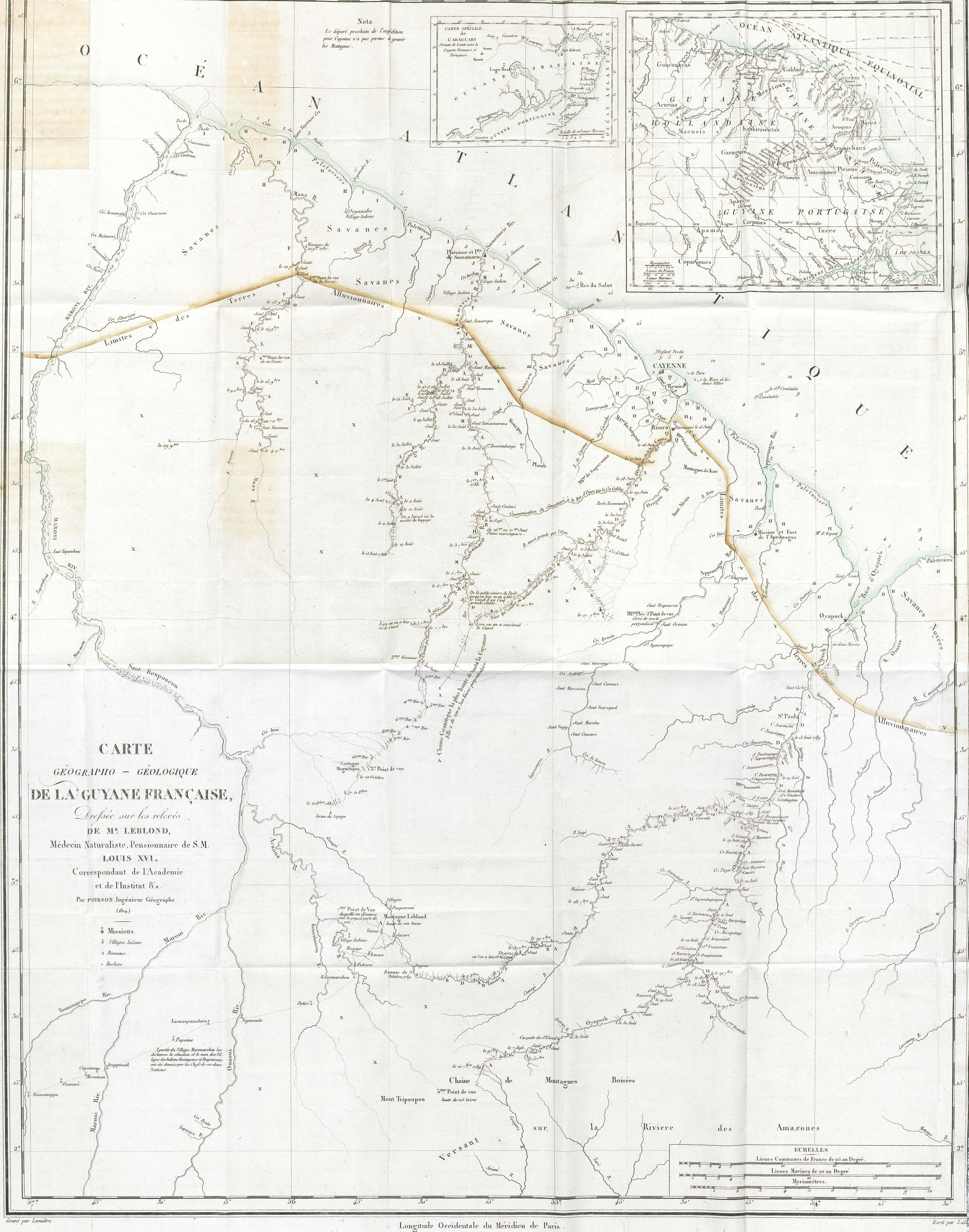
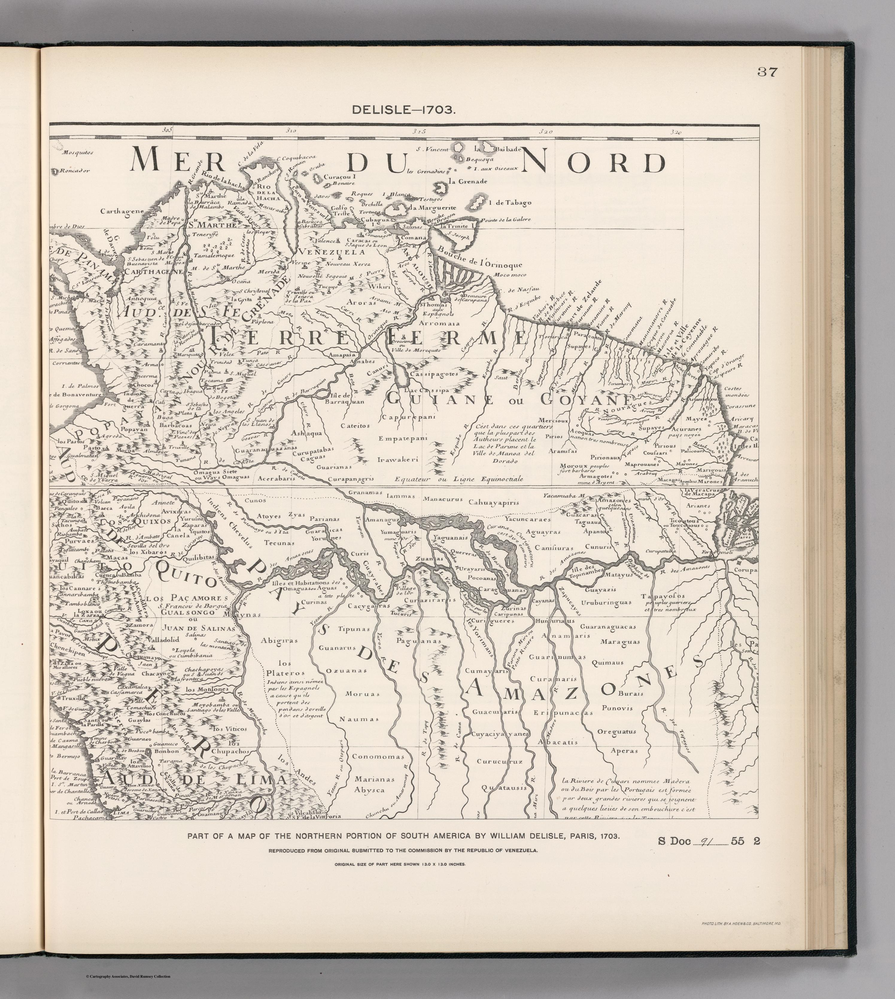
Dispossesions in the Americas

Dispossesions in the Americas

  • Home
  • Explore
  • About
  • Authors
  • Art
  • Bodies
  • Curricula
  • Cultural Heritage
  • Maps
  • Territories
Back to Explore
Map 1600 - 1750

Côtes de la Guyane brésilienne de l'Oyapoc à Para

    Published: 1750

    • Download Image

    Peoples

    • KOUROUPA
    • AROUKAKAITS
    • ANIVIANNES
    • AROUHA
    • MARAONNES
    • MAPROUANNES
    • OYANENGA
    • OURANAYOU
    • KOUSSARY
    • MAYES
    • MAYKA
    • OURAMIO
    • ITOUTANNES
    • KARANGUES
    • OUAYEMPIS
    • MAJOUANY
    • COUSSANY
    • ARAMAYON
    • KARANNES
    • KARACOYAUX
    • ALICOURA
    • PALICOURS
    • KARANARIO
    • PIRIOUX
    • OUAYES
    • TARIPI
    • OUEN
    • TOKOYENNES

    Citation

    "Côtes de la Guyane brésilienne de l'Oyapoc à Para." Map. 1750. Accessed August 12, 2023. https://gallica.bnf.fr/ark:/12148/btv1b530645652/f1.item.

    • Download Image

    Reading in Spanish

    Map 1600 - 1750

    Côtes de la Guyane brésilienne de l'Oyapoc à Para

      Published: 1750

      • Download Image
      • Download Image

      Related Content

      PARTIE MERIDIONALE DU PEROU

      PARTIE MERIDIONALE DU PEROU

      Map 1749
      XI RONDA PETROLERA Y TERRITORIOS INDIGENAS

      XI RONDA PETROLERA Y TERRITORIOS INDIGENAS

      Map 2011
      MAPA 1: RIO ATRATO Y PUEBLOS DE INDIOS CUNA-CUNAS

      MAPA 1: RIO ATRATO Y PUEBLOS DE INDIOS CUNA-CUNAS

      Map 1759
      Midway

      Midway

      Map 1997
      Pueblos indígenas Brasil no amazónico

      Pueblos indígenas Brasil no amazónico

      Map 2009
      Mapa geográfico de la mayor parte de la América Meridional que contiene los paises por donde debe trazarse la línia divisoria que divida los dominios de España y Portugal: construido en virtud de real órden por el teniente general Dn. Francisco Requena

      Mapa geográfico de la mayor parte de la América Meridional que contiene los paises por donde debe trazarse la línia divisoria que divida los dominios de España y Portugal: construido en virtud de real órden por el teniente general Dn. Francisco Requena

      Map 1796
      MAPA 2. ZITT Y ZONA DE AMORTIGUAMIENTO.

      MAPA 2. ZITT Y ZONA DE AMORTIGUAMIENTO.

      Map 2015
      Viceroyalty of La Plata

      Viceroyalty of La Plata

      Map 1812

      Dispossessions in the Americas

      A project by

      University of Pennsylvania

      Copyright 2024

      With support from

      Mellon Foundation

      Site design & development

      Element 84

      Art Credits

      “Côtes de la Guyane brésilienne de l’Oyapoc à Para.” Map. 1750. Accessed August 12, 2023. https://gallica.bnf.fr/ark:/12148/btv1b530645652/f1.item.

      Site Pages

      • Home
      • Explore
      • About
      • Authors
      • Art
      • Bodies
      • Curricula
      • Cultural Heritage
      • Maps
      • Territories