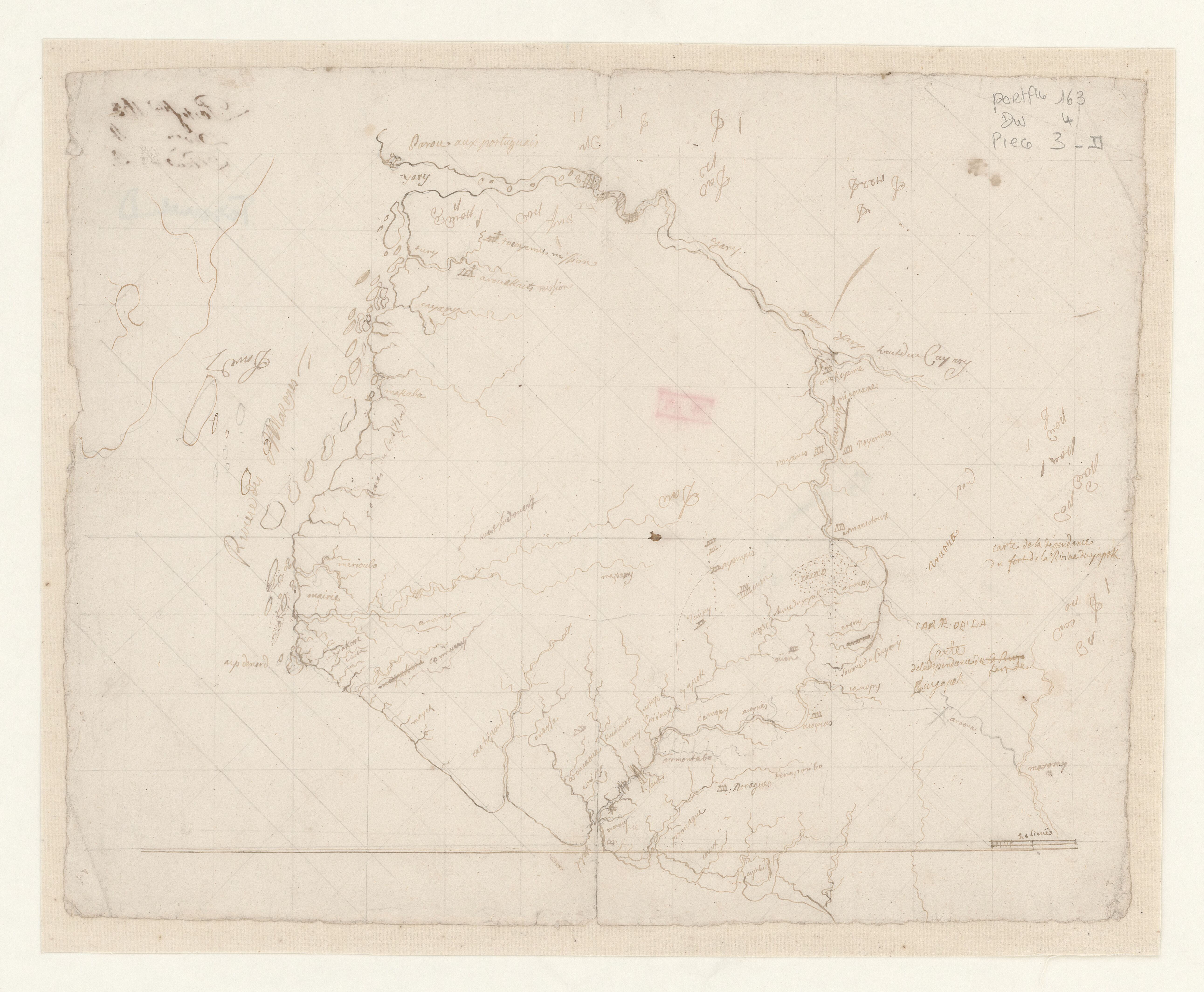
Dispossesions in the Americas

Dispossesions in the Americas

  • Home
  • Explore
  • About
  • Authors
  • Art
  • Bodies
  • Curricula
  • Cultural Heritage
  • Maps
  • Territories
Back to Explore
Map 1600 - 1799

Carte de la dépendance du fort de la rivière d'Oyapok

    Published: 1600-1799

    • Download Image

    Peoples

    • NORAGUES
    • AROQUAS
    • TARIPUY
    • OYAMPIS
    • ARMANTOTOUX
    • NOYENNES
    • COUYARY
    • AMICOUANES
    • OROKOYENNE
    • TOCOYENNE
    • AROUAKAITS
    • AROUCAOUE

    Citation

    "Carte de la dépendance du fort de la rivière d'Oyapok." Map. Accessed August 11, 2023. https://gallica.bnf.fr/ark:/12148/btv1b53103526x/f1.item.

    • Download Image

    Reading in Spanish

    Map 1600 - 1799

    Carte de la dépendance du fort de la rivière d'Oyapok

      Published: 1600-1799

      • Download Image
      • Download Image

      Reading in Portuguese

      Map 1600 - 1799

      Carte de la dépendance du fort de la rivière d'Oyapok

        Published: 1600-1799

        • Download Image

        Peoples

        • NORAGUES
        • AROQUAS
        • TARIPUY
        • OYAMPIS
        • ARMANTOTOUX
        • NOYENNES
        • COUYARY
        • AMICOUANES
        • OROKOYENNE
        • TOCOYENNE
        • AROUAKAITS
        • AROUCAOUE

        Citation

        "Carte de la dépendance du fort de la rivière d'Oyapok." Map. Accessed August 11, 2023. https://gallica.bnf.fr/ark:/12148/btv1b53103526x/f1.item.

        • Download Image

        Related Content

        Indigenous groups and Miskitu settlements in eastern Nicaragua.

        Indigenous groups and Miskitu settlements in eastern Nicaragua.

        Map 1990
        "Territorio Indígena Cabagra (Bribri)

        "Territorio Indígena Cabagra (Bribri)

        Map 2010
        THE KARANQAS AYMARA POLITY - Instant shot of trans-border connections around 1900 (Google Earth adaptation)

        THE KARANQAS AYMARA POLITY - Instant shot of trans-border connections around 1900 (Google Earth adaptation)

        Map 1860 - 1930
        CASIQUIARE;RIO ATABAPO;ET COURS INFERIEUR DE I’YNIRIDA

        CASIQUIARE;RIO ATABAPO;ET COURS INFERIEUR DE I’YNIRIDA

        Map 1872 - 1876
        Tribes of Chile and Northwest Argentina

        Tribes of Chile and Northwest Argentina

        Map
        Community Services

        Community Services

        Map 1997
        Mapa de Ubicacion de Grupos y Pueblos Indigenas en Aislamiento Voluntario

        Mapa de Ubicacion de Grupos y Pueblos Indigenas en Aislamiento Voluntario

        Map 2010
        Navegacion de Buques para el Darien. Mapa topográfico de una porción del Itsmo del Darién mostrando el sitio de la Navegación Pase Oceanico que se propone

        Navegacion de Buques para el Darien. Mapa topográfico de una porción del Itsmo del Darién mostrando el sitio de la Navegación Pase Oceanico que se propone

        Map 1852

        Dispossessions in the Americas

        A project by

        University of Pennsylvania

        Copyright 2024

        With support from

        Mellon Foundation

        Site design & development

        Element 84

        Art Credits

        “Carte de la dépendance du fort de la rivière d’Oyapok.” Map. Accessed August 11, 2023. https://gallica.bnf.fr/ark:/12148/btv1b53103526x/f1.item.

        Site Pages

        • Home
        • Explore
        • About
        • Authors
        • Art
        • Bodies
        • Curricula
        • Cultural Heritage
        • Maps
        • Territories