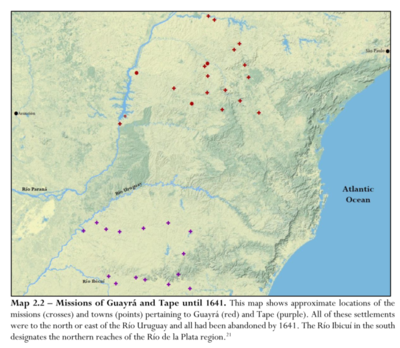
Dispossesions in the Americas

Dispossesions in the Americas

  • Home
  • Explore
  • About
  • Authors
  • Art
  • Bodies
  • Curricula
  • Cultural Heritage
  • Maps
  • Territories
Back to Explore
Map 1837

SOUTH AMERICA SHEET III. SOUTH BRAZIL WITH PARAGUAY AND URUGUAY

  • SOCIETY FOR THE DIFFUSION OF USEFUL KNOWLEDGE

Published: 1837

  • Download Image

Peoples

  • CHAVANTE
  • BOROROS
  • CAYAPOS
  • GUAYOAU
  • CAHAN

Citation

Society for the Diffusion of Useful Knowledge. South America sheet III. South Brazil with Paraguay and Uruguay. Map. London: Chapman and Hall, 1837. Accessed July 27, 2023. https://www.davidrumsey.com/luna/servlet/detail/RUMSEY~8~1~20988~530080.

  • Download Image

Reading in Spanish

Map 1837

SOUTH AMERICA SHEET III. SOUTH BRAZIL WITH PARAGUAY AND URUGUAY

  • SOCIETY FOR THE DIFFUSION OF USEFUL KNOWLEDGE

Published: 1837

  • Download Image
  • Download Image

Related Content

The Fort Yuma Reservation and Places Mentioned in the Text

The Fort Yuma Reservation and Places Mentioned in the Text

Map 2016
ARCHEOLOGICAL MAP OF MIDDLE AMERICA

ARCHEOLOGICAL MAP OF MIDDLE AMERICA

Map 1968
Ethnolinguistic territories of the Californias

Ethnolinguistic territories of the Californias

Map 2007
Copia del Plano Topográfico de la Ciudad de Lima, capital del Perú, y de su presidio y puerto del Callao, que como última observación de Latitud Austral, y demarcación geográfica de las costas de Chile y del Perú

Copia del Plano Topográfico de la Ciudad de Lima, capital del Perú, y de su presidio y puerto del Callao, que como última observación de Latitud Austral, y demarcación geográfica de las costas de Chile y del Perú

Map 1712
Sitios arqueológicos del Lago de Amatitlán, con lugares de ofrendas acuáticas.

Sitios arqueológicos del Lago de Amatitlán, con lugares de ofrendas acuáticas.

Map 2011
SKETCH MAP OF THE MISSIONS OF THE CATALONIAN CAPUCHINS IN THE SPANISH PROVINCE OF GUAYANA ABOUT 1771

SKETCH MAP OF THE MISSIONS OF THE CATALONIAN CAPUCHINS IN THE SPANISH PROVINCE OF GUAYANA ABOUT 1771

Map 1771
Pueblos indígenas en Argentina chaqueña

Pueblos indígenas en Argentina chaqueña

Map 2009
Demostración de las Provincias interiores del Perú, que componen parte del Virreynato de Buenos Ayres

Demostración de las Provincias interiores del Perú, que componen parte del Virreynato de Buenos Ayres

Map 1776

Dispossessions in the Americas

A project by

University of Pennsylvania

Copyright 2024

With support from

Mellon Foundation

Site design & development

Element 84

Art Credits

Society for the Diffusion of Useful Knowledge. South America sheet III. South Brazil with Paraguay and Uruguay. Map. London: Chapman and Hall, 1837. Accessed July 27, 2023. https://www.davidrumsey.com/luna/servlet/detail/RUMSEY~8~1~20988~530080.

Site Pages

  • Home
  • Explore
  • About
  • Authors
  • Art
  • Bodies
  • Curricula
  • Cultural Heritage
  • Maps
  • Territories