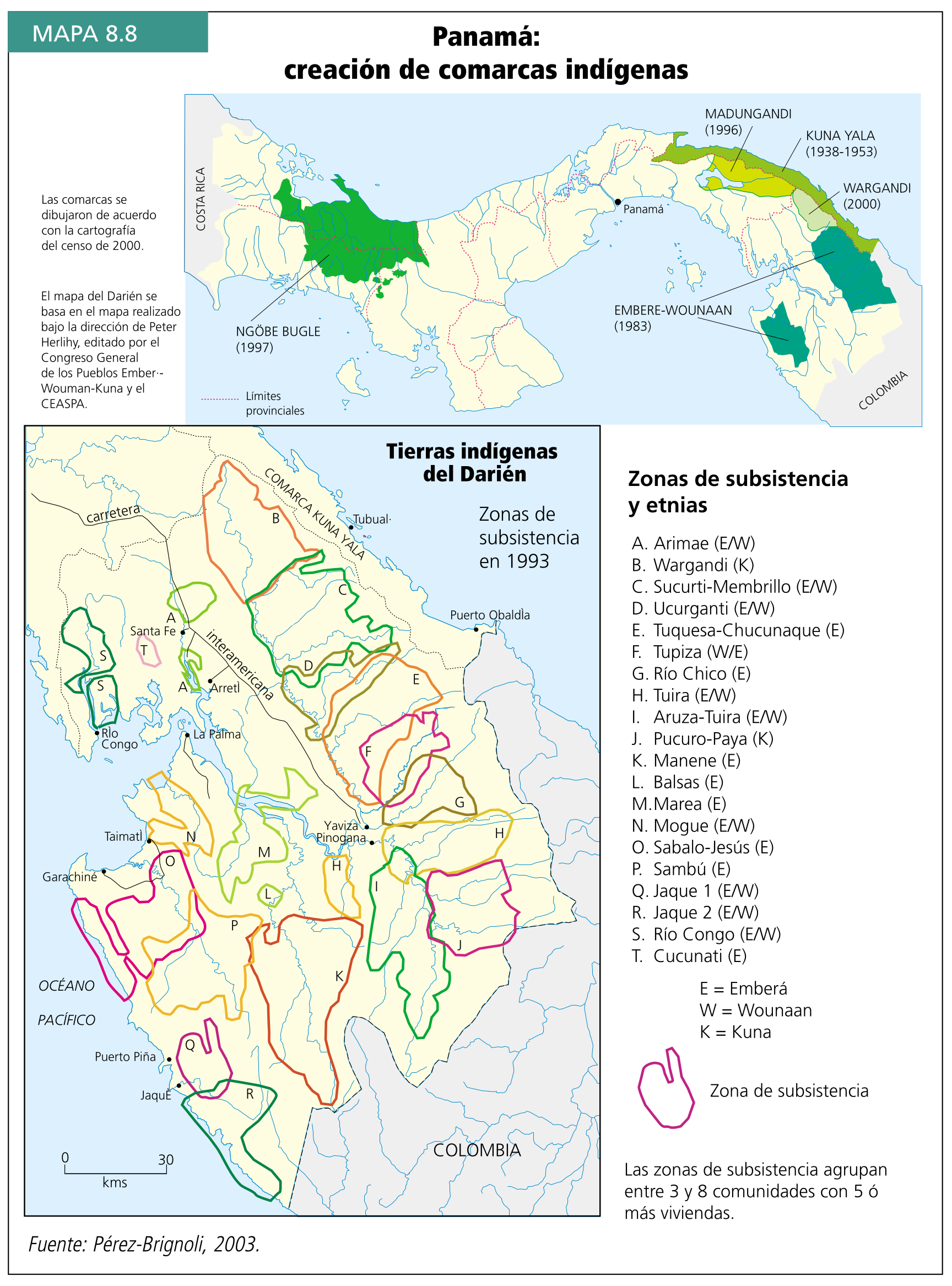
Dispossesions in the Americas

Dispossesions in the Americas

  • Home
  • Explore
  • About
  • Authors
  • Art
  • Bodies
  • Curricula
  • Cultural Heritage
  • Maps
  • Territories
Back to Explore
Map 1500 - 1599

PLATA AMERICAE PROVINCIA

  • WYTFLIET, CORNEILLE

Published: 1597

  • Download Image

Peoples

  • OUETACATES
  • TOUPINAMBAULTII
  • TOUPINIKINI
  • ACUTIA
  • MORPION
  • CARIOS

Citation

Wytfliet, Corneille, and Giovanni Antonio Magini. Plata Americae provincia. Map. Douai: Francois Fabri, 1597. https://www.davidrumsey.com/luna/servlet/detail/RUMSEY~8~1~296120~90067607.

  • Download Image

Reading in Spanish

Map 1500 - 1599

PLATA AMERICAE PROVINCIA

  • WYTFLIET, CORNEILLE

Published: 1597

  • Download Image
  • Download Image

Reading in Portuguese

Map 1500 - 1599

PLATA AMERICAE PROVINCIA

  • WYTFLIET, CORNEILLE

Published: 1597

  • Download Image

Peoples

  • OUETACATES
  • TOUPINAMBAULTII
  • TOUPINIKINI
  • ACUTIA
  • MORPION
  • CARIOS

Citation

Wytfliet, Corneille, and Giovanni Antonio Magini. Plata Americae provincia. Map. Douai: Francois Fabri, 1597. https://www.davidrumsey.com/luna/servlet/detail/RUMSEY~8~1~296120~90067607.

  • Download Image

Related Content

EMBOUCHURE DE LA RIVIERE DES AMAZONES

EMBOUCHURE DE LA RIVIERE DES AMAZONES

Map 1727
Panamá: creación de comarcas indígenas

Panamá: creación de comarcas indígenas

Map 2000
LOCALIZACIÓN DE LOS ASENTAMIENTOS GUAYABEROS SOBRE EL RIO GUAVIARE

LOCALIZACIÓN DE LOS ASENTAMIENTOS GUAYABEROS SOBRE EL RIO GUAVIARE

Map
REGIÓN PUREPECHA

REGIÓN PUREPECHA

Map 2000
CARTE de la Côte du Brésil DE RIO DE JANEIRO à l'Ihla Grande

CARTE de la Côte du Brésil DE RIO DE JANEIRO à l'Ihla Grande

Map 1700 - 1899
El manifiesto PrEP [The PrEP Manifesto]

El manifiesto PrEP [The PrEP Manifesto]

Artwork
Costa desde Cabo Falso;cerca del Cabo de Gracias a Dios;hasta Bluefields ("Campos Azules") (Nicaragua)

Costa desde Cabo Falso;cerca del Cabo de Gracias a Dios;hasta Bluefields ("Campos Azules") (Nicaragua)

Map 1784
THE CARACAS

THE CARACAS

Map 1810

Dispossessions in the Americas

A project by

University of Pennsylvania

Copyright 2024

With support from

Mellon Foundation

Site design & development

Element 84

Art Credits

Wytfliet, Corneille, and Giovanni Antonio Magini. Plata Americae provincia. Map. Douai: Francois Fabri, 1597. https://www.davidrumsey.com/luna/servlet/detail/RUMSEY~8~1~296120~90067607.

Site Pages

  • Home
  • Explore
  • About
  • Authors
  • Art
  • Bodies
  • Curricula
  • Cultural Heritage
  • Maps
  • Territories