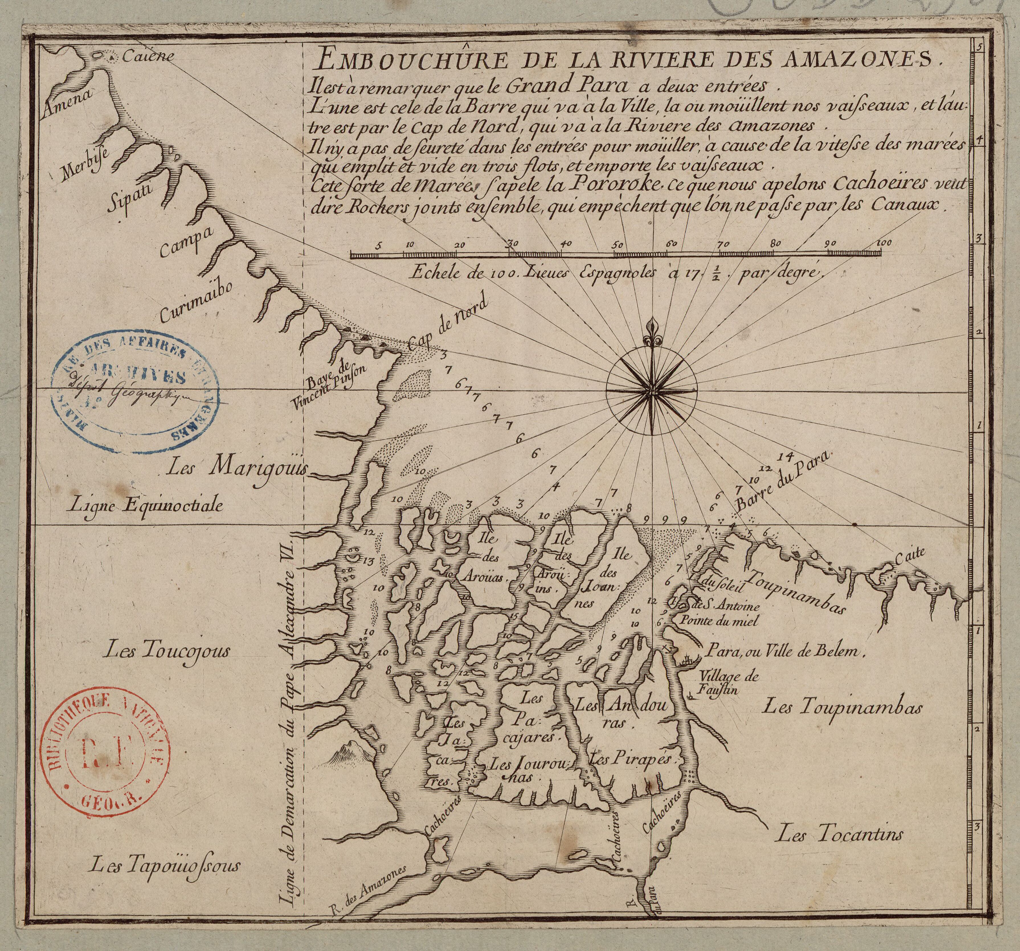
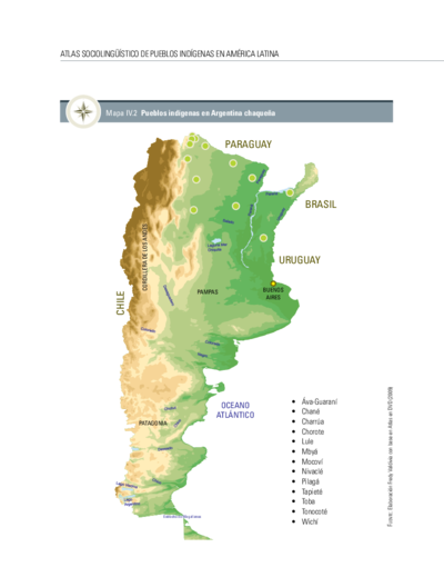
Dispossesions in the Americas

Dispossesions in the Americas

  • Home
  • Explore
  • About
  • Authors
  • Art
  • Bodies
  • Curricula
  • Cultural Heritage
  • Maps
  • Territories
Back to Explore
Map 1700 - 1799

EMBOUCHÛRE DE LA RIVIERE DES AMAZONES

    Published: 1700-1799

    • Download Image

    Peoples

    • MARIGOUIS
    • TOUCOJOUS
    • TAPOUIOSSOUS
    • TOCANTINS
    • TOUPINAMBAS
    • ANDOURAS
    • PIRAPES
    • JOUROUNAS
    • PACAJARES
    • JACARES
    • AROUAS

    Citation

    "Embouchure de la Rivière des Amazones." Map. Accessed July 28, 2023. https://gallica.bnf.fr/ark:/12148/btv1b85967588?rk=3004306;4.

    • Download Image

    Reading in Spanish

    Map 1700 - 1799

    EMBOUCHÛRE DE LA RIVIERE DES AMAZONES

      Published: 1700-1799

      • Download Image
      • Download Image

      Reading in Portuguese

      Map 1700 - 1799

      EMBOUCHÛRE DE LA RIVIERE DES AMAZONES

        Published: 1700-1799

        • Download Image

        Peoples

        • MARIGOUIS
        • TOUCOJOUS
        • TAPOUIOSSOUS
        • TOCANTINS
        • TOUPINAMBAS
        • ANDOURAS
        • PIRAPES
        • JOUROUNAS
        • PACAJARES
        • JACARES
        • AROUAS

        Citation

        "Embouchure de la Rivière des Amazones." Map. Accessed July 28, 2023. https://gallica.bnf.fr/ark:/12148/btv1b85967588?rk=3004306;4.

        • Download Image

        Related Content

        Orí Odé

        Orí Odé

        Artwork
        FAMILIAS LINGUÍSTICAS Y LENGUAS INDÍGENAS. OCTAVA REGION: PENINSULA DE LA GUAJIRA

        FAMILIAS LINGUÍSTICAS Y LENGUAS INDÍGENAS. OCTAVA REGION: PENINSULA DE LA GUAJIRA

        Map 1989
        Río del Orinoco nuevamente observado en bajante a fin de expresar sus Caudales;Yslas y bajos;Rios y Caños que tiene

        Río del Orinoco nuevamente observado en bajante a fin de expresar sus Caudales;Yslas y bajos;Rios y Caños que tiene

        Map 1732
        Paisaje [Landscape]

        Paisaje [Landscape]

        Artwork
        Distribution of Indian Languages in Central Mexico

        Distribution of Indian Languages in Central Mexico

        Map 1969
        Pueblos indígenas en Argentina chaqueña

        Pueblos indígenas en Argentina chaqueña

        Map 2009
        Cartografía social – confinamiento por la expansión minera en el sur de La Guajira

        Cartografía social – confinamiento por la expansión minera en el sur de La Guajira

        Map
        Bogando [Rowing]

        Bogando [Rowing]

        Artwork

        Dispossessions in the Americas

        A project by

        University of Pennsylvania

        Copyright 2024

        With support from

        Mellon Foundation

        Site design & development

        Element 84

        Art Credits

        “Embouchure de la Rivière des Amazones.” Map. Accessed July 28, 2023. https://gallica.bnf.fr/ark:/12148/btv1b85967588?rk=3004306;4.

        Site Pages

        • Home
        • Explore
        • About
        • Authors
        • Art
        • Bodies
        • Curricula
        • Cultural Heritage
        • Maps
        • Territories