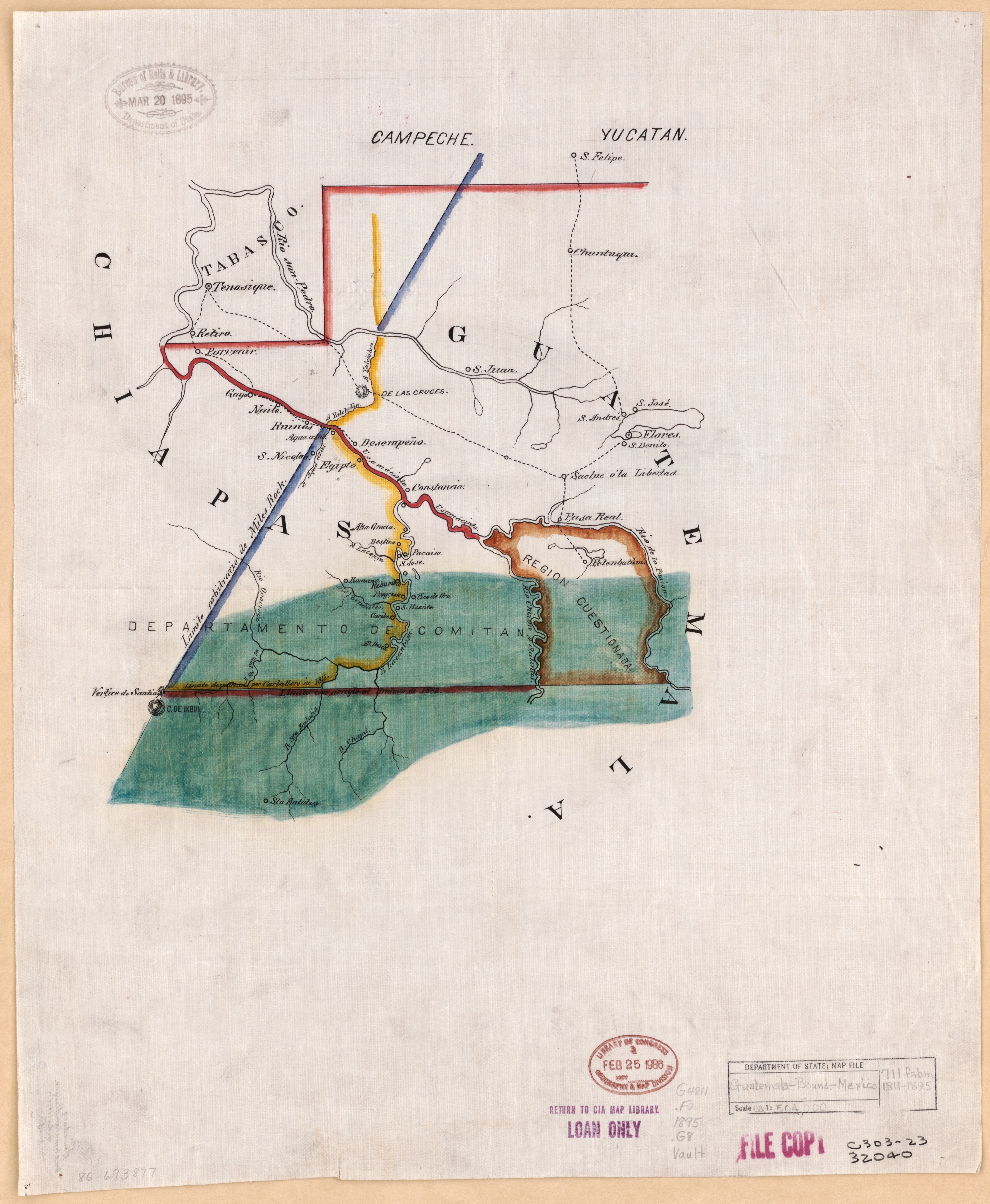
Dispossesions in the Americas

Dispossesions in the Americas

  • Home
  • Explore
  • About
  • Authors
  • Art
  • Bodies
  • Curricula
  • Cultural Heritage
  • Maps
  • Territories
Back to Explore
Map 1794

A New Chart of the Coast of Brazil from the Banks of St. Roque, to the Island of St. Sebastian;with the Islands and Soundings in the Offing

  • WHITTLE, JAMES, ET AL.

Published: 1794

  • Download Image

Peoples

  • INDIAN VILLAGE

Citation

Whittle, James, and Robert Laurie. A New Chart of the Coast of Brazil from the Banks of St. Roque, to the Island of St. Sebastian;with the Islands and Soundings in the Offing. Map. London: Laurie & Whittle, 1794. Accessed July 26, 2023. https://gallica.bnf.fr/ark:/12148/btv1b53123069n/f1.item.

  • Download Image

Reading in Spanish

Map 1794

A New Chart of the Coast of Brazil from the Banks of St. Roque, to the Island of St. Sebastian;with the Islands and Soundings in the Offing

  • WHITTLE, JAMES, ET AL.

Published: 1794

  • Download Image
  • Download Image

Reading in Portuguese

Map 1794

A New Chart of the Coast of Brazil from the Banks of St. Roque, to the Island of St. Sebastian;with the Islands and Soundings in the Offing

  • WHITTLE, JAMES, ET AL.

Published: 1794

  • Download Image

Peoples

  • INDIAN VILLAGE

Citation

Whittle, James, and Robert Laurie. A New Chart of the Coast of Brazil from the Banks of St. Roque, to the Island of St. Sebastian;with the Islands and Soundings in the Offing. Map. London: Laurie & Whittle, 1794. Accessed July 26, 2023. https://gallica.bnf.fr/ark:/12148/btv1b53123069n/f1.item.

  • Download Image

Related Content

[Plano de la Isla de Cuba con los derroteros de las naves que vienen de Nueva España al Reino que llaman de Bahama el Nuevo y de las que van a Nueva España y Veracruz]

[Plano de la Isla de Cuba con los derroteros de las naves que vienen de Nueva España al Reino que llaman de Bahama el Nuevo y de las que van a Nueva España y Veracruz]

Map 1500 - 1599
Guatemala-boundary- Mexico

Guatemala-boundary- Mexico

Map 1895
MAPA 2. ZITT Y ZONA DE AMORTIGUAMIENTO.

MAPA 2. ZITT Y ZONA DE AMORTIGUAMIENTO.

Map 2015
Carta de la Costa de Mosquitos;con sus islas;cayos;bancos y bajos adyacentes entre dicha y la Isla de Jamayca

Carta de la Costa de Mosquitos;con sus islas;cayos;bancos y bajos adyacentes entre dicha y la Isla de Jamayca

Map 1767 - 1781
AM, Brazil - Pot

AM, Brazil - Pot

Artwork
Mapa de Ubicacion de Grupos y Pueblos Indigenas en Aislamiento Voluntario

Mapa de Ubicacion de Grupos y Pueblos Indigenas en Aislamiento Voluntario

Map 2010
Mapa de la Peninsula Goagira

Mapa de la Peninsula Goagira

Map 1762
MAPA DE TEPEJÍ DEL RÍO

MAPA DE TEPEJÍ DEL RÍO

Map 1500 - 1599

Dispossessions in the Americas

A project by

University of Pennsylvania

Copyright 2024

With support from

Mellon Foundation

Site design & development

Element 84

Art Credits

Whittle, James, and Robert Laurie. A New Chart of the Coast of Brazil from the Banks of St. Roque, to the Island of St. Sebastian;with the Islands and Soundings in the Offing. Map. London: Laurie & Whittle, 1794. Accessed July 26, 2023. https://gallica.bnf.fr/ark:/12148/btv1b53123069n/f1.item.

Site Pages

  • Home
  • Explore
  • About
  • Authors
  • Art
  • Bodies
  • Curricula
  • Cultural Heritage
  • Maps
  • Territories