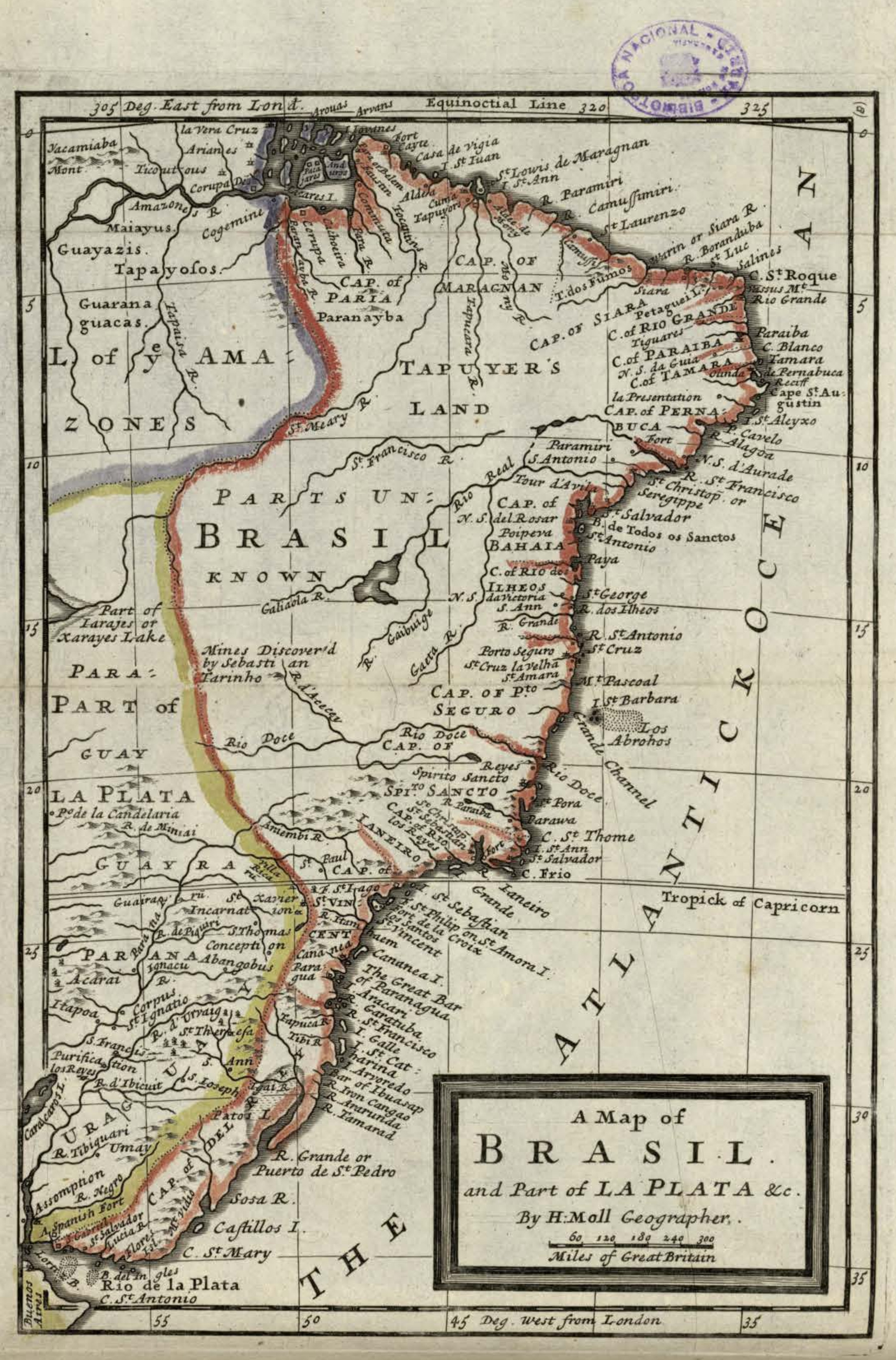
Dispossesions in the Americas

Dispossesions in the Americas

  • Home
  • Explore
  • About
  • Authors
  • Art
  • Bodies
  • Curricula
  • Cultural Heritage
  • Maps
  • Territories
Back to Explore
Map 1717

A Map of BRASIL and Part of LA PLATA

  • MOLL, HERMAN

Published: 1717

  • Download Image

Peoples

  • MAIAYUS
  • GUAYAZIS
  • TAPAYOSOS
  • GUARANAGUACAS
  • TAPUYER

Citation

Moll, Herman. "A Map of Brasil and Part of La Plata." Map. In America, 254. Vol. 5 of Atlas Geographus or, a compleat System of Geography, ancient and modern. London: John Nutt, 1717. Accessed July 14, 2023. http://bdh.bne.es/bnesearch/detalle/bdh0000163462.

  • Download Image

Reading in Spanish

Map 1717

A Map of BRASIL and Part of LA PLATA

  • MOLL, HERMAN

Published: 1717

  • Download Image
  • Download Image

Reading in Portuguese

Map 1717

A Map of BRASIL and Part of LA PLATA

  • MOLL, HERMAN

Published: 1717

  • Download Image

Peoples

  • MAIAYUS
  • GUAYAZIS
  • TAPAYOSOS
  • GUARANAGUACAS
  • TAPUYER

Citation

Moll, Herman. "A Map of Brasil and Part of La Plata." Map. In America, 254. Vol. 5 of Atlas Geographus or, a compleat System of Geography, ancient and modern. London: John Nutt, 1717. Accessed July 14, 2023. http://bdh.bne.es/bnesearch/detalle/bdh0000163462.

  • Download Image

Related Content

La selva está caliente [The Jungle is Hot]

La selva está caliente [The Jungle is Hot]

Artwork
Mami y Yo y Mi Gallito [Mommy, Me, and My Little Rooster]

Mami y Yo y Mi Gallito [Mommy, Me, and My Little Rooster]

Artwork
Cover-up of the Ponce de Leon statue at the Antorcha de la Amistad in Miami, Florida

Cover-up of the Ponce de Leon statue at the Antorcha de la Amistad in Miami, Florida

Artwork
Matrimonios Sogamoso

Matrimonios Sogamoso

Map 1500 - 1600
Fig. 1. Les Indiens de la Guyane Française en 1958

Fig. 1. Les Indiens de la Guyane Française en 1958

Map 1958
INTENDENCIA DE SONORA-SINOLOA

INTENDENCIA DE SONORA-SINOLOA

Map 1800
Map of the Inca Empire in western South America

Map of the Inca Empire in western South America

Map 1310 - 1525
Territorio ancestral y territorio agrario 2015

Territorio ancestral y territorio agrario 2015

Map 2015

Dispossessions in the Americas

A project by

University of Pennsylvania

Copyright 2024

With support from

Mellon Foundation

Site design & development

Element 84

Art Credits

Moll, Herman. “A Map of Brasil and Part of La Plata.” Map. In America, 254. Vol. 5 of Atlas Geographus or, a compleat System of Geography, ancient and modern. London: John Nutt, 1717. Accessed July 14, 2023. http://bdh.bne.es/bnesearch/detalle/bdh0000163462.

Site Pages

  • Home
  • Explore
  • About
  • Authors
  • Art
  • Bodies
  • Curricula
  • Cultural Heritage
  • Maps
  • Territories