Dispossesions in the Americas

Dispossesions in the Americas

  • Home
  • Explore
  • About
  • Authors
  • Art
  • Bodies
  • Curricula
  • Cultural Heritage
  • Maps
  • Territories
Back to Explore
Map 1800 - 1899

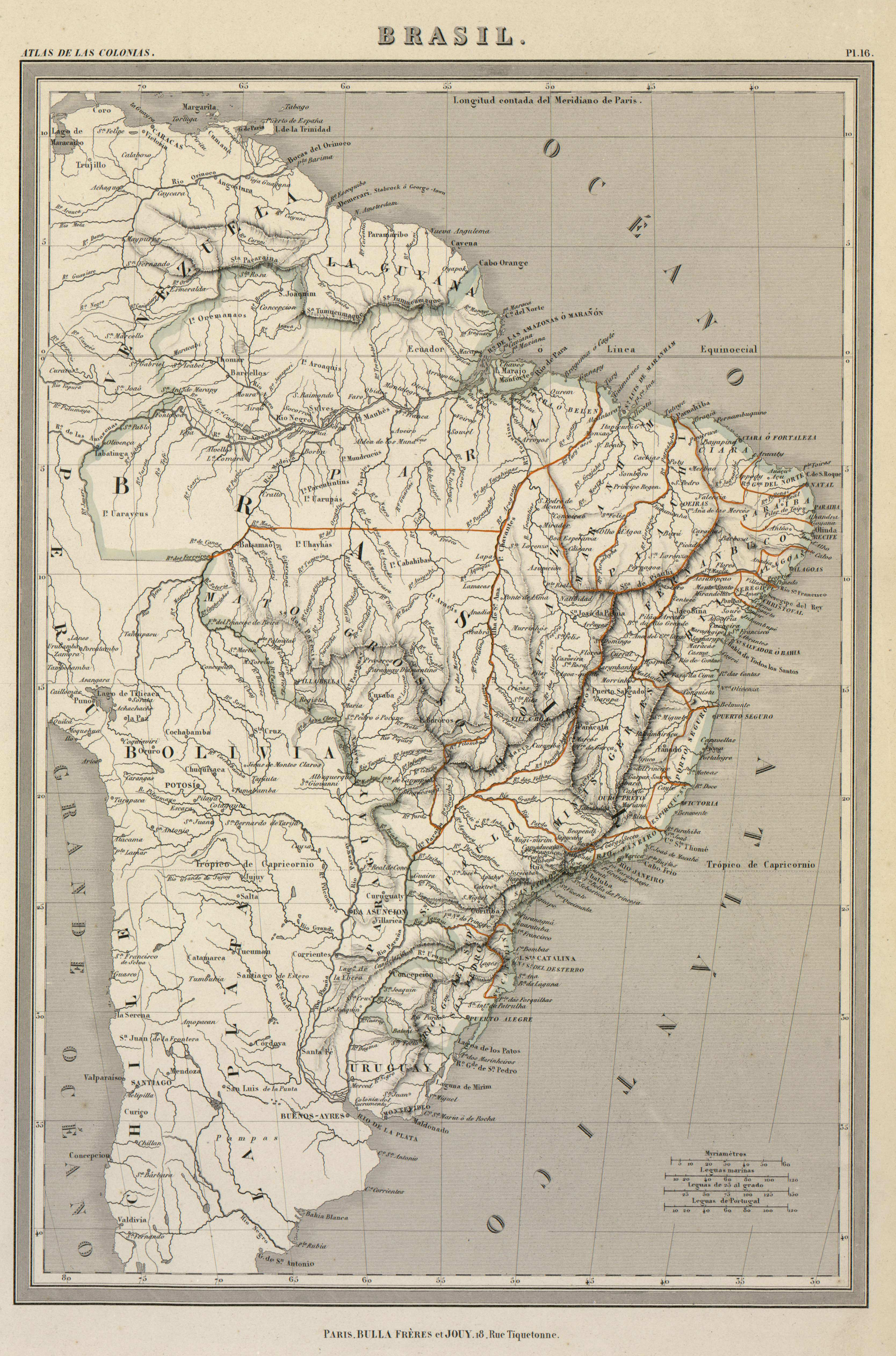
BRASIL

  • DUFOUR, AUGUSTE-HENRI

Published: 1800-1899

  • Download Image

Peoples

  • OREMANAOS
  • MAUHES
  • MUNDURUCUS
  • AROAQUIS
  • UARAYEUS
  • UARUPAS
  • PARENTINTINS
  • UHAYHAS
  • CABAHIBAS
  • CHAVANTES
  • ARACIS
  • BOROROS

Citation

DUFOUR, AUGUSTE-HENRI. "Brasil." Map. In Atlas de Géographie élémentaire, by Auguste-Henri Dufour, 16. Paris: Bulla Frères et Jouy, n.d. Accessed July 11, 2023. http://bdh.bne.es/bnesearch/detalle/bdh0000001461.
  • Download Image

Reading in Spanish

Map 1800 - 1899

BRASIL

  • DUFOUR, AUGUSTE-HENRI

Published: 1800-1899

  • Download Image
  • Download Image

Related Content

"Territorio Indígena Kekoldi (Bribri)"

"Territorio Indígena Kekoldi (Bribri)"

Map 2010
The Geography of Peninsular Languages

The Geography of Peninsular Languages

Map 1994
THE CARIBBEE ISLANDS AND GUAYANA DRAWN BY L. DELAROCHETTE

THE CARIBBEE ISLANDS AND GUAYANA DRAWN BY L. DELAROCHETTE

Map 1776
"Transversalidad Histórica entre las Tierras Indidas de 1940 y los Pueblos Indígenas de Costa Rica en la actualidad"

"Transversalidad Histórica entre las Tierras Indidas de 1940 y los Pueblos Indígenas de Costa Rica en la actualidad"

Map 1940 - 2014
Detail from the 1770 copy of Francisco Álvarez Barreiro’s 1728 map of northern New Spain illustrating Spanish mapping of Indian domains in southern Texas and along the Gulf Coast, especially through the repetition of labels: “tierra de los Pampopas,” “tierra de los Carrizos,” “tierra de los Cujanes,” etc.

Detail from the 1770 copy of Francisco Álvarez Barreiro’s 1728 map of northern New Spain illustrating Spanish mapping of Indian domains in southern Texas and along the Gulf Coast, especially through the repetition of labels: “tierra de los Pampopas,” “tierra de los Carrizos,” “tierra de los Cujanes,” etc.

Map 1728
Carta plana de la provincia de La Hacha situada entre las de Santa Marta y Maracaybo

Carta plana de la provincia de La Hacha situada entre las de Santa Marta y Maracaybo

Map 1786
Territorio ancestral y territorio agrario 2015

Territorio ancestral y territorio agrario 2015

Map 2015
Comunidad Indígena Tonokoté Breáyoj - Pueblo Tonokoté

Comunidad Indígena Tonokoté Breáyoj - Pueblo Tonokoté

Map 2020

Dispossessions in the Americas

A project by

University of Pennsylvania

Copyright 2024

With support from

Mellon Foundation

Site design & development

Element 84

Art Credits

DUFOUR, AUGUSTE-HENRI. “Brasil.” Map. In Atlas de Géographie élémentaire, by Auguste-Henri Dufour, 16. Paris: Bulla Frères et Jouy, n.d. Accessed July 11, 2023. http://bdh.bne.es/bnesearch/detalle/bdh0000001461.
Site Pages

  • Home
  • Explore
  • About
  • Authors
  • Art
  • Bodies
  • Curricula
  • Cultural Heritage
  • Maps
  • Territories