Dispossesions in the Americas

Dispossesions in the Americas

  • Home
  • Explore
  • About
  • Authors
  • Art
  • Bodies
  • Curricula
  • Cultural Heritage
  • Maps
  • Territories
Back to Explore
Map 2011

Terra Indígena Bananal (Peruíbe)

  • COMISSAO PRO-INDIO DE SAO PAULO

Published: 2016

  • Download Image

Peoples

  • GUARANI NANDEVA

Citation

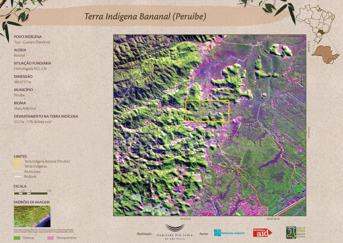
Comissão Pró-Índio de São Paulo. "Terra Indígena Bananal (Peruíbe)." Map. Comissão Pró-Índio de São Paulo. December 2016. Accessed July 3, 2023. https://cpisp.org.br/wp-content/uploads/2016/12/TI_Bananal.jpg.

  • Download Image

Reading in Spanish

Map 2011

Terra Indígena Bananal (Peruíbe)

  • COMISSAO PRO-INDIO DE SAO PAULO

Published: 2016

  • Download Image
  • Download Image

Related Content

Rio Para

Rio Para

Map 1700 - 1750
PUEBLOS DE INDIOS DE LAS INTENDENCIAS Y GOBIERNOS MILITARES DE LA NUEVA ESPAÑA EN 1800 (4,468 PUEBLOS DE INDIOS)

PUEBLOS DE INDIOS DE LAS INTENDENCIAS Y GOBIERNOS MILITARES DE LA NUEVA ESPAÑA EN 1800 (4,468 PUEBLOS DE INDIOS)

Map 1800
Carte de la dépendance du Yapok jusqu'à la Rivière des Amazones;par François Duvillard garde magazin du Roy au Yapok

Carte de la dépendance du Yapok jusqu'à la Rivière des Amazones;par François Duvillard garde magazin du Roy au Yapok

Map 1700 - 1799
Lenguas indígenas de la Amazonia venezolana
(y otras regiones del país)

Lenguas indígenas de la Amazonia venezolana (y otras regiones del país)

Map 1998
Fig. 1 Map of the Guianas with schematic locations of the
indigenous groups relevant to our study, based on the linguistic
map of South America (http://www.muturzikin.com/cartesamerique/
7.htm). Carib-speaking groups are indicated in yellow, Arawak-speaking
groups in blue, Tupi-speaking Wayãpi in pink and the Warao-speaking
group in green

Fig. 1 Map of the Guianas with schematic locations of the indigenous groups relevant to our study, based on the linguistic map of South America (http://www.muturzikin.com/cartesamerique/ 7.htm). Carib-speaking groups are indicated in yellow, Arawak-speaking groups in blue, Tupi-speaking Wayãpi in pink and the Warao-speaking group in green

Map 2000 - 2024
PLATA AMERICAE PROVINCIA

PLATA AMERICAE PROVINCIA

Map 1500 - 1599
PROVINCIAS DEL QULLASUYU BAJO DOMINIO INCA PRINCIPIOS DEL SIGLO XVI

PROVINCIAS DEL QULLASUYU BAJO DOMINIO INCA PRINCIPIOS DEL SIGLO XVI

Map 1530 - 1540
"Territorio Indígena Coto Brus (Ngöbes)"

"Territorio Indígena Coto Brus (Ngöbes)"

Map 2010

Dispossessions in the Americas

A project by

University of Pennsylvania

Copyright 2024

With support from

Mellon Foundation

Site design & development

Element 84

Art Credits

Comissão Pró-Índio de São Paulo. “Terra Indígena Bananal (Peruíbe).” Map. Comissão Pró-Índio de São Paulo. December 2016. Accessed July 3, 2023. https://cpisp.org.br/wp-content/uploads/2016/12/TI_Bananal.jpg.

Site Pages

  • Home
  • Explore
  • About
  • Authors
  • Art
  • Bodies
  • Curricula
  • Cultural Heritage
  • Maps
  • Territories