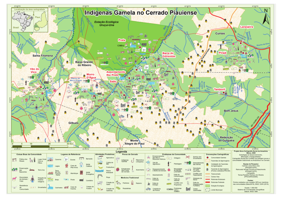
Dispossesions in the Americas

Dispossesions in the Americas

  • Home
  • Explore
  • About
  • Authors
  • Art
  • Bodies
  • Curricula
  • Cultural Heritage
  • Maps
  • Territories
Back to Explore
Map 2000 - 2099

Indígenas Gamela no Cerrado Piauiense

  • PAOLIELLO PACHECHO DE OLIVEIRA, TOMAS

Published: 2020

  • Download Image

Peoples

  • GAMELA

Citation

Paoliello Pachecho de Oliveira, Tomas. "Indígenas Gamela no Cerrado Piauiense."Map. Nova Cartografia Social Da Amazônia. 2020. Accessed July 1, 2023. http://novacartografiasocial.com.br/download/01-indigenas-gamela-no-cerrado-piauiense/.

  • Download Image

Reading in Spanish

Map 2000 - 2099

Indígenas Gamela no Cerrado Piauiense

  • PAOLIELLO PACHECHO DE OLIVEIRA, TOMAS

Published: 2020

  • Download Image
  • Download Image

Reading in Portuguese

Map 2000 - 2099

Indígenas Gamela no Cerrado Piauiense

  • PAOLIELLO PACHECHO DE OLIVEIRA, TOMAS

Published: 2020

  • Download Image

Peoples

  • GAMELA

Citation

Paoliello Pachecho de Oliveira, Tomas. "Indígenas Gamela no Cerrado Piauiense."Map. Nova Cartografia Social Da Amazônia. 2020. Accessed July 1, 2023. http://novacartografiasocial.com.br/download/01-indigenas-gamela-no-cerrado-piauiense/.

  • Download Image

Related Content

PUEBLO AWAKATECO

PUEBLO AWAKATECO

Map 2020
PAA. Pan American Flight Map. New York and Caribbean.

PAA. Pan American Flight Map. New York and Caribbean.

Map 1508 - 1783
REPRESENTACIÓN EN FORMA DE TRÍPTICO DE LAS TIERRAS DE TEPAL;CUENCA;CORRESPONDE AL EXPEDIENTE PROMOVIDO POR POSESIÓN DE TIERRAS ENTRE LOS INDÍGENAS DE SANTA ANA DE PICHACAY CONTRA MARÍA Y FRANCISCA CAZAR

REPRESENTACIÓN EN FORMA DE TRÍPTICO DE LAS TIERRAS DE TEPAL;CUENCA;CORRESPONDE AL EXPEDIENTE PROMOVIDO POR POSESIÓN DE TIERRAS ENTRE LOS INDÍGENAS DE SANTA ANA DE PICHACAY CONTRA MARÍA Y FRANCISCA CAZAR

Map 1828
Serie Fatherland / Padre Patria

Serie Fatherland / Padre Patria

Artwork
Geographic Distribution of the Amuzgo

Geographic Distribution of the Amuzgo

Map 1969
INTENDENCIA DE MÉXICO

INTENDENCIA DE MÉXICO

Map 1800
Carte Du Bresil. Prem. Partie ;Depuis la Riviere des Amazones jusquà la Baye de Tous les Sants;Pour servir à l'Histoire Générale des Voyages

Carte Du Bresil. Prem. Partie ;Depuis la Riviere des Amazones jusquà la Baye de Tous les Sants;Pour servir à l'Histoire Générale des Voyages

Map 1700 - 1750
La Guyane française et le territoire de l'Inini.

La Guyane française et le territoire de l'Inini.

Map 1933

Dispossessions in the Americas

A project by

University of Pennsylvania

Copyright 2024

With support from

Mellon Foundation

Site design & development

Element 84

Art Credits

Paoliello Pachecho de Oliveira, Tomas. “Indígenas Gamela no Cerrado Piauiense.“Map. Nova Cartografia Social Da Amazônia. 2020. Accessed July 1, 2023. http://novacartografiasocial.com.br/download/01-indigenas-gamela-no-cerrado-piauiense/.

Site Pages

  • Home
  • Explore
  • About
  • Authors
  • Art
  • Bodies
  • Curricula
  • Cultural Heritage
  • Maps
  • Territories