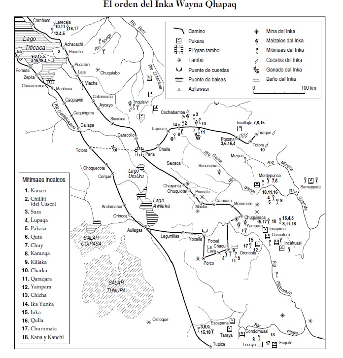
Dispossesions in the Americas

Dispossesions in the Americas

  • Home
  • Explore
  • About
  • Authors
  • Art
  • Bodies
  • Curricula
  • Cultural Heritage
  • Maps
  • Territories
Back to Explore
Map 1500 - 1530

SPATIAL ORGANIZATION OF THE QULLASUYU UNDER INCA RULE

  • Platt, T., Bouysse-Cassagne, T., & Harris, O.

Published: 2006

  • Download Image

Peoples

  • KANARI
  • CHILLKI
  • SURA
  • LUPAQA
  • PAKASA (PACAJE)
  • QUTA
  • KARANQA
  • KILLAKA
  • CHARKA
  • QARAQARA
  • YAMPARA
  • CHICHA
  • IKA YUNKA
  • INKA
  • QULLA
  • QULLA
  • CHURUMATA
  • KANA
  • KANCHI

Citation

Platt, T., Bouysse-Cassagne, T., & Harris, O. (2006). Qaraqara-Charka: Mallku, Inka y rey en la Provincia de Charcas (siglos XV – XVII): Historia antropológica de una confederación aymara. Edicion documental y ensayos interpretativos. Con el aliento de Thierry Saignes. Instituto Frances de Estudios Andinos, Plural Editores, Fundacion Cultural del Banco Central de Bolivia, University of St. Andrews.

  • Download Image

Reading in Spanish

Map 1500 - 1530

SPATIAL ORGANIZATION OF THE QULLASUYU UNDER INCA RULE

  • Platt, T., Bouysse-Cassagne, T., & Harris, O.

Published: 2006

  • Download Image
  • Download Image

Related Content

Ethnolinguistic territories of the Californias

Ethnolinguistic territories of the Californias

Map 2007
RELACIÓN GEOGRÁFICA DE SANTIAGO TEJUPAN

RELACIÓN GEOGRÁFICA DE SANTIAGO TEJUPAN

Map 1500 - 1599
MAPAS DAS PROVINCIAS ETNOGRÁFICAS NO TERRITÓRIO DO RIO GRANDE DO SUL

MAPAS DAS PROVINCIAS ETNOGRÁFICAS NO TERRITÓRIO DO RIO GRANDE DO SUL

Map 1500 - 1600
Croquis III. (b) La región andina septentrional ecuatoriana (Moreno Yanez;1989;2)

Croquis III. (b) La región andina septentrional ecuatoriana (Moreno Yanez;1989;2)

Map -500 - 1530
Carte d'une partie de la Guyanne extraite des observations faites en 1762, 1763 et 1764.

Carte d'une partie de la Guyanne extraite des observations faites en 1762, 1763 et 1764.

Map 1762 - 1764
Paraguay Tribal Map

Paraguay Tribal Map

Map
CÓDICE XOLOTL

CÓDICE XOLOTL

Map 1100 - 1499
Carte du Pérou, ou se trouvent les Audiences de Quito, Lima et la Plata projettée et assujettie aux observations astronomiques

Carte du Pérou, ou se trouvent les Audiences de Quito, Lima et la Plata projettée et assujettie aux observations astronomiques

Map 1771

Dispossessions in the Americas

A project by

University of Pennsylvania

Copyright 2024

With support from

Mellon Foundation

Site design & development

Element 84

Art Credits

Platt, T., Bouysse-Cassagne, T., & Harris, O. (2006). Qaraqara-Charka: Mallku, Inka y rey en la Provincia de Charcas (siglos XV – XVII): Historia antropológica de una confederación aymara. Edicion documental y ensayos interpretativos. Con el aliento de Thierry Saignes. Instituto Frances de Estudios Andinos, Plural Editores, Fundacion Cultural del Banco Central de Bolivia, University of St. Andrews.

Site Pages

  • Home
  • Explore
  • About
  • Authors
  • Art
  • Bodies
  • Curricula
  • Cultural Heritage
  • Maps
  • Territories