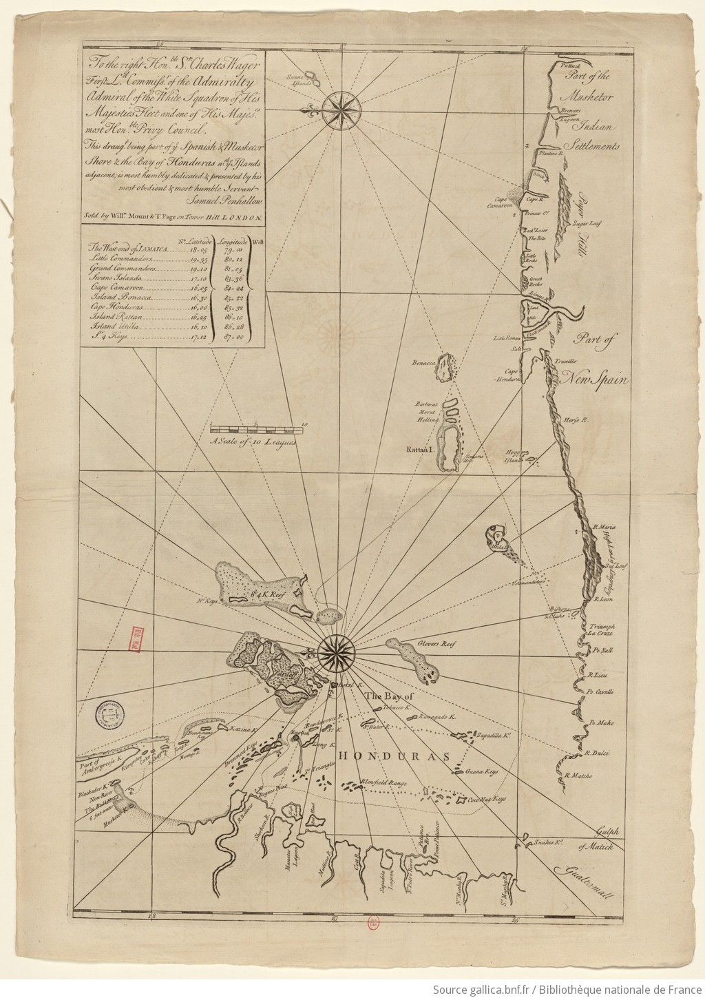
Dispossesions in the Americas

Dispossesions in the Americas

  • Home
  • Explore
  • About
  • Authors
  • Art
  • Bodies
  • Curricula
  • Cultural Heritage
  • Maps
  • Territories
Back to Explore
Map 1735

The Spanish and Musketor shore and the bay of Honduras and the islands adjacent

  • Samuel Penhallon

Published: 1735

  • Download Image

Peoples

  • INDIAN

Citation

Samuel Penhallon. 1735. "The Spanish and Musketor shore and the bay of Honduras and the islands adjacent." Bibliothèque nationale de France, département Cartes et plans, GE SH 18 PF 143 DIV 2 P 1. Accessed April 26, 2024. https://gallica.bnf.fr/ark:/12148/btv1b5970790d/f1.item.zoom.

  • Download Image

Reading in Spanish

Map 1735

The Spanish and Musketor shore and the bay of Honduras and the islands adjacent

  • Samuel Penhallon

Published: 1735

  • Download Image
  • Download Image

Related Content

Carte 23: Guyane

Carte 23: Guyane

Map 1900 - 1999
Parte de la América Meridional

Parte de la América Meridional

Map 1764 - 1767
Sketch map of part of RÍO ORINOCO and RIO CUCHIVERO from a survey by MAJOR STANLEY PATERSON

Sketch map of part of RÍO ORINOCO and RIO CUCHIVERO from a survey by MAJOR STANLEY PATERSON

Map 1896
Áreas con presencia de grupos ayoreo aislados dentro y fuera de su territorio traditional, en Paraguay y Bolivia, registrados hasta 2017

Áreas con presencia de grupos ayoreo aislados dentro y fuera de su territorio traditional, en Paraguay y Bolivia, registrados hasta 2017

Map 2017
Chinantla Subregions

Chinantla Subregions

Map 1969
Tenencia de Tierra en Isla de Pascua hacia 2003

Tenencia de Tierra en Isla de Pascua hacia 2003

Map 2003
THE ARGENTINE REPUBLIC;CHILE;PARAGUAY AND URUGUAY

THE ARGENTINE REPUBLIC;CHILE;PARAGUAY AND URUGUAY

Map 1887
Transversiva Post Andina Revolucionaria: El Regreso [Revolutionary Post-Andean Transversiva: The Return]

Transversiva Post Andina Revolucionaria: El Regreso [Revolutionary Post-Andean Transversiva: The Return]

Artwork

Dispossessions in the Americas

A project by

University of Pennsylvania

Copyright 2024

With support from

Mellon Foundation

Site design & development

Element 84

Art Credits

Samuel Penhallon. 1735. “The Spanish and Musketor shore and the bay of Honduras and the islands adjacent.” Bibliothèque nationale de France, département Cartes et plans, GE SH 18 PF 143 DIV 2 P 1. Accessed April 26, 2024. https://gallica.bnf.fr/ark:/12148/btv1b5970790d/f1.item.zoom.

Site Pages

  • Home
  • Explore
  • About
  • Authors
  • Art
  • Bodies
  • Curricula
  • Cultural Heritage
  • Maps
  • Territories