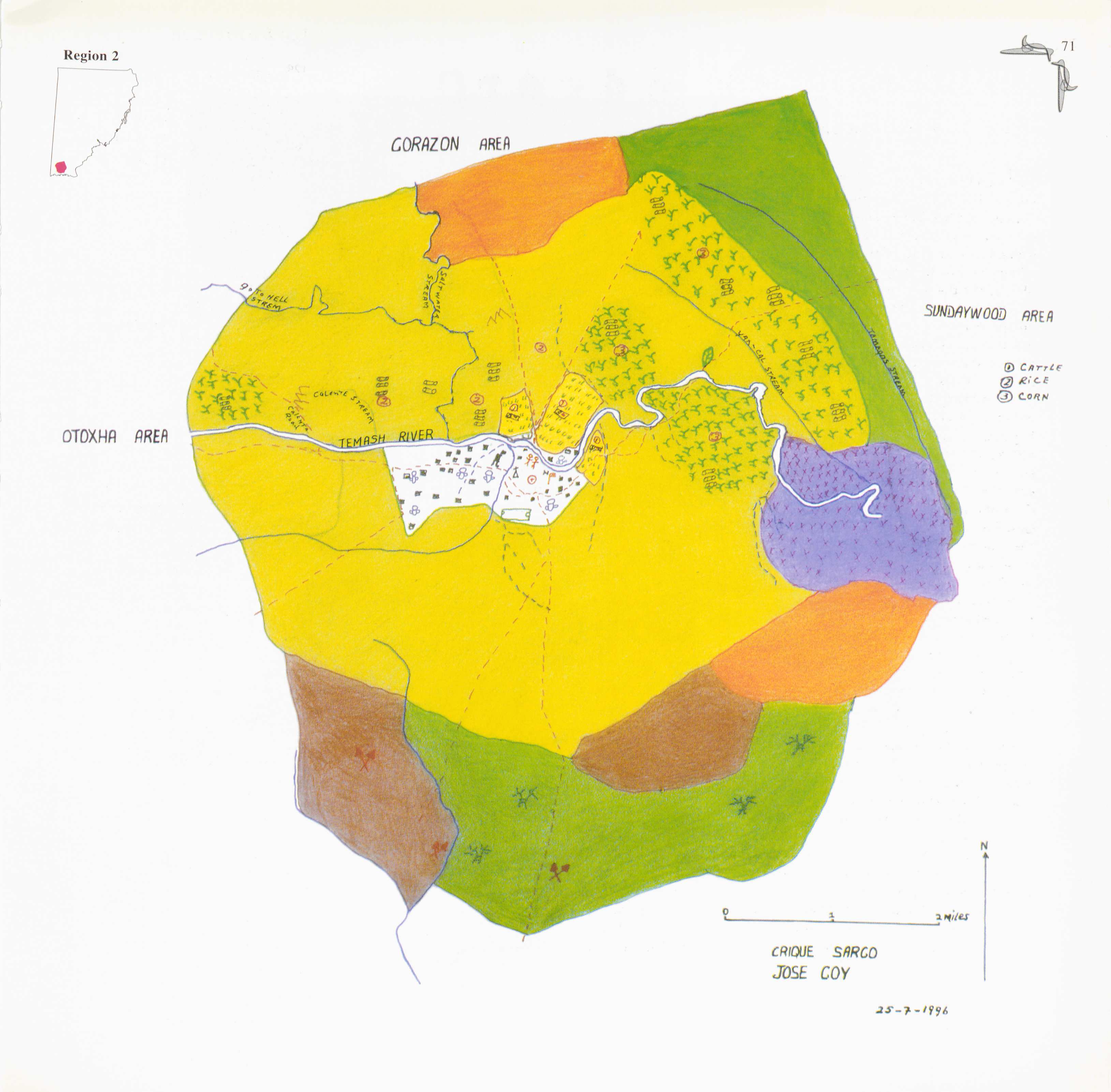
Dispossesions in the Americas

Dispossesions in the Americas

  • Home
  • Explore
  • About
  • Authors
  • Art
  • Bodies
  • Curricula
  • Cultural Heritage
  • Maps
  • Territories
Back to Explore
Map 1997

Crique Sarco

  • Jose Coy

Published: 1997

  • Download Image

Peoples

  • KE'KCHI

Citation

Jose Coy. 1997. "Crique Sarco." In Maya Atlas: The Struggle to Preserve Maya Land in Southern Belize, 70. Berkeley, CA: North Atlantic Books. BOOK

  • Download Image

Reading in Spanish

Map 1997

Crique Sarco

  • Jose Coy

Published: 1997

  • Download Image
  • Download Image

Related Content

ANAHUAC Comprenant les Royaumes de Mexico, d'Acolhuacan, de Mechoacan, et les Republiques de Tlascala, de Cholula, de Huexotxinco & Tels qu 'ils etaient das l'annee 1521

ANAHUAC Comprenant les Royaumes de Mexico, d'Acolhuacan, de Mechoacan, et les Republiques de Tlascala, de Cholula, de Huexotxinco & Tels qu 'ils etaient das l'annee 1521

Map 1843
Nieuwe Caerte van het wonderbaer ende goudrijcke landt Guiana, gelegen onder de Linie Aequinoctiael tusschen Brasilien ende Péru.

Nieuwe Caerte van het wonderbaer ende goudrijcke landt Guiana, gelegen onder de Linie Aequinoctiael tusschen Brasilien ende Péru.

Map 1500 - 1599
Geographic Distribution of the Chatino

Geographic Distribution of the Chatino

Map 1969
Las formas de propiedad y su registro: las tierras indígenas y recursos naturales

Las formas de propiedad y su registro: las tierras indígenas y recursos naturales

Map 2008
Carte générale de Colombie, de la Guyane Française, Hollandaise et Anglaise.

Carte générale de Colombie, de la Guyane Française, Hollandaise et Anglaise.

Map 1800 - 1899
Chili, Getrokken uit Alfonso de Ovalle, Jesuit, en in
     dertien Rechts-gebieden verdeelt Door N. Sanson d.'Abb. Geogr. ordre. du
     Roy

Chili, Getrokken uit Alfonso de Ovalle, Jesuit, en in dertien Rechts-gebieden verdeelt Door N. Sanson d.'Abb. Geogr. ordre. du Roy

Map 1600 - 1667
THE CARIBBEE ISLANDS AND GUAYANA DRAWN BY L. DELAROCHETTE

THE CARIBBEE ISLANDS AND GUAYANA DRAWN BY L. DELAROCHETTE

Map 1776
Mexico at the time of the conquest (1519), showing the extent of the Culhua Mexica (Aztec Empire) and of the Maya holdings

Mexico at the time of the conquest (1519), showing the extent of the Culhua Mexica (Aztec Empire) and of the Maya holdings

Map 1519

Dispossessions in the Americas

A project by

University of Pennsylvania

Copyright 2024

With support from

Mellon Foundation

Site design & development

Element 84

Art Credits

Jose Coy. 1997. “Crique Sarco.” In Maya Atlas: The Struggle to Preserve Maya Land in Southern Belize, 70. Berkeley, CA: North Atlantic Books. BOOK

Site Pages

  • Home
  • Explore
  • About
  • Authors
  • Art
  • Bodies
  • Curricula
  • Cultural Heritage
  • Maps
  • Territories