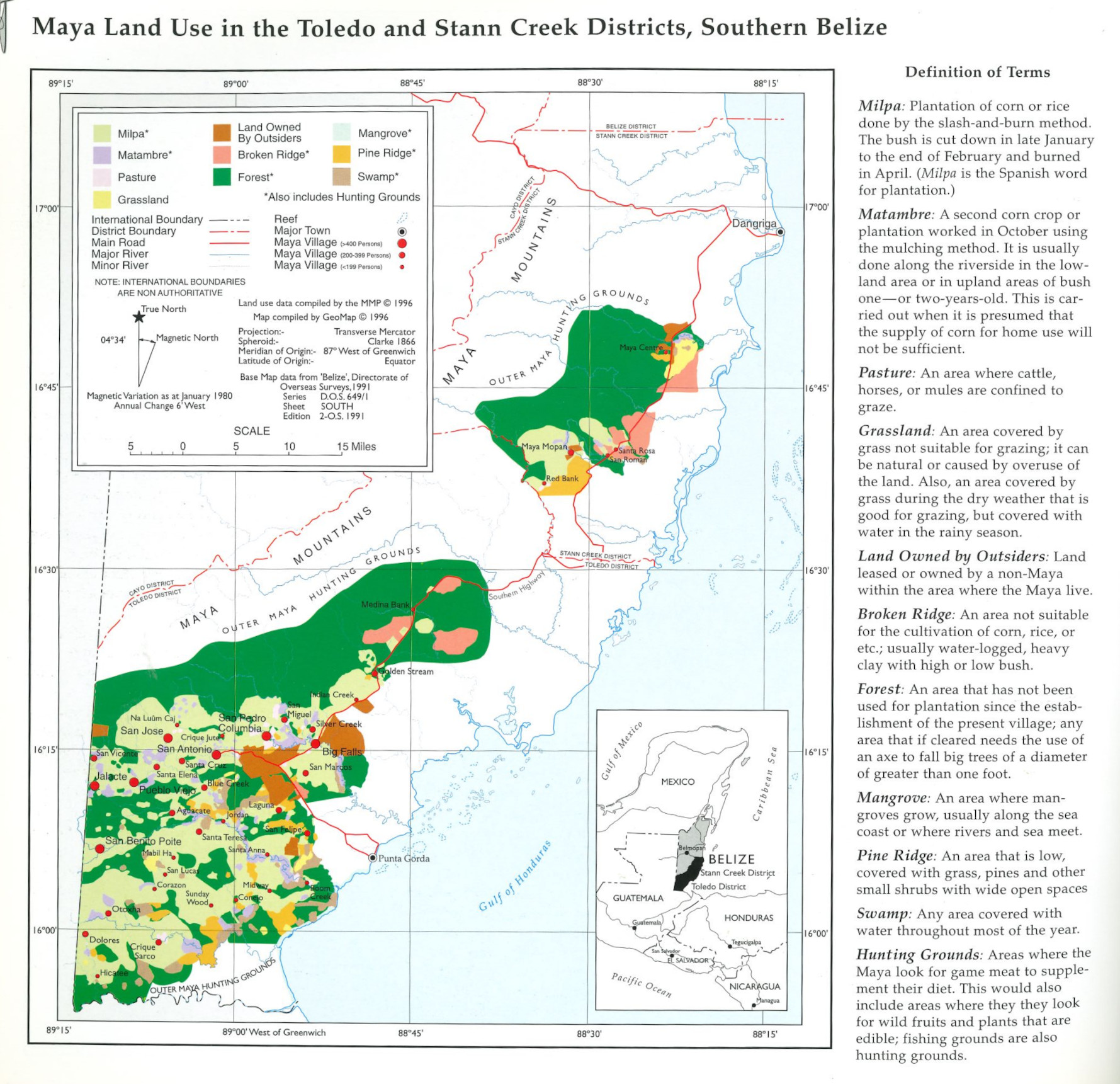
Dispossesions in the Americas

Dispossesions in the Americas

  • Home
  • Explore
  • About
  • Authors
  • Art
  • Bodies
  • Curricula
  • Cultural Heritage
  • Maps
  • Territories
Back to Explore
Map 1997

Maya Land Use in the Toledo and Stann Creek Districts, Southern Belize

  • Indian Law Resource Center GeoMap Group, UC Berkeley and Society for the Preservation of Education and Research, Berkeley California

Published: 1997

  • Download Image

Peoples

  • MAYA

Citation

Indian Law Resource Center GeoMap Group. 1997. “Maya Land Use in the Toledo and Stann Creek Districts, Southern Belize.” In Maya Atlas: The Struggle to Preserve Maya Land in Southern Belize, 18. Berkeley, CA: North Atlantic Books. book

  • Download Image

Reading in Spanish

Map 1997

Maya Land Use in the Toledo and Stann Creek Districts, Southern Belize

  • Indian Law Resource Center GeoMap Group, UC Berkeley and Society for the Preservation of Education and Research, Berkeley California

Published: 1997

  • Download Image
  • Download Image

Reading in Portuguese

Map 1997

Maya Land Use in the Toledo and Stann Creek Districts, Southern Belize

  • Indian Law Resource Center GeoMap Group, UC Berkeley and Society for the Preservation of Education and Research, Berkeley California

Published: 1997

  • Download Image

Peoples

  • MAYA

Citation

Indian Law Resource Center GeoMap Group. 1997. “Maya Land Use in the Toledo and Stann Creek Districts, Southern Belize.” In Maya Atlas: The Struggle to Preserve Maya Land in Southern Belize, 18. Berkeley, CA: North Atlantic Books. book

  • Download Image

Related Content

La France. Amérique Française (Guyane). Afrique Française (Illes S.te Marie, Nossi-bé, Nossi-cumba, Nossi-fali &.).

La France. Amérique Française (Guyane). Afrique Française (Illes S.te Marie, Nossi-bé, Nossi-cumba, Nossi-fali &.).

Map 1869
Buscando a Bruno [Searching for Bruno]

Buscando a Bruno [Searching for Bruno]

Artwork
Carte des provinces de Nicaragua et Costa Rica

Carte des provinces de Nicaragua et Costa Rica

Map 1764
Carte de Colombie et des Guyanes

Carte de Colombie et des Guyanes

Map 1800 - 1899
[O ateliê], sem data [The studio, undated]

[O ateliê], sem data [The studio, undated]

Artwork
Sistema guatemalteco de áreas protegidas (SIGAP) y sitios arqueológicos en 2000.

Sistema guatemalteco de áreas protegidas (SIGAP) y sitios arqueológicos en 2000.

Map 2000
Laguna

Laguna

Map 1997
Indigenous languages in Guatemala

Indigenous languages in Guatemala

Map

Dispossessions in the Americas

A project by

University of Pennsylvania

Copyright 2024

With support from

Mellon Foundation

Site design & development

Element 84

Art Credits

Indian Law Resource Center GeoMap Group. 1997. “Maya Land Use in the Toledo and Stann Creek Districts, Southern Belize.” In Maya Atlas: The Struggle to Preserve Maya Land in Southern Belize, 18. Berkeley, CA: North Atlantic Books. book

Site Pages

  • Home
  • Explore
  • About
  • Authors
  • Art
  • Bodies
  • Curricula
  • Cultural Heritage
  • Maps
  • Territories