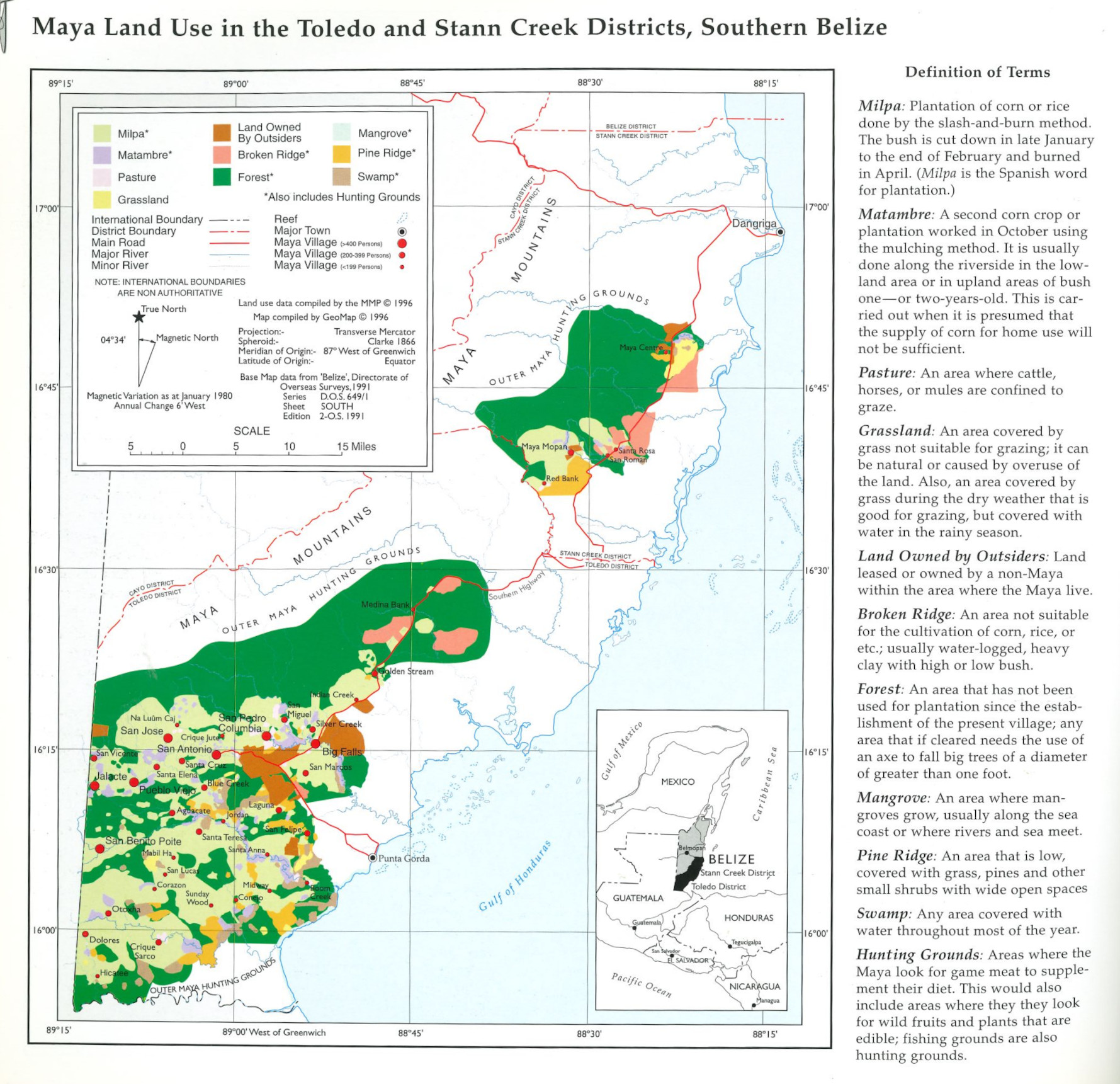
Dispossesions in the Americas

Dispossesions in the Americas

  • Home
  • Explore
  • About
  • Authors
  • Art
  • Bodies
  • Curricula
  • Cultural Heritage
  • Maps
  • Territories
Back to Explore
Map 1997

Maya Land Use in the Toledo and Stann Creek Districts, Southern Belize

  • Indian Law Resource Center GeoMap Group, UC Berkeley and Society for the Preservation of Education and Research, Berkeley California

Published: 1997

  • Download Image

Peoples

  • MAYA

Citation

Indian Law Resource Center GeoMap Group. 1997. “Maya Land Use in the Toledo and Stann Creek Districts, Southern Belize.” In Maya Atlas: The Struggle to Preserve Maya Land in Southern Belize, 18. Berkeley, CA: North Atlantic Books. book

  • Download Image

Reading in Spanish

Map 1997

Maya Land Use in the Toledo and Stann Creek Districts, Southern Belize

  • Indian Law Resource Center GeoMap Group, UC Berkeley and Society for the Preservation of Education and Research, Berkeley California

Published: 1997

  • Download Image
  • Download Image

Related Content

PRINCIPALES GRUPOS ÉTNICOS DEL TERRITORIO ESEQUIBO

PRINCIPALES GRUPOS ÉTNICOS DEL TERRITORIO ESEQUIBO

Map 1979
Jalacte

Jalacte

Map 1997
Carte de la Guyane et des territoires limitrophes (Traité d'arbitrage, signé à Londres le 6 novembre 1901)

Carte de la Guyane et des territoires limitrophes (Traité d'arbitrage, signé à Londres le 6 novembre 1901)

Map 1900 - 1999
Terra Indígena Boa Vista do Sertão Pró-Mirim

Terra Indígena Boa Vista do Sertão Pró-Mirim

Map 2012
CARTE DU THÉÂTRE DE LA GUERRE ENTRE LE BRÉSIL, LA CONFÉDÉRATION ARGENTINE, LA RÉPUBLIQUE DE L'URUGUAY & LE PARAGUAY

CARTE DU THÉÂTRE DE LA GUERRE ENTRE LE BRÉSIL, LA CONFÉDÉRATION ARGENTINE, LA RÉPUBLIQUE DE L'URUGUAY & LE PARAGUAY

Map 1864 - 1865
Indigenous provinces in El Salvador around 1500. (Adapted from Fowler 1989140-141, figure 5, with additional information from Lehman 1920:719, with modifications by the author.)

Indigenous provinces in El Salvador around 1500. (Adapted from Fowler 1989140-141, figure 5, with additional information from Lehman 1920:719, with modifications by the author.)

Map 1500
Territorios donde viven descendientes de indígenas

Territorios donde viven descendientes de indígenas

Map 2010 - 2020
PUEBLO SERI

PUEBLO SERI

Map 2020

Dispossessions in the Americas

A project by

University of Pennsylvania

Copyright 2024

With support from

Mellon Foundation

Site design & development

Element 84

Art Credits

Indian Law Resource Center GeoMap Group. 1997. “Maya Land Use in the Toledo and Stann Creek Districts, Southern Belize.” In Maya Atlas: The Struggle to Preserve Maya Land in Southern Belize, 18. Berkeley, CA: North Atlantic Books. book

Site Pages

  • Home
  • Explore
  • About
  • Authors
  • Art
  • Bodies
  • Curricula
  • Cultural Heritage
  • Maps
  • Territories