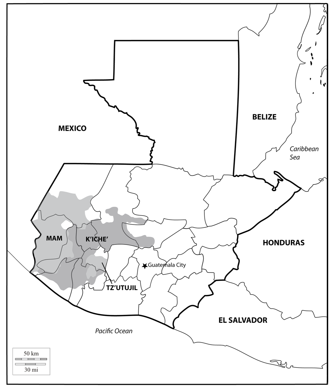
Dispossesions in the Americas

Dispossesions in the Americas

  • Home
  • Explore
  • About
  • Authors
  • Art
  • Bodies
  • Curricula
  • Cultural Heritage
  • Maps
  • Territories
Back to Explore
Map 1700

A Map of part of Yucatan or of that Part of the Eastern Shore Within the Bay of Honduras Alloted to Great Britain for the Cutting of Logwood, in consequence of the Convention Signed with Spain on the 14th July 1786.

  • William Faden

Published: 1787

  • Download Image

Peoples

  • MOSQUITO

Citation

William Faden. 1787. "A map of a part of Yucatan, or of that part of the eastern shore within the bay of Honduras allotted to Great Britain for the cutting of logwood, in consequence of the convention signed with Spain 14th July 1786." Library of Congress Geography and Map Division, G4820 1787 .F23. http://hdl.loc.gov/loc.gmd/g4820.ct008409 (top image);and William Faden. 1787. "A Map of part of Yucatan or of that Part of the Eastern Shore Within the Bay of Honduras Alloted to Great Britain for the Cutting of Logwood, in consequence of the Convention Signed with Spain on the 14th July 1786." Bibliothèque nationale de France, département Cartes et plans, GE SH 18 PF 143 DIV 2 P 3. Accessed July 12, 2023. Gallica. https://gallica.bnf.fr/ark:/12148/btv1b5970790d/f1.item.zoom (bottom image).

  • Download Image

Reading in Spanish

Map 1700

A Map of part of Yucatan or of that Part of the Eastern Shore Within the Bay of Honduras Alloted to Great Britain for the Cutting of Logwood, in consequence of the Convention Signed with Spain on the 14th July 1786.

  • William Faden

Published: 1787

  • Download Image
  • Download Image

Reading in Portuguese

Map 1700

A Map of part of Yucatan or of that Part of the Eastern Shore Within the Bay of Honduras Alloted to Great Britain for the Cutting of Logwood, in consequence of the Convention Signed with Spain on the 14th July 1786.

  • William Faden

Published: 1787

  • Download Image

Peoples

  • MOSQUITO

Citation

William Faden. 1787. "A map of a part of Yucatan, or of that part of the eastern shore within the bay of Honduras allotted to Great Britain for the cutting of logwood, in consequence of the convention signed with Spain 14th July 1786." Library of Congress Geography and Map Division, G4820 1787 .F23. http://hdl.loc.gov/loc.gmd/g4820.ct008409 (top image);and William Faden. 1787. "A Map of part of Yucatan or of that Part of the Eastern Shore Within the Bay of Honduras Alloted to Great Britain for the Cutting of Logwood, in consequence of the Convention Signed with Spain on the 14th July 1786." Bibliothèque nationale de France, département Cartes et plans, GE SH 18 PF 143 DIV 2 P 3. Accessed July 12, 2023. Gallica. https://gallica.bnf.fr/ark:/12148/btv1b5970790d/f1.item.zoom (bottom image).

  • Download Image

Related Content

Location of three ethno-linguistic groups in the highlands of Guatemala in which joint InHerit-Riecken community-participant mapping took place. Adapted from http://d-maps. com/carte.php?num_car=1717&lang=en)

Location of three ethno-linguistic groups in the highlands of Guatemala in which joint InHerit-Riecken community-participant mapping took place. Adapted from http://d-maps. com/carte.php?num_car=1717&lang=en)

Map 2000
Paraguay, ó prov. de Rio de la Plata cum regionibus adiacentibus Tucuman et Sta. Cruz de la Sierra

Paraguay, ó prov. de Rio de la Plata cum regionibus adiacentibus Tucuman et Sta. Cruz de la Sierra

Map 1633
"Territorio Indígena Cabécar de Nairi Awari"

"Territorio Indígena Cabécar de Nairi Awari"

Map 2010
San Lucas

San Lucas

Map 1997
Plan Del curso de los Rios Huallaga y Ucayali, y de la pampa del Sacramento

Plan Del curso de los Rios Huallaga y Ucayali, y de la pampa del Sacramento

Map 1790
Constitución de Territorio Mapuche  1598-1604.

Constitución de Territorio Mapuche 1598-1604.

Map 1598 - 1604
DIVISION DE CORREGIMIENTOS EN LA PROVINCIA DE SANTA FE

DIVISION DE CORREGIMIENTOS EN LA PROVINCIA DE SANTA FE

Map 1575
Guyana

Guyana

Map 1800 - 1899

Dispossessions in the Americas

A project by

University of Pennsylvania

Copyright 2024

With support from

Mellon Foundation

Site design & development

Element 84

Art Credits

William Faden. 1787. “A map of a part of Yucatan, or of that part of the eastern shore within the bay of Honduras allotted to Great Britain for the cutting of logwood, in consequence of the convention signed with Spain 14th July 1786.” Library of Congress Geography and Map Division, G4820 1787 .F23. http://hdl.loc.gov/loc.gmd/g4820.ct008409 (top image);and William Faden. 1787. “A Map of part of Yucatan or of that Part of the Eastern Shore Within the Bay of Honduras Alloted to Great Britain for the Cutting of Logwood, in consequence of the Convention Signed with Spain on the 14th July 1786.” Bibliothèque nationale de France, département Cartes et plans, GE SH 18 PF 143 DIV 2 P 3. Accessed July 12, 2023. Gallica. https://gallica.bnf.fr/ark:/12148/btv1b5970790d/f1.item.zoom (bottom image).

Site Pages

  • Home
  • Explore
  • About
  • Authors
  • Art
  • Bodies
  • Curricula
  • Cultural Heritage
  • Maps
  • Territories