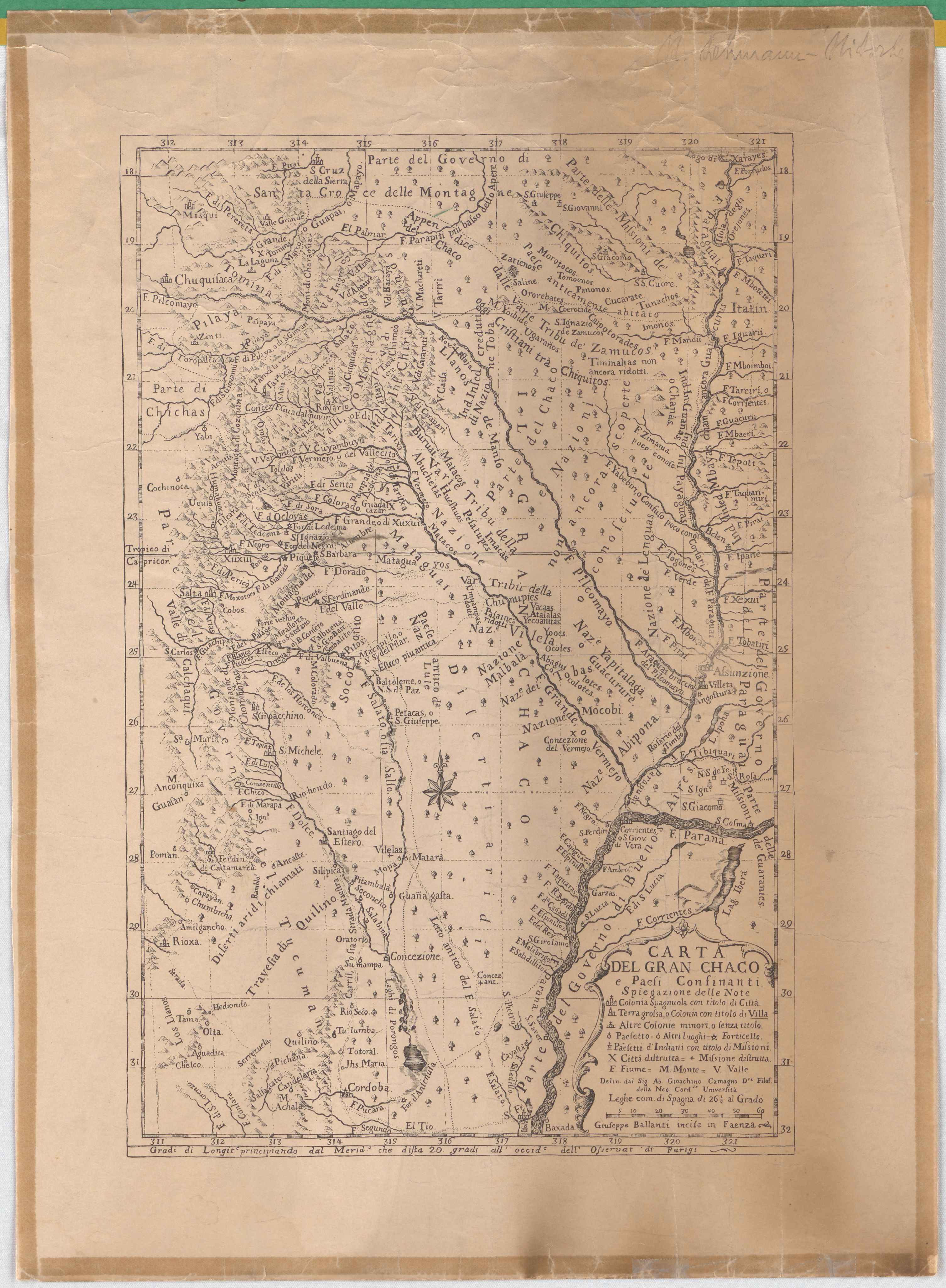
Dispossesions in the Americas

Dispossesions in the Americas

  • Home
  • Explore
  • About
  • Authors
  • Art
  • Bodies
  • Curricula
  • Cultural Heritage
  • Maps
  • Territories
Back to Explore
Map 1700 - 1767

Carta Del Gran Chaco e Paesi Confinanti

  • CAMAGNO, GIOACHINO

  • Download Image

Peoples

  • CHANAS
  • GUANAS
  • ZAMUCOS
  • PILAYA
  • TOMOEMOS
  • PANONOS
  • CUCARATE
  • TUNACHOS
  • OROREBATES
  • CAIPOTORADES
  • CHIQUITOS
  • CHIRIGUANOS
  • OCLOYAS
  • MATAGUAYOS
  • LULES
  • CHUNUPIES
  • TOBAS
  • MOCOBIES
  • ABIPONES
  • YAPITALAGUAS
  • GUAYCURUES
  • COCOLOTES
  • ABAGUILOTES
  • GUARANIES
  • MATARAES

Citation

Camagno, Gioachino. "Carta Del Gran Chaco e Paesi Confinanti." Map. 18XX. Accessed July 9, 2023. https://digital.iai.spk-berlin.de/viewer/image/630113416/1/LOG_0000/.

  • Download Image

Reading in Spanish

Map 1700 - 1767

Carta Del Gran Chaco e Paesi Confinanti

  • CAMAGNO, GIOACHINO

  • Download Image
  • Download Image

Reading in Portuguese

Map 1700 - 1767

Carta Del Gran Chaco e Paesi Confinanti

  • CAMAGNO, GIOACHINO

  • Download Image

Peoples

  • CHANAS
  • GUANAS
  • ZAMUCOS
  • PILAYA
  • TOMOEMOS
  • PANONOS
  • CUCARATE
  • TUNACHOS
  • OROREBATES
  • CAIPOTORADES
  • CHIQUITOS
  • CHIRIGUANOS
  • OCLOYAS
  • MATAGUAYOS
  • LULES
  • CHUNUPIES
  • TOBAS
  • MOCOBIES
  • ABIPONES
  • YAPITALAGUAS
  • GUAYCURUES
  • COCOLOTES
  • ABAGUILOTES
  • GUARANIES
  • MATARAES

Citation

Camagno, Gioachino. "Carta Del Gran Chaco e Paesi Confinanti." Map. 18XX. Accessed July 9, 2023. https://digital.iai.spk-berlin.de/viewer/image/630113416/1/LOG_0000/.

  • Download Image

Related Content

Fig. 1. Map of French Guiana with locations of the various Amerindian groups

Fig. 1. Map of French Guiana with locations of the various Amerindian groups

Map 1999
Carte de Colombie et des Guyanes

Carte de Colombie et des Guyanes

Map 1800 - 1899
A New Map of Mexico and Adjacent Provinces Compiled From Original Documents

A New Map of Mexico and Adjacent Provinces Compiled From Original Documents

Map 1810
Carte particulière de l'isthme de Panama golfe de Darien, côte de Carthagene, jusqu'à Ste Marthe / par le Sr d'Anville,…

Carte particulière de l'isthme de Panama golfe de Darien, côte de Carthagene, jusqu'à Ste Marthe / par le Sr d'Anville,…

Map 1730
Departamentos y municipios de mayor concentración del pueblo Arhuaco

Departamentos y municipios de mayor concentración del pueblo Arhuaco

Map 2005
A Map of the United and Independant Provinces of Venezuela and New Grenada.

A Map of the United and Independant Provinces of Venezuela and New Grenada.

Map 1800 - 1899
MAPA DE SAN PEDRO AZCAPOTZALTONGO

MAPA DE SAN PEDRO AZCAPOTZALTONGO

Map 1500 - 1599
Mapa de la Provincia y Missiones de la CompañÍa de IHS del Nuevo Reyno de Granada

Mapa de la Provincia y Missiones de la CompañÍa de IHS del Nuevo Reyno de Granada

Map 1741

Dispossessions in the Americas

A project by

University of Pennsylvania

Copyright 2024

With support from

Mellon Foundation

Site design & development

Element 84

Art Credits

Camagno, Gioachino. “Carta Del Gran Chaco e Paesi Confinanti.” Map. 18XX. Accessed July 9, 2023. https://digital.iai.spk-berlin.de/viewer/image/630113416/1/LOG_0000/.

Site Pages

  • Home
  • Explore
  • About
  • Authors
  • Art
  • Bodies
  • Curricula
  • Cultural Heritage
  • Maps
  • Territories