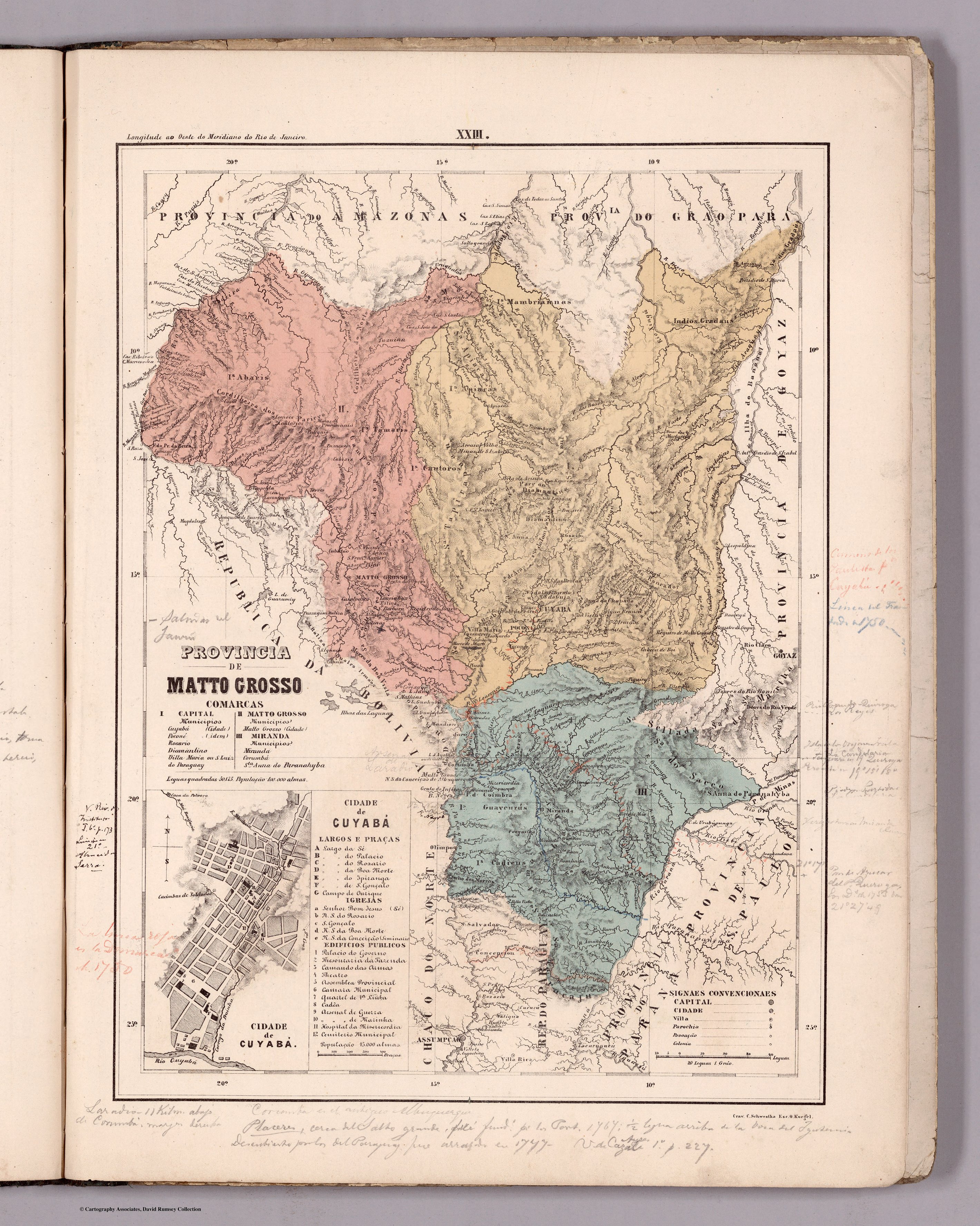
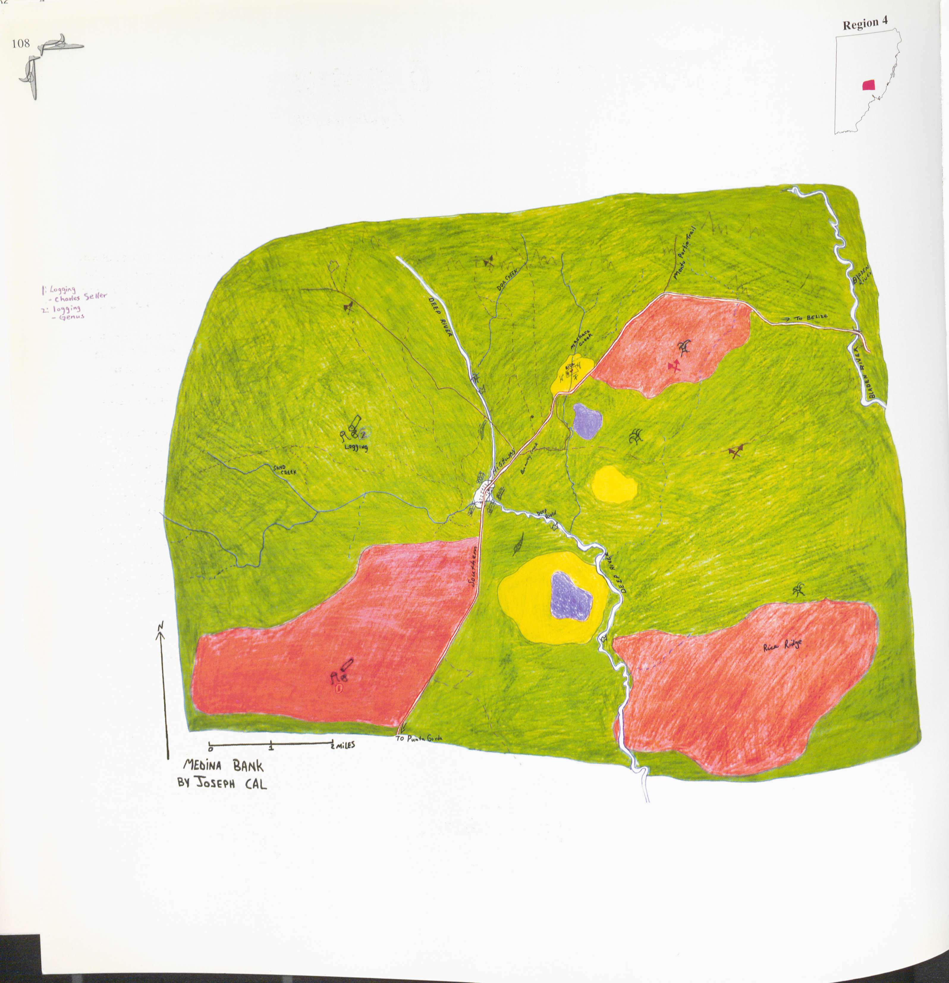
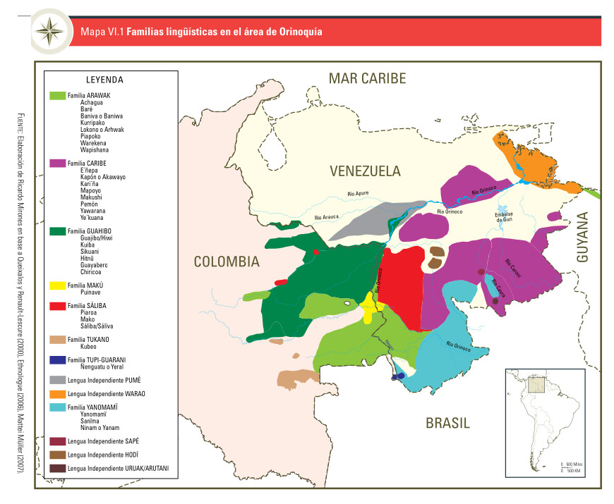
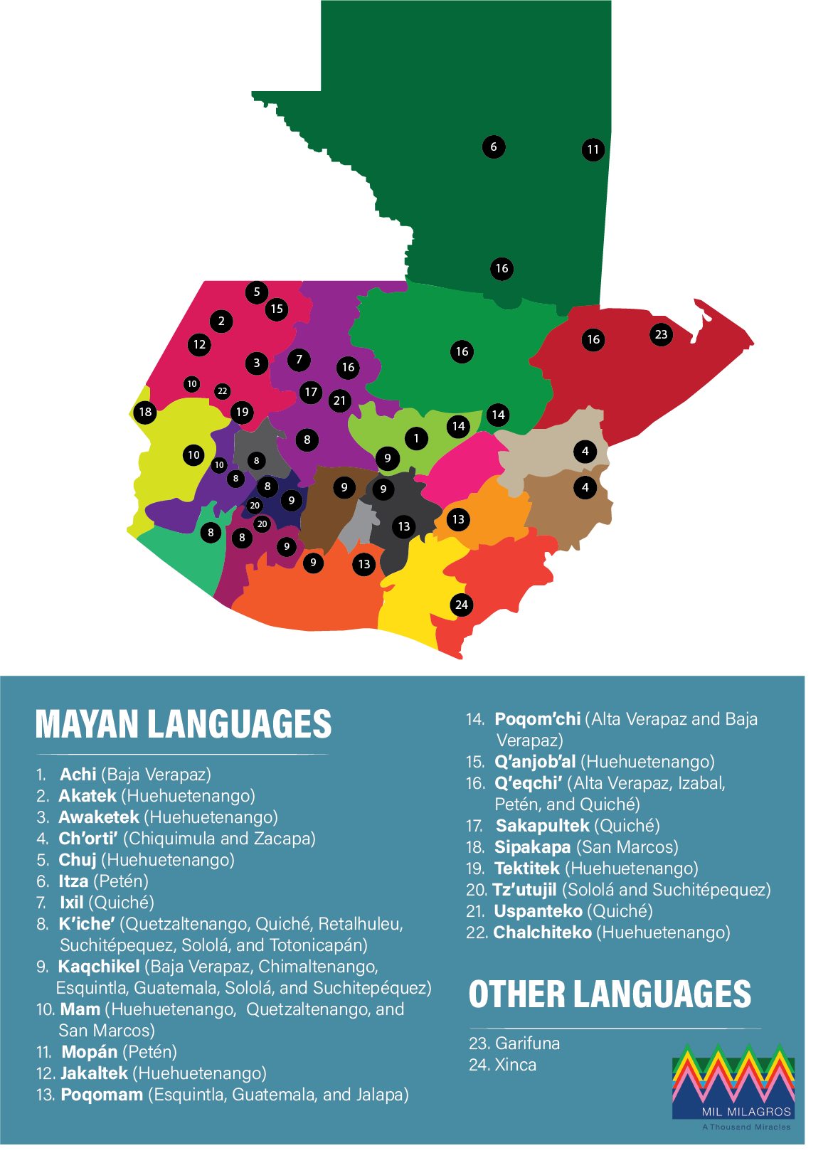
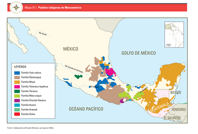
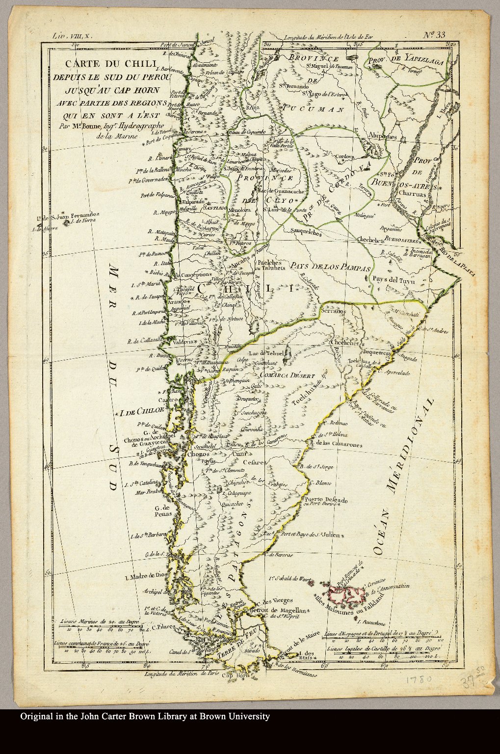
Dispossesions in the Americas

Dispossesions in the Americas

  • Home
  • Explore
  • About
  • Authors
  • Art
  • Bodies
  • Curricula
  • Cultural Heritage
  • Maps
  • Territories
Back to Explore
Map 1780

Carte du Chili depuis le sud du Perou jusqu'au Cap Horn ... par Mr. Bonne, Ingr. Hydrographe de la Marine.

  • Bonne, Rigobert

Published: 1780

  • Download Image

Peoples

  • PATAGONES
  • PUELCHES
  • PAMPAS
  • PEHUENCHES
  • TEHUELCHES
  • AUCAS
  • CHARRUAS

Citation

Bonne, Rigobert. "Carte du Chili depuis le sud du Perou jusqu'au Cap Horn ... par Mr. Bonne, Ingr. Hydrographe de la Marine." Map. 1780. Accessed April 3, 2022. https://jcb.lunaimaging.com/luna/servlet/detail/JCBMAPS~1~1~3469~101683:Carte-du-Chili-depuis-le-sud-du-Per?sort=normalized_date%2Cfile_name%2Csource_author%2Csource_title#

  • Download Image

Reading in Spanish

Map 1780

Carte du Chili depuis le sud du Perou jusqu'au Cap Horn ... par Mr. Bonne, Ingr. Hydrographe de la Marine.

  • Bonne, Rigobert

Published: 1780

  • Download Image
  • Download Image

Reading in Portuguese

Map 1780

Carte du Chili depuis le sud du Perou jusqu'au Cap Horn ... par Mr. Bonne, Ingr. Hydrographe de la Marine.

  • Bonne, Rigobert

Published: 1780

  • Download Image

Peoples

  • PATAGONES
  • PUELCHES
  • PAMPAS
  • PEHUENCHES
  • TEHUELCHES
  • AUCAS
  • CHARRUAS

Citation

Bonne, Rigobert. "Carte du Chili depuis le sud du Perou jusqu'au Cap Horn ... par Mr. Bonne, Ingr. Hydrographe de la Marine." Map. 1780. Accessed April 3, 2022. https://jcb.lunaimaging.com/luna/servlet/detail/JCBMAPS~1~1~3469~101683:Carte-du-Chili-depuis-le-sud-du-Per?sort=normalized_date%2Cfile_name%2Csource_author%2Csource_title#

  • Download Image

Related Content

PROVINCIA DE MATTO GROSSO

PROVINCIA DE MATTO GROSSO

Map 1800 - 1850
Medina Bank

Medina Bank

Map 1997
Mapa VI.1 Familias lingüísticas en el área de Orinoquía

Mapa VI.1 Familias lingüísticas en el área de Orinoquía

Map 2009
Indigenous languages in Guatemala

Indigenous languages in Guatemala

Map
PUEBLOS INDÍGENAS DE MESOAMÉRICA

PUEBLOS INDÍGENAS DE MESOAMÉRICA

Map 2009
RESGUARDO INDÍGENA DE GUAMBÍA

RESGUARDO INDÍGENA DE GUAMBÍA

Map 1981
PUEBLO IXIL

PUEBLO IXIL

Map 2020
Comunidad "Territorio Indígena General E. Mosconi Tres Paraísos" - Pueblo Wichí

Comunidad "Territorio Indígena General E. Mosconi Tres Paraísos" - Pueblo Wichí

Map 2020

Dispossessions in the Americas

A project by

University of Pennsylvania

Copyright 2024

With support from

Mellon Foundation

Site design & development

Element 84

Art Credits

Bonne, Rigobert. “Carte du Chili depuis le sud du Perou jusqu’au Cap Horn … par Mr. Bonne, Ingr. Hydrographe de la Marine.” Map. 1780. Accessed April 3, 2022. https://jcb.lunaimaging.com/luna/servlet/detail/JCBMAPS~1~1~3469~101683:Carte-du-Chili-depuis-le-sud-du-Per?sort=normalized_date%2Cfile_name%2Csource_author%2Csource_title#

Site Pages

  • Home
  • Explore
  • About
  • Authors
  • Art
  • Bodies
  • Curricula
  • Cultural Heritage
  • Maps
  • Territories