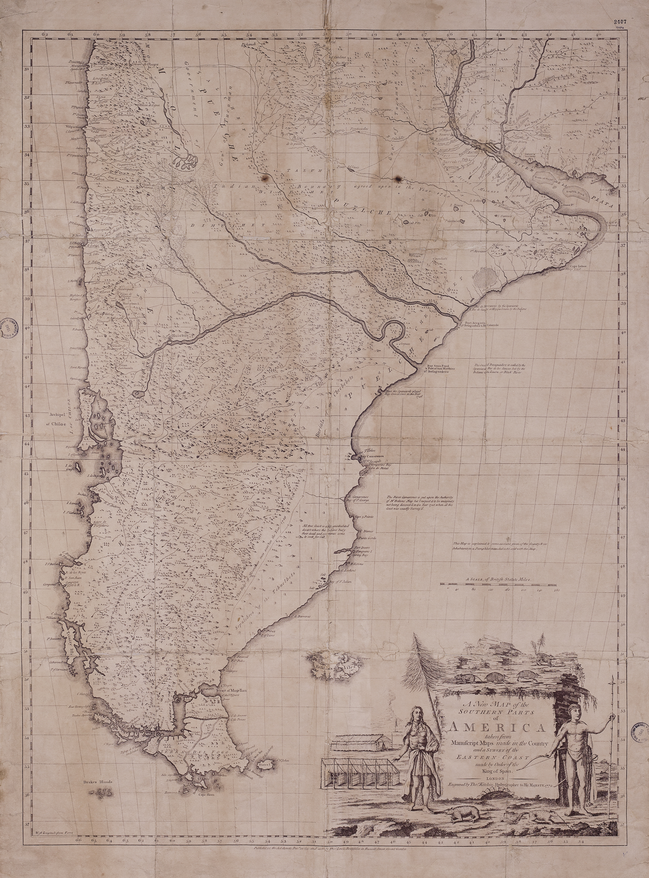
Dispossesions in the Americas

Dispossesions in the Americas

  • Home
  • Explore
  • About
  • Authors
  • Art
  • Bodies
  • Curricula
  • Cultural Heritage
  • Maps
  • Territories
Back to Explore
Map 1772

A New Map of the Southern Parts of America

  • Kitchin, Thomas.

Published: 1772

  • Download Image

Peoples

  • TEHUELCHES

Citation

Kitchin, Thomas. A New Map of the Southern Parts of America. Map. London, 1772. https://catalogo.bn.gov.ar/F/VQ97SNCH5I2DMYK22HY1G878J53C6B39XM8KPYLPVFR7KMYYKA-53482?func=full-set-set&set_number=010736&set_entry=000036&format=999

  • Download Image

Reading in Spanish

Map 1772

A New Map of the Southern Parts of America

  • Kitchin, Thomas.

Published: 1772

  • Download Image
  • Download Image

Reading in Portuguese

Map 1772

A New Map of the Southern Parts of America

  • Kitchin, Thomas.

Published: 1772

  • Download Image

Peoples

  • TEHUELCHES

Citation

Kitchin, Thomas. A New Map of the Southern Parts of America. Map. London, 1772. https://catalogo.bn.gov.ar/F/VQ97SNCH5I2DMYK22HY1G878J53C6B39XM8KPYLPVFR7KMYYKA-53482?func=full-set-set&set_number=010736&set_entry=000036&format=999

  • Download Image

Related Content

LA TERRA FERMA LA GUJANA Spagnola;Olandese;Frances;E. Portughese E La Parte Settentr le Del Bresil

LA TERRA FERMA LA GUJANA Spagnola;Olandese;Frances;E. Portughese E La Parte Settentr le Del Bresil

Map 1785
COLOMBIE;VENEZUELA;ECUADOR

COLOMBIE;VENEZUELA;ECUADOR

Map 1930
Serie Esclavas de la fiebre de oro [Series Slaves of the Golden Fever]

Serie Esclavas de la fiebre de oro [Series Slaves of the Golden Fever]

Artwork
Mapa Coro-Grafico de la Nueva Andalucia;provincias de Cumaná;y Guyana;Vertientes del Orinoco;su cierto origen;comunicación con el de las Amazonas;situación de la Laguna Parime;y nuevas Poblaciones

Mapa Coro-Grafico de la Nueva Andalucia;provincias de Cumaná;y Guyana;Vertientes del Orinoco;su cierto origen;comunicación con el de las Amazonas;situación de la Laguna Parime;y nuevas Poblaciones

Map 1778
PUEBLO AIMARA

PUEBLO AIMARA

Map 2021
Mapa de la America meridional, desde la equinoccial hasta
     la Tierra del Fuego

Mapa de la America meridional, desde la equinoccial hasta la Tierra del Fuego

Map 1596
Carte nouvelle de la France Equinoctiale faite et présentée à sa Majesté par le SieurLe Febure de la Barre son Lieutenant Généralen ces pays au mois de septembre 1665

Carte nouvelle de la France Equinoctiale faite et présentée à sa Majesté par le SieurLe Febure de la Barre son Lieutenant Généralen ces pays au mois de septembre 1665

Map 1665
Provincia del Santo Evangelio de Mexico

Provincia del Santo Evangelio de Mexico

Map 1500 - 1599

Dispossessions in the Americas

A project by

University of Pennsylvania

Copyright 2024

With support from

Mellon Foundation

Site design & development

Element 84

Art Credits

Kitchin, Thomas. A New Map of the Southern Parts of America. Map. London, 1772. https://catalogo.bn.gov.ar/F/VQ97SNCH5I2DMYK22HY1G878J53C6B39XM8KPYLPVFR7KMYYKA-53482?func=full-set-set&set_number=010736&set_entry=000036&format=999

Site Pages

  • Home
  • Explore
  • About
  • Authors
  • Art
  • Bodies
  • Curricula
  • Cultural Heritage
  • Maps
  • Territories