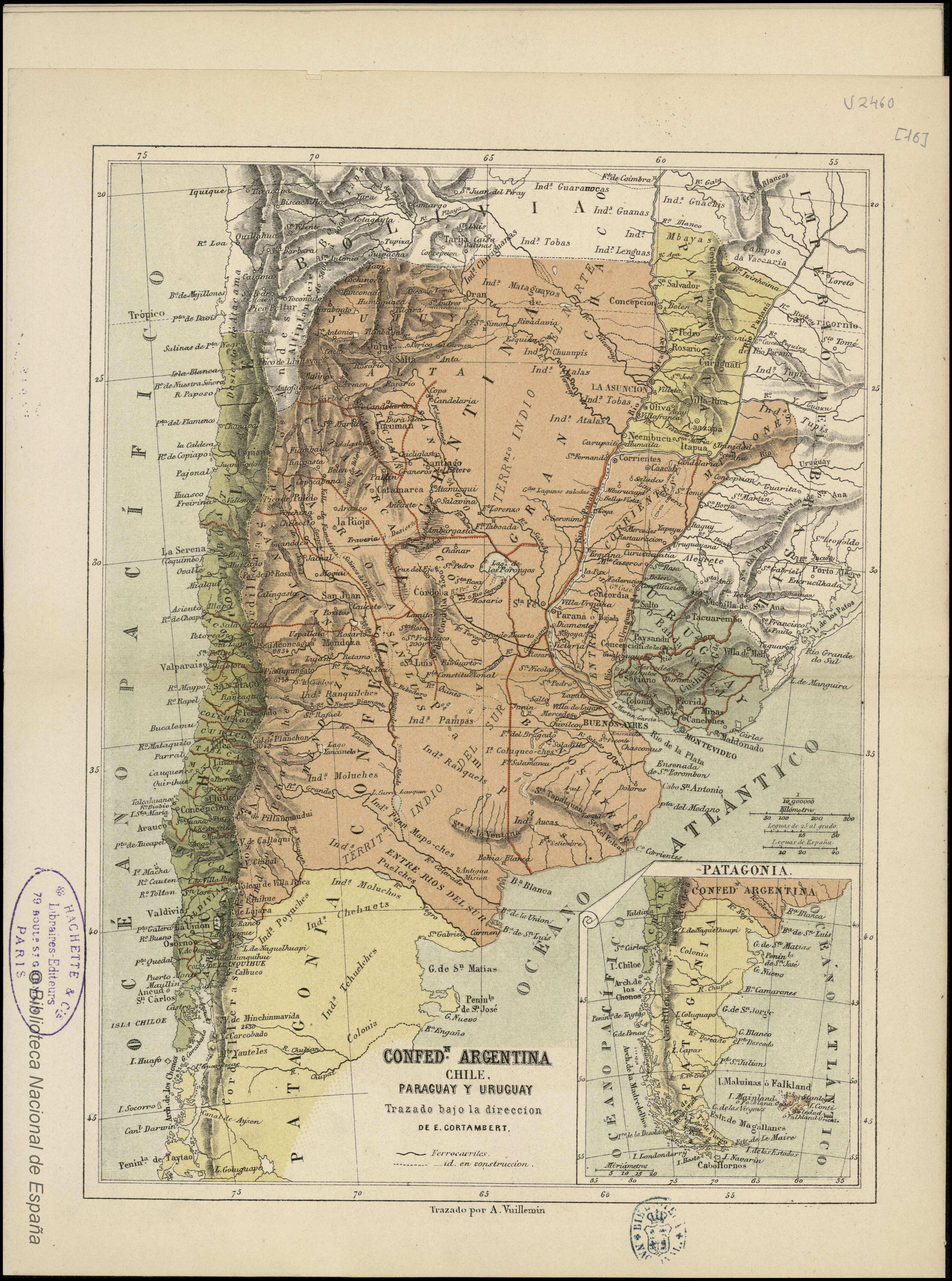
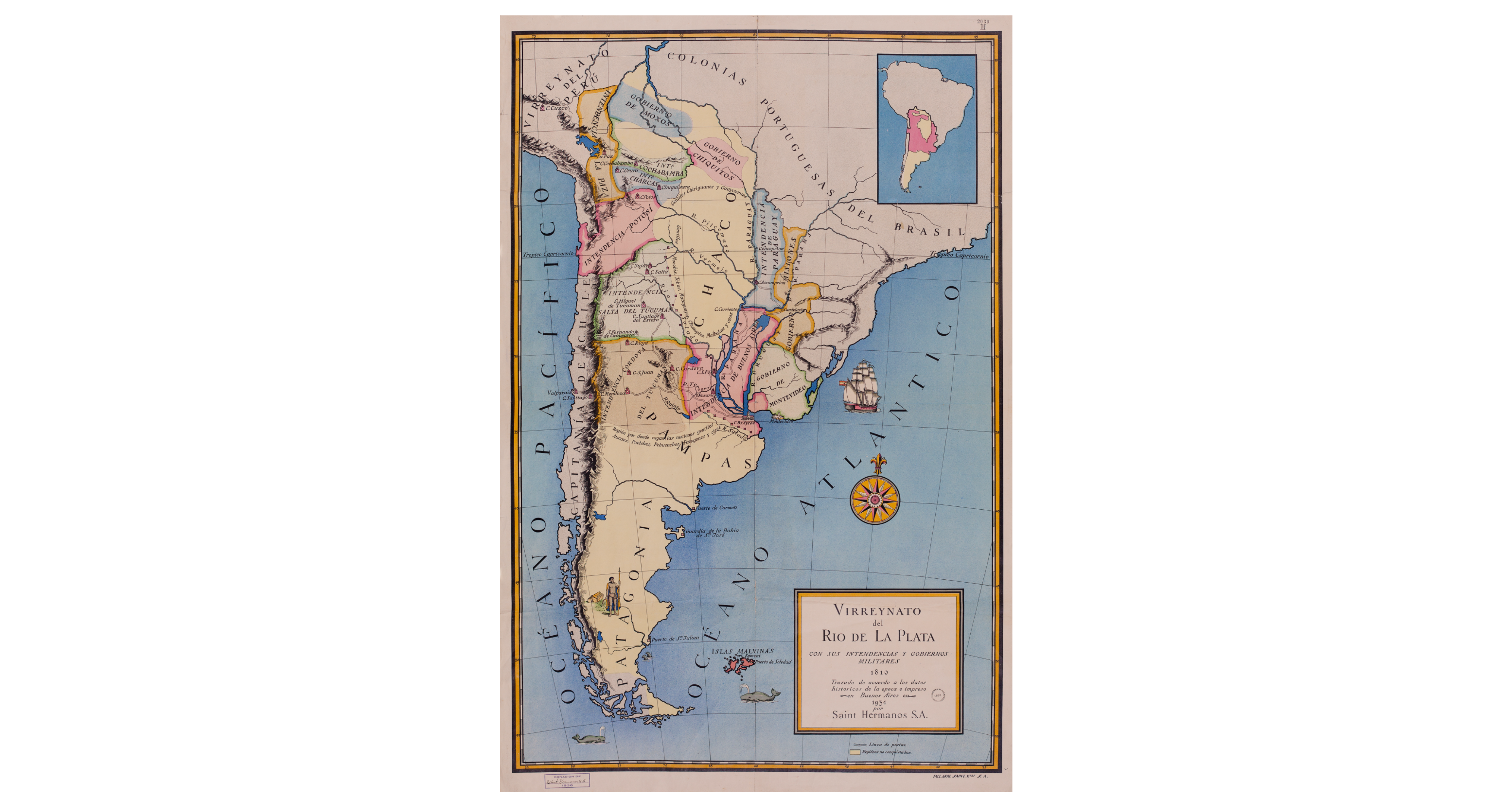
Dispossesions in the Americas

Dispossesions in the Americas

  • Home
  • Explore
  • About
  • Authors
  • Art
  • Bodies
  • Curricula
  • Cultural Heritage
  • Maps
  • Territories
Back to Explore
Map 1810

Virreynato del Río de La Plata con sus intendencias y gobiernos militares: 1810

  • Saint Hermanos

Published: 1934

  • Download Image

Peoples

  • GENTILES CHIRIGUANOS
  • GUAYCURUES
  • GENTILES
  • MOCOBIS
  • TOBAS
  • MATAGUAYOS
  • CHUNUPIES
  • MALBALAES
  • AUCAES
  • PUELCHES
  • PEHUENCHES
  • PATAGONES

Citation

SAINT HERMANOS. Virreynato del Río de La Plata con sus intendencias y gobiernos militares: 1810. Map. Buenos Aires, 1934. Accessed November 1, 2021. https://catalogo.bn.gov.ar/exlibris1/apache_media/Q5LRTHYHQ74NHTF41DPBAX9STPMVV9.jpg

  • Download Image

Reading in Spanish

Map 1810

Virreynato del Río de La Plata con sus intendencias y gobiernos militares: 1810

  • Saint Hermanos

Published: 1934

  • Download Image
  • Download Image

Related Content

IDIOMAS DE GUATEMALA Y BELICE

IDIOMAS DE GUATEMALA Y BELICE

Map
Guatimala

Guatimala

Map 1680 - 1685
Guyanes. Amér. Mérid. no. 7. (Dresse par Ph. Vandermaelen, lithographie par H. Ode. Cinquième partie. - Amer. merid. Bruxelles. 1827)

Guyanes. Amér. Mérid. no. 7. (Dresse par Ph. Vandermaelen, lithographie par H. Ode. Cinquième partie. - Amer. merid. Bruxelles. 1827)

Map 1800 - 1899
Muchitlán, Tlaxcala, Mexico

Muchitlán, Tlaxcala, Mexico

Map 1582
Partie du Mexique ou De La Nouvelle Espagne ou se trouxe L Audience de Guatimala.

Partie du Mexique ou De La Nouvelle Espagne ou se trouxe L Audience de Guatimala.

Map 1748
CONFED. ARGENTINA, CHILIE, PARAGUAY, Y URUGUAY.

CONFED. ARGENTINA, CHILIE, PARAGUAY, Y URUGUAY.

Map 1850
MAPA DE TEPETLAOZTOC

MAPA DE TEPETLAOZTOC

Map 1500 - 1599
PART OF BRAZIL

PART OF BRAZIL

Map 1904

Dispossessions in the Americas

A project by

University of Pennsylvania

Copyright 2024

With support from

Mellon Foundation

Site design & development

Element 84

Art Credits

SAINT HERMANOS. Virreynato del Río de La Plata con sus intendencias y gobiernos militares: 1810. Map. Buenos Aires, 1934. Accessed November 1, 2021. https://catalogo.bn.gov.ar/exlibris1/apache_media/Q5LRTHYHQ74NHTF41DPBAX9STPMVV9.jpg

Site Pages

  • Home
  • Explore
  • About
  • Authors
  • Art
  • Bodies
  • Curricula
  • Cultural Heritage
  • Maps
  • Territories