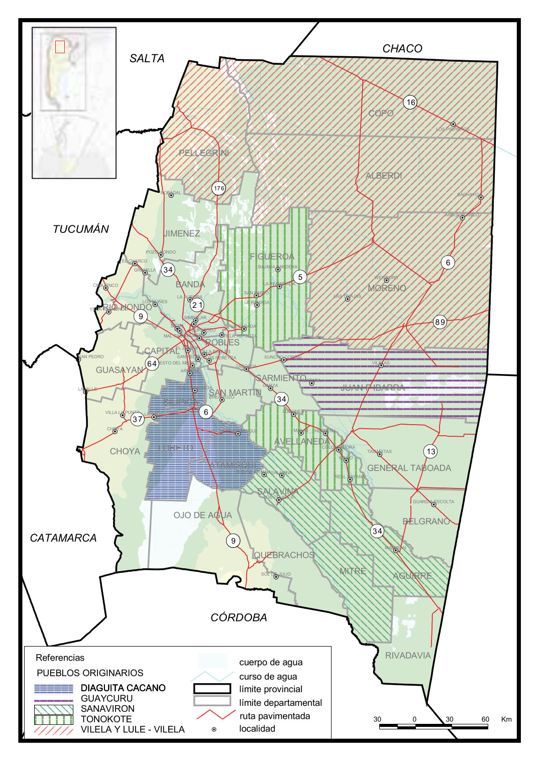
Dispossesions in the Americas

Dispossesions in the Americas

  • Home
  • Explore
  • About
  • Authors
  • Art
  • Bodies
  • Curricula
  • Cultural Heritage
  • Maps
  • Territories
Back to Explore
Map 2016

Pueblos Originarios, Santiago del Estero

  • STAGNARO, MARIANELA

Published: 2016

  • Download Image

Peoples

  • DIAGUITA CACANO
  • GUAYCURU
  • SANAVIRON
  • TONOKOTE
  • VILELA
  • LULE VILELA

Citation

Ciudad Autónoma de Buenos Aires Ministerio de Educación y Deportes de la Nación. 14 Pueblos indígenas en Santiago del Estero y Córdoba. Tejiendo memorias con relatos actuales. By Marianela Stagnaro. Edited by Ana Feder. 2016. Accessed June 8, 2021. http://www.bnm.me.gov.ar/giga1/documentos/EL005426.pdf

  • Download Image

Reading in Spanish

Map 2016

Pueblos Originarios, Santiago del Estero

  • STAGNARO, MARIANELA

Published: 2016

  • Download Image
  • Download Image

Reading in Portuguese

Map 2016

Pueblos Originarios, Santiago del Estero

  • STAGNARO, MARIANELA

Published: 2016

  • Download Image

Peoples

  • DIAGUITA CACANO
  • GUAYCURU
  • SANAVIRON
  • TONOKOTE
  • VILELA
  • LULE VILELA

Citation

Ciudad Autónoma de Buenos Aires Ministerio de Educación y Deportes de la Nación. 14 Pueblos indígenas en Santiago del Estero y Córdoba. Tejiendo memorias con relatos actuales. By Marianela Stagnaro. Edited by Ana Feder. 2016. Accessed June 8, 2021. http://www.bnm.me.gov.ar/giga1/documentos/EL005426.pdf

  • Download Image

Related Content

CARTE GÉOGRAPHIQUE, STATISTIQUE, HISTORIQUE ET POLITIQUE DU BRÉSIL

CARTE GÉOGRAPHIQUE, STATISTIQUE, HISTORIQUE ET POLITIQUE DU BRÉSIL

Map 1826
Map representing the linguistic diversity that existed in Central America and the Gulf of Fonseca at the time of contact with the Spanish

Map representing the linguistic diversity that existed in Central America and the Gulf of Fonseca at the time of contact with the Spanish

Map 1522
PUEBLO NAHUA DE JALISCO

PUEBLO NAHUA DE JALISCO

Map 2020
Areas of Indian Culture and Principal Tribes in South America

Areas of Indian Culture and Principal Tribes in South America

Map 1500 - 1900
Los Chorti: Most important minicipios, 2001

Los Chorti: Most important minicipios, 2001

Map 2001
Map of Coatlinchan, Valley of Mexico, 1578, Archivo General de la Nación, no. 1678

Map of Coatlinchan, Valley of Mexico, 1578, Archivo General de la Nación, no. 1678

Map 1578
CAMPECHE

CAMPECHE

Map 2015
Rutas de los conquistadores. Ubicacion de tribus primitivas. Primeras fundaciones.

Rutas de los conquistadores. Ubicacion de tribus primitivas. Primeras fundaciones.

Map 1500 - 1599

Dispossessions in the Americas

A project by

University of Pennsylvania

Copyright 2024

With support from

Mellon Foundation

Site design & development

Element 84

Art Credits

Ciudad Autónoma de Buenos Aires Ministerio de Educación y Deportes de la Nación. 14 Pueblos indígenas en Santiago del Estero y Córdoba. Tejiendo memorias con relatos actuales. By Marianela Stagnaro. Edited by Ana Feder. 2016. Accessed June 8, 2021. http://www.bnm.me.gov.ar/giga1/documentos/EL005426.pdf

Site Pages

  • Home
  • Explore
  • About
  • Authors
  • Art
  • Bodies
  • Curricula
  • Cultural Heritage
  • Maps
  • Territories