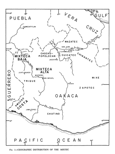
Dispossesions in the Americas

Dispossesions in the Americas

  • Home
  • Explore
  • About
  • Authors
  • Art
  • Bodies
  • Curricula
  • Cultural Heritage
  • Maps
  • Territories
Back to Explore
Map

Tribes of Chile and Northwest Argentina

    Published: 1946

    • Download Image

    Peoples

    • TARAPACA
    • AYMARA
    • CHICHA
    • LIPE
    • ATACAMA
    • DIAGUITA
    • HUARPE
    • COMECHINGON
    • PUELCHE
    • PEHUENCHE
    • ARAUCANIANS
    • MAPUCHE
    • PICUNCHE
    • HUILLICHE
    • POYAS
    • NORTHERN TEHUELCHE
    • CHILOTE
    • CHONO

    Citation

    Steward Julian Haynes, Editor. Handbook of South American Indians. Washington, U.S. G.P.O.

    • Download Image

    Reading in Spanish

    Map

    Tribes of Chile and Northwest Argentina

      Published: 1946

      • Download Image
      • Download Image

      Reading in Portuguese

      Map

      Tribes of Chile and Northwest Argentina

        Published: 1946

        • Download Image

        Peoples

        • TARAPACA
        • AYMARA
        • CHICHA
        • LIPE
        • ATACAMA
        • DIAGUITA
        • HUARPE
        • COMECHINGON
        • PUELCHE
        • PEHUENCHE
        • ARAUCANIANS
        • MAPUCHE
        • PICUNCHE
        • HUILLICHE
        • POYAS
        • NORTHERN TEHUELCHE
        • CHILOTE
        • CHONO

        Citation

        Steward Julian Haynes, Editor. Handbook of South American Indians. Washington, U.S. G.P.O.

        • Download Image

        Related Content

        Geographic Distribution of the Mixtec

        Geographic Distribution of the Mixtec

        Map 1969
        REGIÓN HUICOT O GRAN NAYAR

        REGIÓN HUICOT O GRAN NAYAR

        Map 2000
        Localización de los pueblos urus

        Localización de los pueblos urus

        Map 2014
        AMERICA MERIDIONIALE

        AMERICA MERIDIONIALE

        Map 1770
        QUERÉTARO

        QUERÉTARO

        Map 2015
        Partie Occidentale de la Terre Ferme

        Partie Occidentale de la Terre Ferme

        Map 1749
        Carte 1. Amapaya/Guyane : données d'ensemble

        Carte 1. Amapaya/Guyane : données d'ensemble

        Map 1700 - 1900
        Pueblo de Guasca

        Pueblo de Guasca

        Map 1758

        Dispossessions in the Americas

        A project by

        University of Pennsylvania

        Copyright 2024

        With support from

        Mellon Foundation

        Site design & development

        Element 84

        Art Credits

        Steward Julian Haynes, Editor. Handbook of South American Indians. Washington, U.S. G.P.O.

        Site Pages

        • Home
        • Explore
        • About
        • Authors
        • Art
        • Bodies
        • Curricula
        • Cultural Heritage
        • Maps
        • Territories