Dispossesions in the Americas

Dispossesions in the Americas

  • Home
  • Explore
  • About
  • Authors
  • Art
  • Bodies
  • Curricula
  • Cultural Heritage
  • Maps
  • Territories
Back to Explore
StoryMap 1530 - 1540

The Lienzo de Quauhquechollan (“Quauhquechollan Cloth”)

  • Williams, Charlotte

Abstract

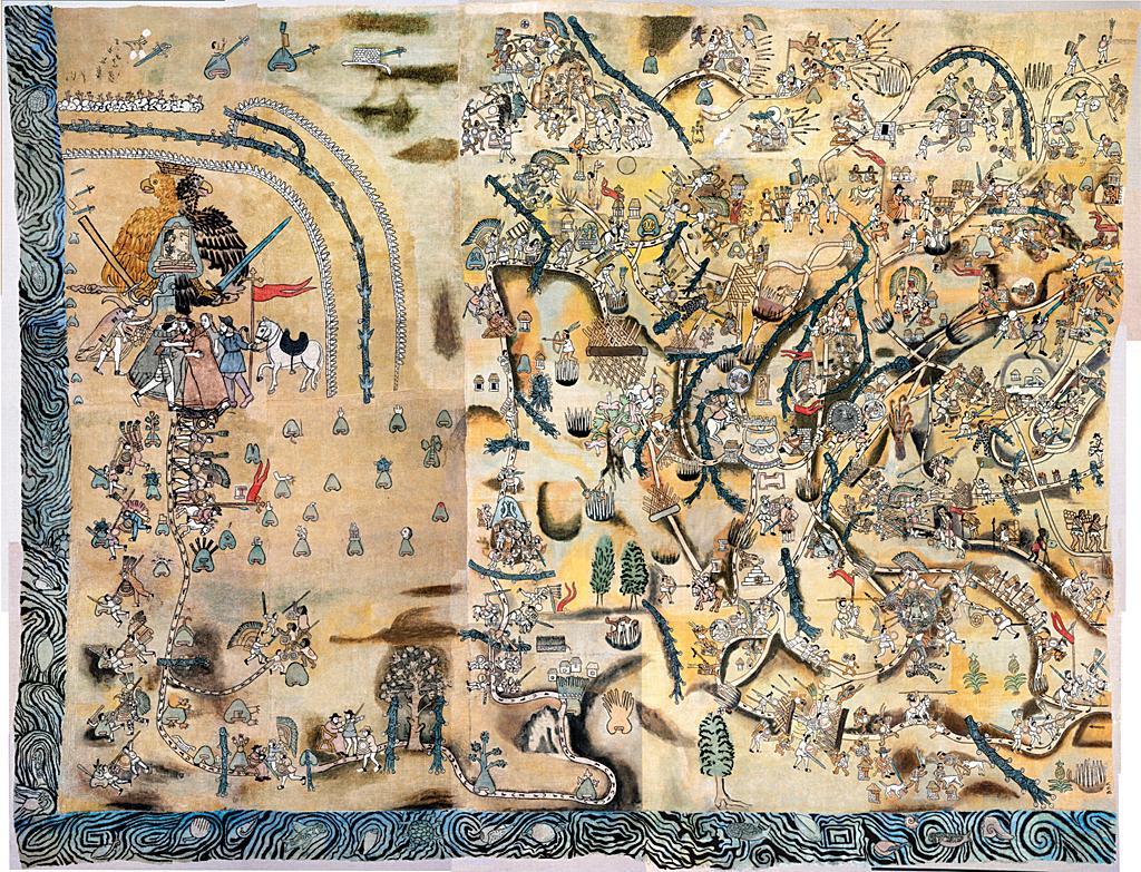
This detailed 16th century lienzo (cloth painting) was created by an anonymous Nahua chronicler from the city-state of Quauhquechollan, located in present-day Puebla, Mexico. The Lienzo is a narrative map that depicts a series of alliances, battles, and events that took place from 1527 to 1529 in Mexico and Guatemala. The events shown represent an extraordinary moment in the region’s history in which people from Quauhquechollan allied themselves with Spanish colonial forces to conquer a series of southern Maya city-states. It may also be one of the oldest surviving depictions of the territory that we now call Guatemala.

Go to StoryMap

Reading in Spanish

StoryMap 1530 - 1540

El Lienzo de Quauhquechollan

  • Williams, Charlotte

Related Content

FACSIMILE PART OF AMERICA BY DELISLE

FACSIMILE PART OF AMERICA BY DELISLE

Map 1722
CARTA COROGRÁFICA DE JALISCO, ZACATECAS Y COLIMA

CARTA COROGRÁFICA DE JALISCO, ZACATECAS Y COLIMA

Map 1824
Ethnolinguistic territories of the Californias

Ethnolinguistic territories of the Californias

Map 2007
K. GUIANA. I. DAS BRITISCHE, II. [DAS] NIEDERLAENDISCHE, III. [DAS FRANZÖSISCHE.]

K. GUIANA. I. DAS BRITISCHE, II. [DAS] NIEDERLAENDISCHE, III. [DAS FRANZÖSISCHE.]

Map 1800 - 1899
Partie du Mexique ou De La Nouvelle Espagne ou se trouxe L Audience de Guatimala.

Partie du Mexique ou De La Nouvelle Espagne ou se trouxe L Audience de Guatimala.

Map 1748
Sitios arqueológicos del Lago de Amatitlán, con lugares de ofrendas acuáticas.

Sitios arqueológicos del Lago de Amatitlán, con lugares de ofrendas acuáticas.

Map 2011
Vision etnografica del Choco Medidional

Vision etnografica del Choco Medidional

Map 1596
Indigenous provinces in El Salvador around 1500. (Adapted from Fowler 1989140-141, figure 5, with additional information from Lehman 1920:719, with modifications by the author.)

Indigenous provinces in El Salvador around 1500. (Adapted from Fowler 1989140-141, figure 5, with additional information from Lehman 1920:719, with modifications by the author.)

Map 1500

Dispossessions in the Americas

A project by

University of Pennsylvania

Copyright 2024

With support from

Mellon Foundation

Site design & development

Element 84

Site Pages

  • Home
  • Explore
  • About
  • Authors
  • Art
  • Bodies
  • Curricula
  • Cultural Heritage
  • Maps
  • Territories