Abstract
In 1665, the French gained control of Cayenne from the Dutch. The new French rule allowed the Jesuit Friars Jean Grillet and François Bechamel to embark on an expedition along the Maroni River. During their journeyings, they recorded geographical and demographical information, which was fundamental for the recognition of the territory and had a definite impact on Charles Inselin (1673-1715), who crafted a map of French Guiana in 1685.
With a more stable settlement in Cayenne after 1676, the French had the opportunity to recognize the abundant population of Guiana. The analysis of the people will become a way of organizing the territory and envisioning a plantation system.1 Most of this new data came from Grillet and Bechamel’s explorations, where they faced several Indigenous people during their expedition. Among them, the Jesuits interacted with the Acoquas, Nouragues, Galibis, Mercious, and Pirioux.2 The testimony of these encounters appeared in the memory of their journey, which materialized as a book in 1684 under the title Journal du Voyage.3
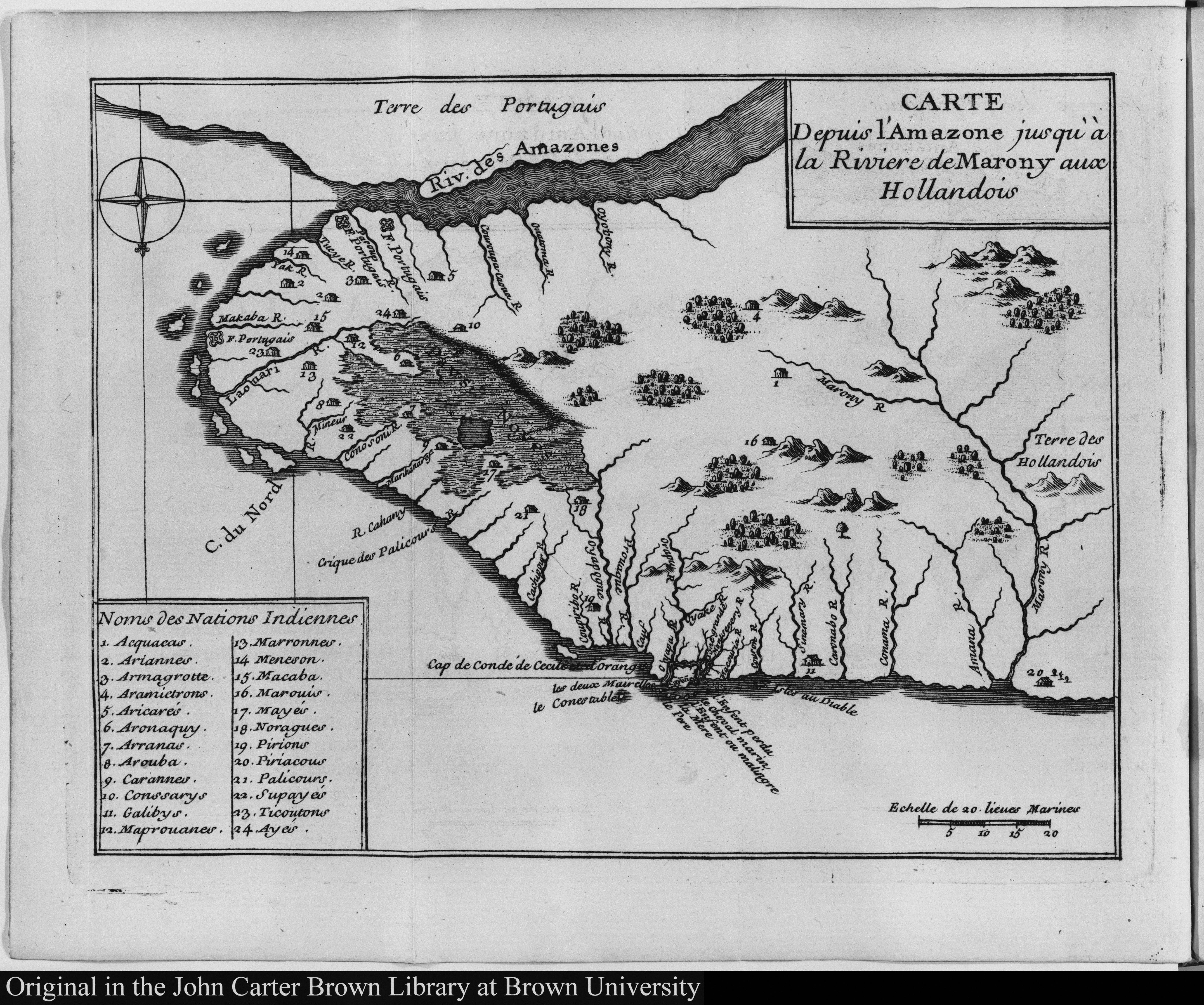
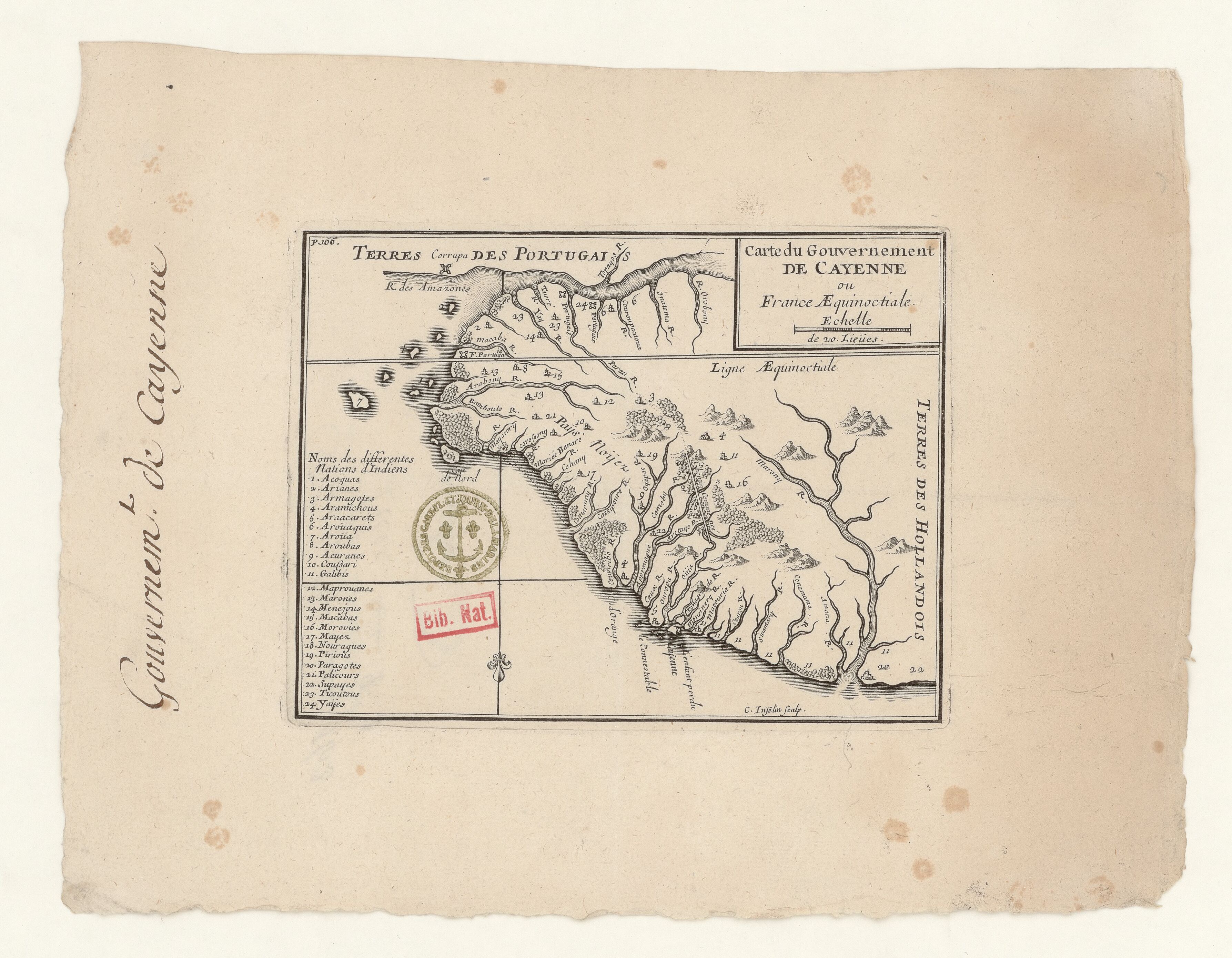
Inselin presented a South-up map of Guiana (this time called “Government of Cayenne” or Equinoctial France) with a list of twenty-four Indigenous Nations. The map offers detailed information on the location of Indigenous people living between the Maroni and the Amazon rivers.4 It will include some of the previously documented nations, such as the Arawak (Aroüaquis), Galibis, Nouragues, Pirious, Paragotes, Palicours, and Supayes, and new and lasting denominations, such as the Acoquas, Aramichous, Aroüa, Coussari, or Mayez, most of them identified by the Jesuit explorers.
The map will also include some descriptions of the geographical features. For example, the cartographer emphasizes how the region between the Oyapock and Amazon rivers used to drown under the sea. It is also interesting to see how the French saw their area of influence in Guiana from the Maroni to the Amazon River. The Portuguese and, ultimately, the Brazilian empires will contest the French territorial claim.5 Not surprisingly, the map also contemplates the location of Portuguese forts on the margins of the Amazon River. There will be several reproductions of this map, both manuscript and printed.6
Map citation:
Charles Inselin. Carte du Gouvernement de Cayenne ou France Aequinoctiale. Map, 21 x 27,5 cm. Bibliothèque Nationale de France - Gallica. Accessed July 17, 2023. https://gallica.bnf.fr/ark:/12148/btv1b53103525g
Pluchon and Abénon, Histoire des Antilles et de la Guyane, 92. ↩︎
Bernard Montabo and Elie Stephenson, La Guyane: Un Nom, Une Histoire. Tome I. Du XVIIe au XIXe siècle (Paris: Orphie, 2010), 16-17. ↩︎
There is a translation into English under the title A journal of the travels of John Grillet, and Francis Bechamel into Guiana, in the year, 1674: In order to discover the great lake of Parima, and the many cities said to be situated on its banks, and reputed the richest in the world (London: Printed for S. Buckley, 1698). Library of Congress. Accessed August 1, 2024. https://lccn.loc.gov/02009562 ↩︎
It mentions: Acoquas, Arianes, Armagotes, Aramichous, Araacates, Aroüaquis, Aroüa, Aroubas, Acuranes, Coussari, Galibis, Maprouanes, Marones, Menejous, Macabas, Morovies. Mayez, Nouragues, Pirious, Paragotes, Palicours, Supayes, Ticoutous; ↩︎
Mam-Lam-Fouck and Anakesa-Kululuka, Nouvelle Histoire De La Guyane Française, 22. ↩︎
See, for example: FGU0037, FGU0039, FGU0043, FGU0060, and FGU0087 ↩︎