Dispossesions in the Americas

Dispossesions in the Americas

  • Home
  • Explore
  • About
  • Authors
  • Art
  • Bodies
  • Curricula
  • Cultural Heritage
  • Maps
  • Territories
Back to Explore
Map Commentary 1674 - 1729

Map of French Guiana or Cayenne Government, From Cap de Nord to Maroni River. Paris, 1729

  • Ardila Gutiérrez, Javier Ricardo

Published: 2024

  • Download Image
Carte de la Guïane françoise ou du gouvernement de Caïenne depuis le Cap de Nord jusqu'àla rivière de Maroni inclusivement / par le Sr d'Anville. Gallica. Last modified: October 12, 2013. Accessed, July 15, 2023.  https://gallica.bnf.fr/ark:/12148/btv1b85967714

Carte de la Guïane françoise ou du gouvernement de Caïenne depuis le Cap de Nord jusqu’àla rivière de Maroni inclusivement / par le Sr d’Anville. Gallica. Last modified: October 12, 2013. Accessed, July 15, 2023. https://gallica.bnf.fr/ark:/12148/btv1b85967714

Abstract

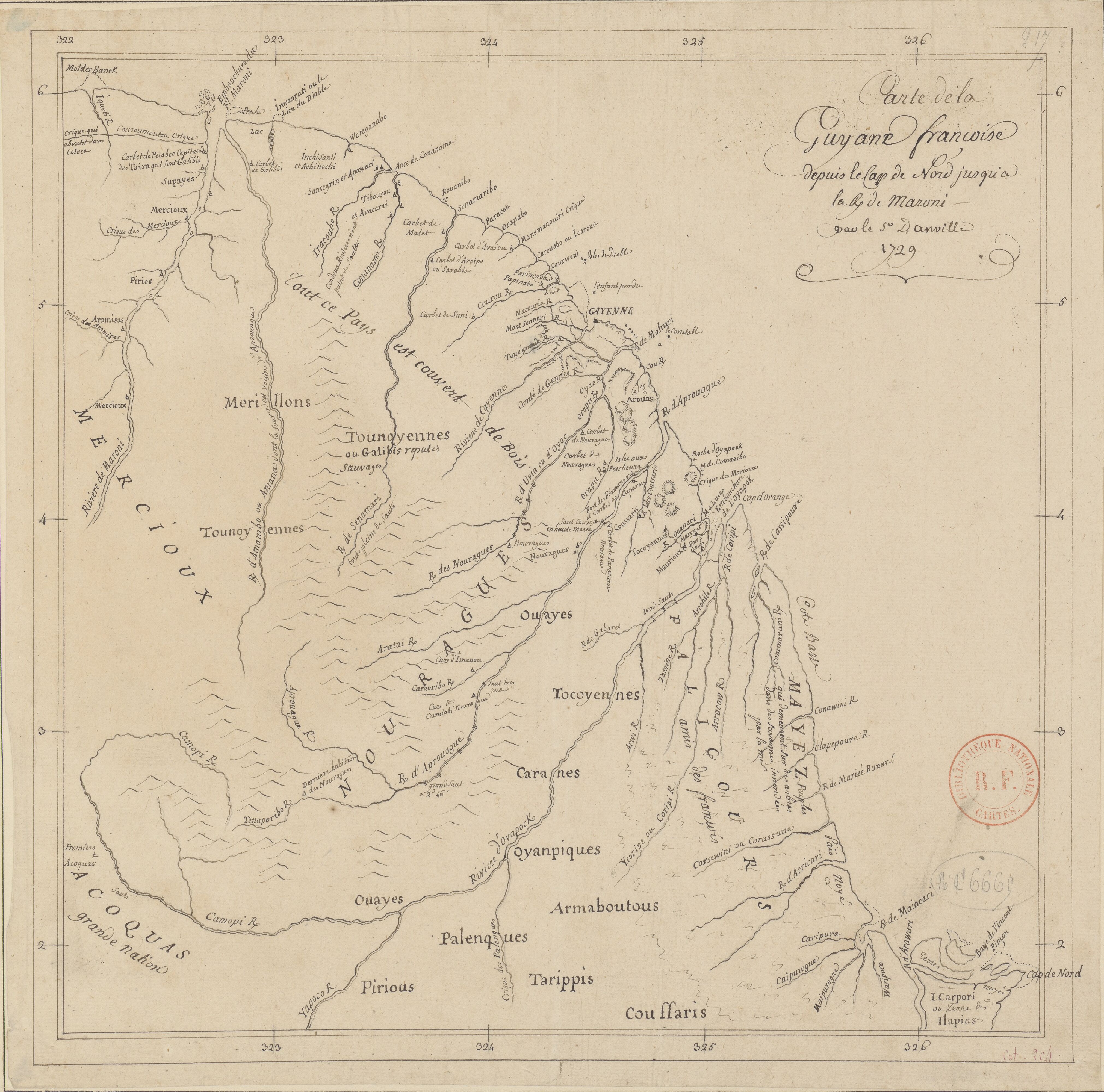
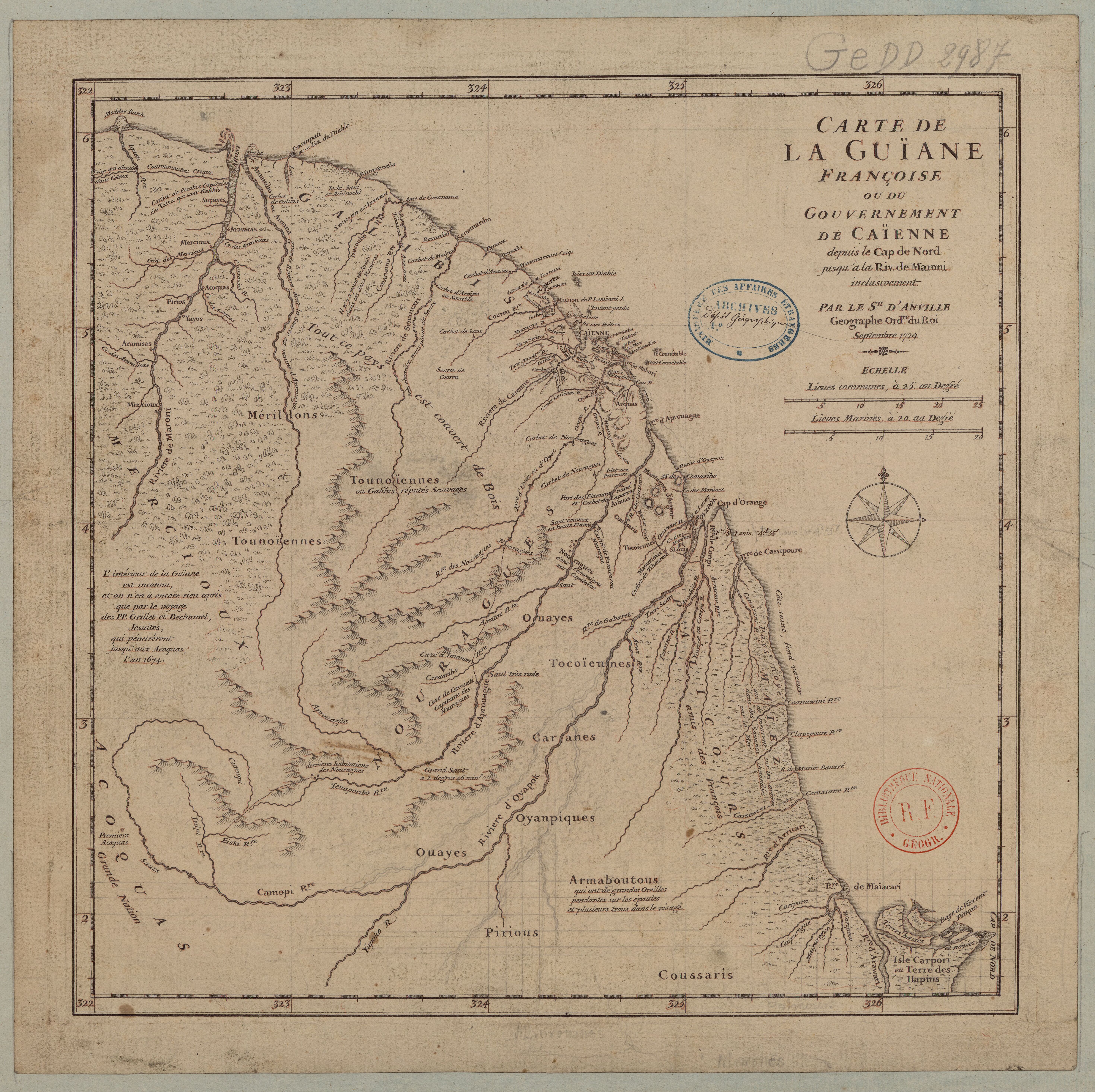
More accurate maps of French Guiana appeared after French colonial power secured its dominion in Cayenne. Their influence expanded through the coast, from the city to the Maroni River. One of the most remarkable representations of the claimed territory is the one made by the cartographer Jean-Baptiste D’Anville (1697-1782) in 1729.

The work of D’Anville contributed to the renovation of European geography and cartography. His success resulted from combining multiple sources, contrasting with first-hand testimonies, and relying on astronomical observation. D’Anville’s work took place within strong networks of patronage and scientific collaboration. He worked on weaving a robust correspondence in the Republic of Letters and contributed to journals and newspapers to increase the visibility of his cartographical and geographical studies.1

D’Anville’s 1729 map of Guiana had several reproductions, both printed and manuscript.2 The description of the Indigenous people allows us to trace their movement in the territories. It is noticeable their displacement from the Atlantic coast to the inner lands.3 Some new Indigenous people’s identifiers also appeared. The map presents the “Mérillons” (or Émérillons), a way French explorers would name the Teko people until the late 20th century. The same will be valid for the “Oyanpiques” (or Oyampis), today recognized as Wayāpi. At this point, most of the previously documented names of the Indigenous people appear on the map, such as the Acoquas, Aravacas, Armaboutous, Arouas, Coussaris, Galibis, Maïez, Mercioux, Nouragues, Palicours, Pirious, Supayes, Tocoïeunes, Tounoïennes, and Yayos. D’Anville will include three new denominations: the Aramisas, Caranes, and Ouayes.

D’Anville’s map not only offers new naming of the Indigenous people but also descriptions and commentaries. For example, the map includes comments on the physiognomy of the Indigenous people. D’Anville records how the Armaboutous (today identified as the Titiyó) used to have “long ears hanging over the shoulders and several holes on the face.”4 He also traced the movement and location of Indigenous people, as when placing the “last dwelling of the Nourages” or describing the Mayes as “those who live on the trees in the savanna drowned by the sea.” Additionally, there are several commentaries on the Indigenous people and their relations with the colonizers, such as when saying that the Tounoyennes (Wayana) and Galibis (Kali’na) are “reputed as savages;” or the Palicours (Paykweneh) are “friends of the French.”

D’Anville launched a renovation of the cartographic practice and the representation of the Earth. However, it is necessary to emphasize how most of these maps were made by someone who never left Europe. Consequently, the 1729 map includes a disclaimer recognizing how most of the available information resulted from the Jesuit exploration of 1674. Hence, cartographers such as D’Anville received updated accounts of the territory, which they contrasted with other maps and evaluated based on astronomical observations.5 His renown and celebrity as a cartographer allowed him to access fundamental materials for his works. This situation does not imply he transposed the information verbatim from the sources to his maps, but he used his knowledge to entangle the sources critically.6 Moreover, he left detailed essays about the process of crafting his maps and a deliberated purpose of abandoning doubtful information.7

Map citation:

Jean-Baptiste D’Anville. Carte de la Guïane françoise ou du gouvernement de Caïenne depuis le Cap de Nord jusqu’àla rivière de Maroni inclusivement, Map 40 x 49 cm. S.l., 1729. Bibliothèque National de France – Gallica. Accessed August 12, 2023. https://gallica.bnf.fr/ark:/12148/btv1b85967714


  1. Lucile Haguet, « Un discours de légitimation du géographe et de la géographie par la renommée et la célébrité : l’exemple de Jean-Baptiste d’Anville (1697-1782), » Revue de géographie historique 17-18 (2020), paragraphs 2, 36-44. ↩︎

  2. Each new version will include subtle differences, for example, in FGU0023, there is less information about Indigenous communities, which suggests a different purpose for the map. ↩︎

  3. The map locates the following groups: Acoquas; Aramisas; Aravacas; Armaboutous; Arouas; Caranes; Coussaris; Galibis; Maïez; Mercioux; Mérillons; Nouragues; Palicours; Pirious; Ouayes; Oyanpiques; Supayes; Tocoïeunes; Tounoïennes; Yayos ↩︎

  4. This nation has several denominations across the maps, including Aramagotos, Aramacotos, or Kirikiricotos. ↩︎

  5. Haguet, “Un discours de legitimation,” paragraph 5; Pimentel Cintra, Ferreira Furtado, “A Carte de l’Amérique Méridionale,” 295-300. ↩︎

  6. Jorge Pimentel Cintra, Júnia Ferreira Furtado, “A Carte de l’Amérique Méridionale de Bourguignon D’Anville: eixo perspectivo de uma cartografia amazônica comparada*,*” Revista Brasileira de História 31, no. 62 (December 2011): 274-277, 284-286. ↩︎

  7. Lucile Haguet, “Specifying Ignorance in Eighteenth-Century Cartography, a Powerful Way to Promote the Geographer’s Work: The Example of Jean-Baptiste d’Anville,” in The Dark Side of Knowledge: Histories of Ignorance, 1400 to 1800 edited by Cornel Zwierlein (Leiden: Brill, 2016). 373. ↩︎

Citation

Ardila Gutiérrez, Javier Ricardo. 2024. 'Map of French Guiana or Cayenne Government, From Cap de Nord to Maroni River. Paris, 1729'. Dispossessions in the Americas. https://dia.upenn.edu/en/content/FGU0044Y/

  • Download Image

Reading in Spanish

Map Commentary 1674 - 1729

Mapa del Gobierno de la Guayana Francesa o Cayena, desde el Cabo Norte hasta el río Maroni. París, 1729

  • Ardila Gutiérrez, Javier Ricardo

Published: 2024

  • Download Image
Carte de la Guïane françoise ou du gouvernement de Caïenne depuis le Cap de Nord jusqu'àla rivière de Maroni inclusivement / par le Sr d'Anville. Gallica. Last modified: October 12, 2013. Accessed, July 15, 2023.  https://gallica.bnf.fr/ark:/12148/btv1b85967714

Carte de la Guïane françoise ou du gouvernement de Caïenne depuis le Cap de Nord jusqu’àla rivière de Maroni inclusivement / par le Sr d’Anville. Gallica. Last modified: October 12, 2013. Accessed, July 15, 2023. https://gallica.bnf.fr/ark:/12148/btv1b85967714

  • Download Image

Reading in Portuguese

Map Commentary 1674 - 1729

Mapa do Governo da Guiana Francesa ou Caiena, desde o Cabo Norte até o rio Maroni

  • Ardila Gutiérrez, Javier Ricardo

Published: 2024

  • Download Image
Carte de la Guïane françoise ou du gouvernement de Caïenne depuis le Cap de Nord jusqu'àla rivière de Maroni inclusivement / par le Sr d'Anville. Gallica. Last modified: October 12, 2013. Accessed, July 15, 2023.  https://gallica.bnf.fr/ark:/12148/btv1b85967714

Carte de la Guïane françoise ou du gouvernement de Caïenne depuis le Cap de Nord jusqu’àla rivière de Maroni inclusivement / par le Sr d’Anville. Gallica. Last modified: October 12, 2013. Accessed, July 15, 2023. https://gallica.bnf.fr/ark:/12148/btv1b85967714

Resumo

Mapas mais precisos da geografia da Guiana Francesa foram produzidos depois que os franceses asseguraram seu domínio em Caiena. A influencia colonial se estendeu pela costa, desde a cidade de Caiena até o rio Maroni. Entre as representações mais notáveis do território, está a do cartógrafo Jean-Baptiste D’Anville (1697-1782), elaborada em 1729.

O trabalho de D’anville contribuiu notoriamente para a renovação da geografia e da cartografia europeia. Seu sucesso se deu principalmente à triangulação de fontes, em contraste com testemunhos de primeira mão e ao uso de observações astronômicas.

D’Anville desenvolveu seu trabalho imerso em redes sólidas de mecenato e de colaboração científica. Ele trabalhou para tecer uma sólida correspondência na República das Letras e colaborou com revistas e periódicos para aumentar a visibilidade de seus estudos. 1

O mapa de 1729 inclui a descrição de numerosos povos indígenas, o que permite rastrear sua localização e movimento dentro dos territórios. Destacam-se os deslocamentos desde a costa atlântica até as terras interioranas. 2 D’Anville incluiu informações sobre a maioria dos povos indígenas previamente documentados por viajantes e cartógrafos, tais como os Acoquas, Aravacas, Armaboutous, Arouas, Coussaris, Galibis, Maïez, Mercioux, Nouragues, Palicours, Pirious, Supayes, Tocoïeunes, Tounoïennes e Yayos. Além deles, D’Anville incluiu três novas denominações: Aramisas, Caranes e Ouayes. Também houve alguns novos identificadores, como os “Mérillons” (ou Émérillons), modo como os exploradores franceses nomearam o povo Teko até o fim do século XX. O mesmo é válido para os “Oyanpiques” (ou Oyampis), hoje conhecidos como Wayāpi. O mapa de D’Anville teve várias reproduções, tanto impressas como manuscritas. 3

D’Anville não só apresentou novos nomes para os povos indígenas como também incluiu descrições e comentários. Por exemplo, o mapa coloca observações sobre a fisionomia dos indígenas Armaboutous (hoje identificados como Titiyó) que, segundo o autor, costumavam ter “longas orelhas penduradas sobre os ombros e vários furos na cara”. 4 No mapa, D’Anville também localiza a “última morada dos Nourages” ou descreve os Mayes como “aqueles que vivem nas árvores da savana inundada pelo mar”. Esses fragmentos permitem traçar o movimento e a localização dos habitantes da Guiana. Além disso, o mapa contém comentários sobre a relação entre os povos indígenas e os colonizadores. Por exemplo, D’Anville assinala que os Tounoennes (Wayana) e os Galibis (Kali’na) têm “reputação de selvagens”; ou que os Palicours (Paykweneh) são “amigos dos franceses”.

D’Anville impulsionou uma renovação na prática cartográfica e de representação da Terra. Entretanto, é necessário ressaltar que esses mapas foram realizados por alguém que nunca saiu da Europa, dessa forma, o mapa de 1729 inclui uma cláusula em que o autor reconhece que a maior parte da informação resultou da exploração dos jesuítas em 1674. O renome e a notoriedade permitiu o acesso de pessoas como D’Anville a materiais fundamentais para seus trabalhos. Essa situação não implicou em uma reprodução textual da informação, mas sim a utilização dos conhecimentos para entrelaçar as fontes de maneira crítica. 5 Dessa maneira, cartógrafos como D’Anville receberam relatos do território, que contrastaram com outros mapas e avaliaram com base em observações astronômicas.6 É importante sinalizar que D’Anville publicou ensaios sobre o processo de elaboração de seus mapas, nos quais se destacam sua rejeição a informações duvidosas. 7

Referência do mapa:

Jean-Baptiste D’Anville. Carte de la Guïane françoise ou du gouvernement de Caïenne depuis le Cap de Nord jusqu’àla rivière de Maroni inclusivement, Map 40 x 49 cm. S.l., 1729. Bibliothèque National de France – Gallica. Acesso em : 12 de agosto de 2023. https://gallica.bnf.fr/ark:/12148/btv1b85967714


  1. Lucile Haguet, « Un discours de légitimation du géographe et de la géographie par la renommée et la célébrité : l’exemple de Jean-Baptiste d’Anville (1697-1782), » Revue de géographie historique 17-18 (2020), parágrafo 2, 36-44. ↩︎

  2. O mapa localiza os seguintes grupos indígenas: Acoquas; Aramisas; Aravacas; Armaboutous; Arouas; Caranes; Coussaris; Galibis; Maïez; Mercioux; Mérillons; Nouragues; Palicours; Pirious; Ouayes; Oyanpiques; Supayes; Tocoïeunes; Tounoïennes; Yayos. ↩︎

  3. Cada versão insere diferenças sutis, por exemple, no FGU0023, tem menos informação sobre as comunidades indígenas, o que sugere um propósito diferente para o mapa. ↩︎

  4. Essa nação tem varias denominações nos mapas, incluindo Aramagotos, Aramacotos, or Kirikiricotos. ↩︎

  5. Jorge Pimentel Cintra, Júnia Ferreira Furtado, “A Carte de l’Amérique Méridionale de Bourguignon D’Anville: eixo perspectivo de uma cartografia amazônica comparada*,*” Revista Brasileira de História 31, no. 62 (Dezembro 2011): 274-277, 284-286. ↩︎

  6. Haguet, “Un discours de legitimation,” párrafo 5; Pimentel Cintra, Ferreira Furtado, “A Carte de l’Amérique Méridionale,” 295-300. ↩︎

  7. Lucile Haguet, “Specifying Ignorance in Eighteenth-Century Cartography, a Powerful Way to Promote the Geographer’s Work: The Example of Jean-Baptiste d’Anville,” en The Dark Side of Knowledge: Histories of Ignorance, 1400 to 1800 edited by Cornel Zwierlein (Leiden: Brill, 2016). 373. ↩︎

Citation

Ardila Gutiérrez, Javier Ricardo. 2024. 'Mapa do Governo da Guiana Francesa ou Caiena, desde o Cabo Norte até o rio Maroni'. Dispossessions in the Americas. https://dia.upenn.edu/pt/content/FGU0044Y/

  • Download Image

Related Content

Carte de la Guyane françoise depuis le cap de Nord jusqu'à la R. de Maroni, par le S.r D anville

Carte de la Guyane françoise depuis le cap de Nord jusqu'à la R. de Maroni, par le S.r D anville

Map 1729
Carte de la Guïane françoise ou du gouvernement de Caïenne depuis le Cap de Nord jusqu'àla rivière de Maroni inclusivement.

Carte de la Guïane françoise ou du gouvernement de Caïenne depuis le Cap de Nord jusqu'àla rivière de Maroni inclusivement.

Map 1729

Dispossessions in the Americas

A project by

University of Pennsylvania

Copyright 2024

With support from

Mellon Foundation

Site design & development

Element 84

Art Credits

Carte de la Guïane françoise ou du gouvernement de Caïenne depuis le Cap de Nord jusqu’àla rivière de Maroni inclusivement / par le Sr d’Anville. Gallica. Last modified: October 12, 2013. Accessed, July 15, 2023. https://gallica.bnf.fr/ark:/12148/btv1b85967714

Site Pages

  • Home
  • Explore
  • About
  • Authors
  • Art
  • Bodies
  • Curricula
  • Cultural Heritage
  • Maps
  • Territories