Abstract
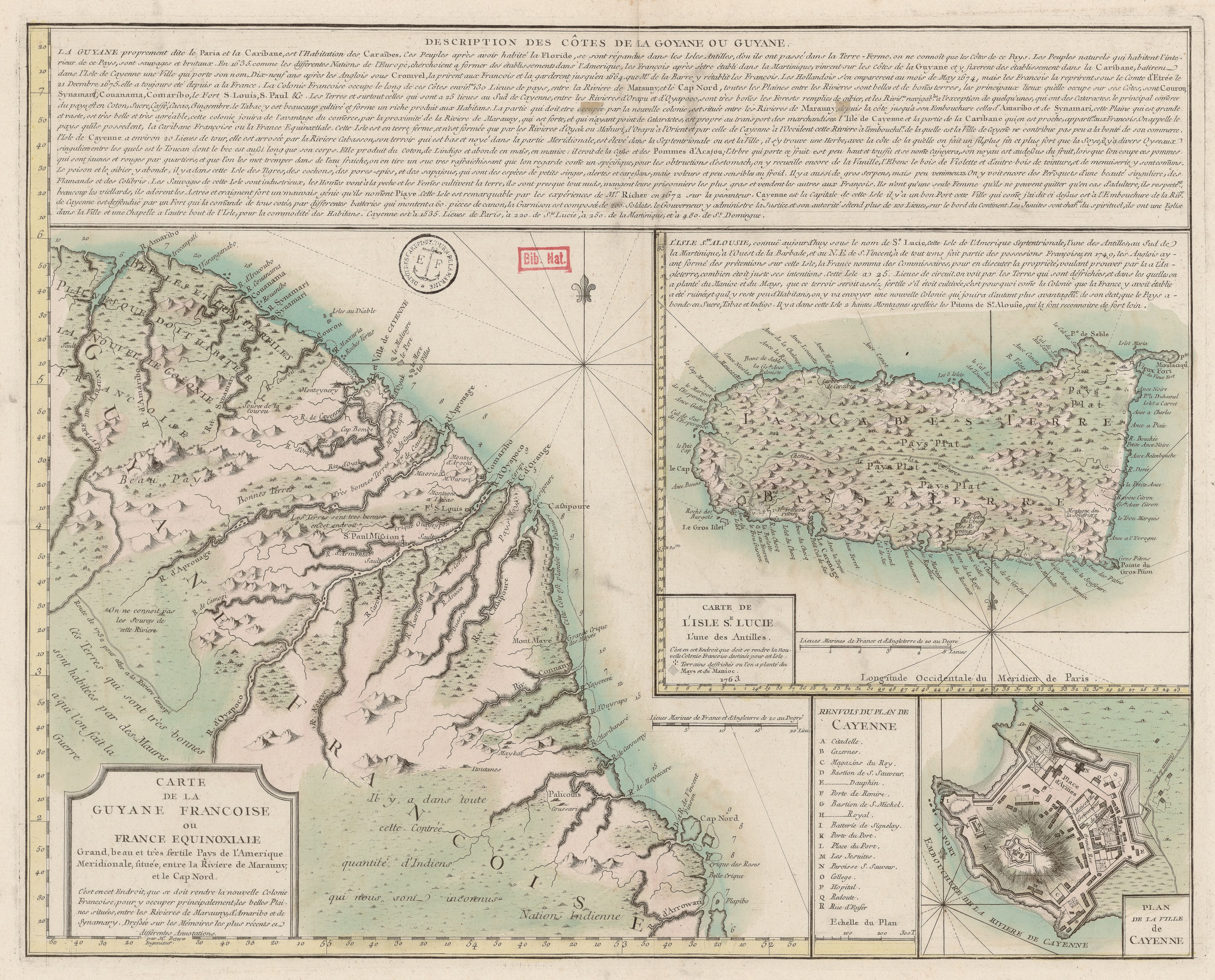
In 1764, the Engineer Beteow crafted a map of French Guiana “upon the most recent memoirs.” It was part of an ambitious propaganda campaign to populate the northwestern part of the colony with European migration. By the 18th century, French Guiana was way behind the Antilles colonies in economic and demographic numbers. If before the French Revolution, Saint Domingue (175,000,000), Martinique (27,000,000), and Guadeloupe (25,000,000) produced significant wealth in colonial exportation pounds, French Guiana’s numbers were remarkably modest (600,000). The population was also low. Its 12,673 inhabitants, by 1789, were very far from those number of Saint Domingue (523,803), Martinique (99,284), or Guadalupe (106,593).1
Still, the success of the Jesuit missions by the rivers of Guiana since the beginning of the eighteenth century made the French envision the possibility of expanding the plantation system in the colony. The mission of Kourou — between the Sinnamary and Macouria rivers — would be the model for a new organization in French Guiana’s economy. The enthusiasm increased in the following years, and in 1762, the Duke of Choiseul, Minister of Marina, launched an ambitious plan for a massive migration of Europeans to the colony.2
Beteow’s map was part of the project’s propaganda. It includes a narrative about the colony’s history and its current state. The description emphasizes how the new colony should be situated between the Maroni and the Sinnamary rivers.3 It is noticeable how this “[b]eautiful and very fertile plains that the new French colony should inhabit” lacks any reference to Indigenous people. The representation differs from time maps of the region, which show a concentration of Indigenous peoples in the area.4 Beteow does represent Indigenous people, but he locates them on the opposite side of the colony. The cartographer notes the presence of Palicouis (Palikweneh), Ioutane, Coussaris, and Maykat (Mayez) People. He also adds a brief commentary arguing that “[t]here is a quantity of Indians in the Region that is unknown to us.”
However, if the graphical depiction makes the Indigenous people on the Atlantic coast invisible, the textual narrative takes another route. Notably, the narrative begins by saying that the Guiana is the land of the Caribe people. It states thus:
Guiana, properly said the Paria and the Caribana, is the dwelling of the Caribe people. This people, after inhabiting Florida, moved to the Antilles, from where they passed to Terra-Ferme, we knew them in the costs of this country. The Native People that live in the interior of this country are savage and brutal.5
A description of the economic and cultural practices enriches this narrative about the Caribe people’s migration. When referring to the Indigenous population that remained on the Island of Cayenne, the narrator says:
The savages of this island are very industrious, the men go to fish and the women cultivate the land, they are almost entirely naked, eat their fattest prisoners and sell the others to the French. They only have one wife, who can leave only in case of adultery, they highly respect their elderly, adore the stars, and have a great fear of a wicked spirit they call Piaye.6
Beteow’s map includes another significant variation in contrast to precedent maps. In Inselin’s map, for example, Cayenne was an empty island “open” to the French intervention Map of the Government of Cayenne or Equinoctial France. S.l., 1685 . The French took control of the island after the treaty with the Galibi (Kali’na).7 This new circumstance allowed Beteow to emphasize Cayenne’s military importance. Textual and graphical narratives will join in this intention, presenting the number of soldiers, cannons, defenses, and the judiciary system.8 One reason could be the precedents of Cayenne as a contested point for the British, the Dutch, and the French, as the narrative delivers in a brief historical sketch.9 Another reason could be the same Indigenous population, already described as brutal and savage, or even the Maroon people, expressed as those who “make us war.” Anyhow, Cayenne will become not only the hint of a “civilized” space (with a hospital, school, churches, and a port city in contact with the European world) but also a synonym of French military power, a safe place to face and safeguard the population from inner and outer enemies. It will be a guarantee for embarking on the project of colonizing Kourou.
Map citation:
Beteow (engraver*). Carte de la Guyane Francoise ou France Equinoxiale. Grand, beau et très fertile Pays de l’Amerique Meridionale, située entre la Riviere de Marauny et le Cap Nord*. Map, 36 x 47 cm. Paris, 1763. Bibliothèque Nationale de France - Gallica. Accessed August 12, 2023. https://gallica.bnf.fr/ark:/12148/btv1b53103843j
Pierre Pluchon and Lucien-René Abénon, Histoire des Antilles et de la Guyane (Toulouse: Privat, 1982), 267; Mam-Lam-Fouck and Anakesa-Kululuka indicates a little growth on the population from 1700 (1 752) and 1716 (2 760), to 1759 (6 048). Serge Mam-Lam-Fouck and Apollinaire Anakesa-Kululuka, Nouvelle histoire de la Guyane Française: des souverainetés amérindiennes aux mutations de la société (Matoury, Guyane: Ibis rouge, 2013), 34 ↩︎
Marion F. Godfroy, Kourou and the Struggle for a French America (Houndmills, Basingstoke, Hampshire: Palgrave Macmillan, 2015), 81-84. ↩︎
« La partie qui doit etre occupée par la nouvelle colonie, est située entre les Rivieres de Marauny, despuis la côte jusqu’à son Embouchure celles d’Amaribo et de Synamari, cette Plaine qui est grande et vaste, est très belle et très agréable, cette colonie jouira l’avantage du comērce, par la proximité de la Riviere de Marauny, qui est forte, et qui n’ayant point de Cataractes, est propre au transport des merchandises […]. » ↩︎
See, for example, FGU0044. ↩︎
« La GUYANE proprement dite la Paria et la Caribane, est l’Habitation des Caraïbes, Ces Peuples après avoir habité la Floride, se sont répandus dans les Isles Antilles, d’où ils ont passé dans la Terre-Ferme, on ne connoî que les Côtes de ce Pays. Les Peuples naturels qui habitent l’interieur de ce Pays, sont sauvages et brutaux […]. » ↩︎
« Les Sauvage de cette Isle sont industrieux, les Homēs vont à la peche et les Femēs cultivent la terre, ils sont presque tout nuds, mangent leurs prissoniers le plus gras et vendent les outres aux François. Ils n’ont qu’un seule Femme qu’ils ne peuvent quitter qu’en cas d’adultere, ils respecte.nt beaucoup les viellards, ils adorent les Astres et craignent fort un mouvais génie qu’ils nomēnt *Piaye. *» According to François Dupuy, piaye or pïjai is the way how Wayana people call their chamans. Francis Dupuy, « Dynamiques interethniques dans le haut Maroni, » in Pratiques et représentations linguistiques en Guyane. Regards croisés, edited by Isabelle Léglise and Bettina Migge (Marseille: IRD Éditions, 2008), paragraph 19. DOI: 10.4000/books.irdeditions.6936. The Father Lombard, founder of the Kourou mission, describes the piaye as “médicin,” “echantateur,” or “le chef the toutes les superstitions indiennes.” Aime Lombard, « Lettre du P. Lombard, supérieur des missionaries de la Compagnie de Jésus dans la Guyane, sur la Mission de Kourou, précédé et suive de quelques détails sur les travaux des autres missionnaires jésuites de la Guyane jusqu’à la révolution française »in Mission de Cayenne et de la Guyane française compiled by Fortuné de Montezon (Paris: Julien, Lanier, Cosnard, 1853), 231, 289 ↩︎
Mam-Lam-Fouck and Anakesa-Kululuka, Nouvelle histoire de la Guyane Française, 35-36. ↩︎
« Cayenne est la Capitale de cette Isle il y à [sic] un bon Port cette Ville qui come j’ai dit ci dessus est à l’Embouchure de la Riv.re de Cayenne est deffendue par un Fort qui la comānd de tous cotés, par differentes batteries qui montent a 60 pieces de canon, la Garnison est composée de 200 Soldats, le Gouverneur y administer la Justice et son autorité s’étend plus de 100 Lieues, sur le bord du Continent. » ↩︎
« En 1635, comme les differentes Nations de l’Europe, cherchoient [sic] a former des établissements dans l’Amerique, les François aprè s’etre étrabli dans la Martinique, vinrent sus les Côtes de la Guyane et y fixerent des établissement dans la Caribane, batirent dans l’Isle de Cayenne une Ville qui porte son nom. Dix-neuf ans après les Anglois sous Cromvel, la prirent aux Francois et la garderent jusqu’en 1664 que M.r de la Barre y rétablit les Francois. Les Hollandois s’en emparerent au mois de May 1674, mais les Francois la repirent sous le Comte d’Etrée le 21 Decembre 1675, elle a toujours eté depuis a la France […]. » ↩︎