Abstract
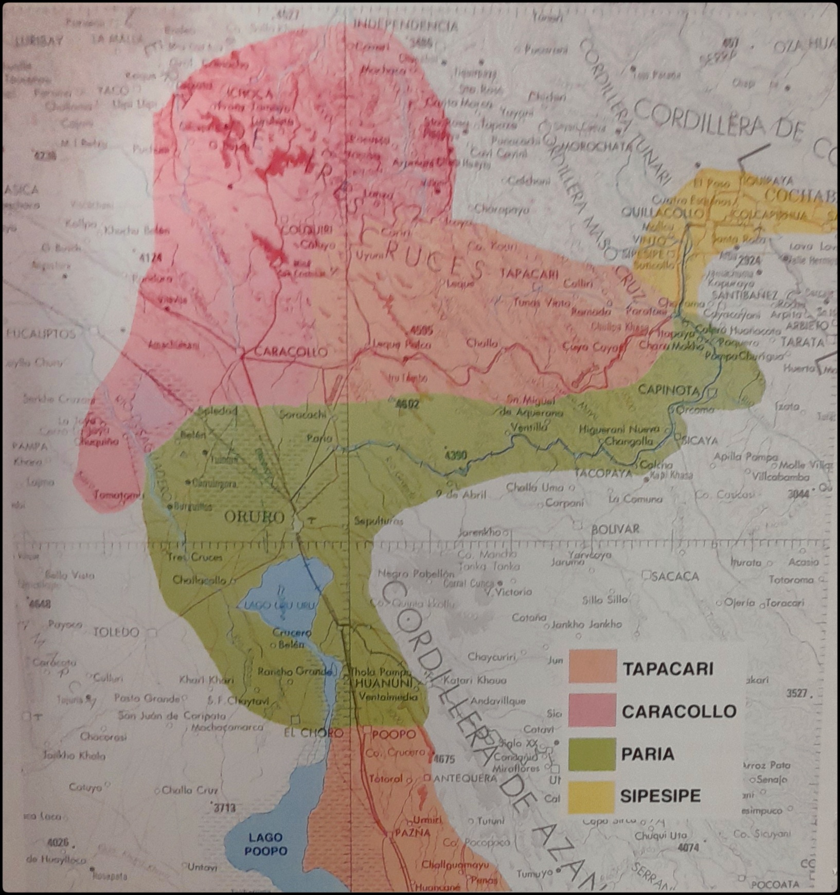
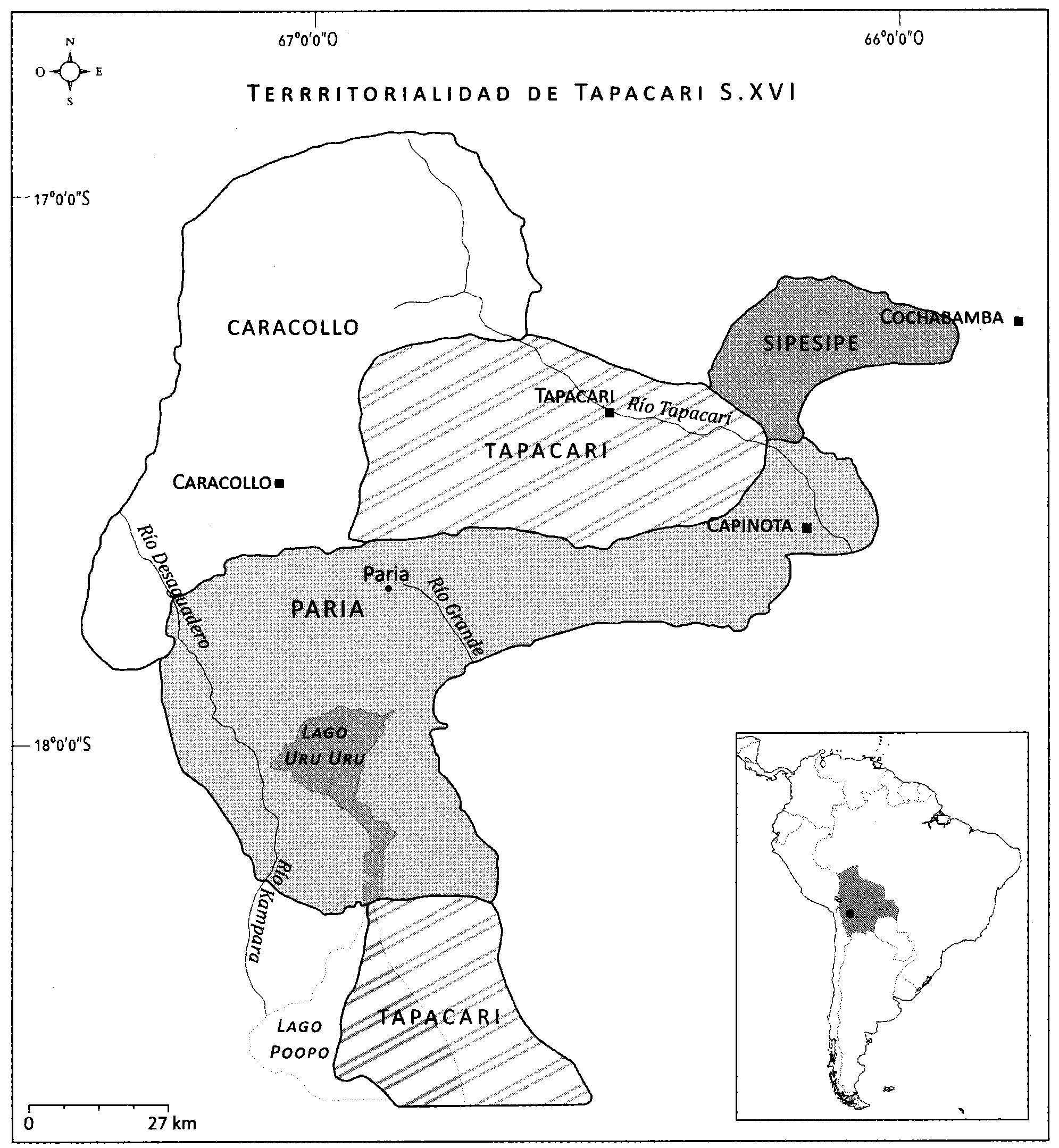
The map displays the territoriality of the four polities that made up the Sura Confederation as they were supposed to have been at the turn of the 16th century (portrayed clearly in the map.) The territories of the Aymara lordships in this part of the Andes were characterized by being non-contiguous with central settlements (cabeceras) located in the altiplano and several ethnic “islands” set in the inter-Andean valleys to the east. The case of the Sura peoples presented slight variations regarding this general model that could have derived from Inca territorial reorganization policies. The Sura territory of Sipe Sipe was entirely situated in the valleys. However, the Sura central settlement of Tapacarí was not located in the altiplano, but in the middle of the Tapacarí river valley. It is also worth noting that the altiplano settlements of the Sura population of Tapacarí were at a greater distance and more clearly spread out from their valley settlements than in the other cases.1
The territory of the Sura de Paria, probably the largest and constant, had its origin in the altiplano around Lake Uru-Uru —today completely desiccated. It had its settlement heart in Paria —a very important storage and redistribution center or tambo under the Inca state— and ran along the Arque river valley as far as Sicaya and Capinota, where the Arque river meets the Caine and Rocha rivers. It is possible, as Schramm suggests, that the central settlement may have been at Sora Sora in pre-Inca times and that the Inca state moved it to Paria along the main Inca Trail or Camino Inca.2 The Suras of Paria were structured in two subdivisions. Namely, the upper half (anansaya) section organized in six ayllus, and the lower half (urinsaya) segment arranged in 5 ayllus.3
Most of the Sura territory of Caracollo was in the altiplano north of Lake Uru-Uru with central settlements at Caracollo and Mohosa. Their valley lands covered parts of the current Ayopaya province, and were additionally shared with the Sura peoples of Tapacarí and Sipe Sipe. The Suras of Caracollo were probably also organized in two-half subdivisions organized in a total of seven ayllus, yet more research would be needed to identify which belonged to the upper half and which to the lower half sections, respectively.4
The Sura de Tapacarí had high plateau lands bordering the eastern shore of Lake Poopó, and valley lands along the Tapacarí River under their control, precisely where their main settlement was located, reaching as far as Ytapaya. They were organized in two subdivisions, the upper section was organized in six ayllus, and the lower half was divided into seven ayllus5. They also had “islands” along the warmer valleys of Ayopaya.
The territory of the Suras of Sipe Sipe was located further down the valley, covering a large part of what is currently known as the Lower Valley of Cochabamba (in the Quillacollo province). They shared this space with the Cotas, an ethnic group native to this valley, and the Urus, natives of the altiplano. The Suras of Sipe Sipe were also organized in two halves, the upper section organized in five ayllus, and the lower one structured around another five ayllus.6
REFERENCES:
del Río, Mercedes. Etnicidad, Territorialidad y Colonialismo En los Andes: Tradición y Cambio entre los Soras de Los Siglos XVI y XVII (Bolivia). La Paz: Instituto de Estudios Bolivianos, 2005.
del Río, Mercedes. “Dinastías Señoriales y Transformaciones Territoriales entre los Sura de Tapacarí S. XVI-XVII.” En Interpretando Huellas. Arqueología, Etnohistoria y Etnografía de los Andes y sus Tierras Bajas, editado por María de los Ángeles Muñoz Collazos, 391-408. La Paz: Kipus, 2018.
Schramm, Robert. “Fronteras y Territorialidad: Repartición Étnica y Política Colonizadora en los Charcas (Valles de Ayopaya y Mizque).” In Espacio, Etnias, Frontera: Atenuaciones Políticas en el Sur del Tawantinsuyu Siglos XV - XVIII, edited by Ana María Presta, 163-188. Sucre: ASUR, 1995.
Mercedes del Río, “Dinastías Señoriales y Transformaciones Territoriales entre los Sura de Tapacarí S. XVI-XVII,” en Interpretando Huellas. Arqueología, Etnohistoria y Etnografía de los Andes y sus Tierras Bajas, ed. María de los Ángeles Muñoz Collazos (La Paz: Kipus, 2018), 391-408. ↩︎
Robert Schramm, “Fronteras y Territorialidad: Repartición Étnica y Política Colonizadora en los Charcas (Valles de Ayopaya y Mizque),” in Espacio, Etnias, Frontera: Atenuaciones Políticas en el Sur del Tawantinsuyu Siglos XV - XVIII, ed. Ana María Presta (Sucre: ASUR, 1995), 163-188. ↩︎
del Río. “Dinastías Señoriales y Transformaciones Territoriales entre los Sura de Tapacarí”. ↩︎
del Río. “Dinastías Señoriales y Transformaciones Territoriales entre los Sura de Tapacarí”. ↩︎
Del Río, Etnicidad, Territorialidad y Colonialismo en los Andes: Tradición y Cambio entre los Soras de los Siglos XVI Y XVII (Bolivia), 59. ↩︎
Del Río, Etnicidad, Territorialidad y Colonialismo en los Andes: Tradición y Cambio entre los Soras de los Siglos XVI Y XVII (Bolivia), 59. ↩︎