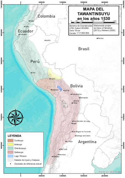
Dispossesions in the Americas

Dispossesions in the Americas

  • Home
  • Explore
  • About
  • Authors
  • Art
  • Bodies
  • Curricula
  • Cultural Heritage
  • Maps
  • Territories
Back to Explore
Map Commentary 1500 - 1599

THE AYMARA POLITY OF THE LUPAQA: COMMERCIAL DESTINIES AND VERTICALITY IN THE 16TH CENTURY

  • Medeiros, Carmen

  • Grisi, Celina

  • Sánchez Patzy, Radek

Published: 2024

  • Download Image
Domínguez, N. (2014). The "puquina" language in the early colonial southern Andes (1548-1610): A geographical analysis. Journal of Latin American Geography, 13(2), 181-206.

Domínguez, N. (2014). The “puquina” language in the early colonial southern Andes (1548-1610): A geographical analysis. Journal of Latin American Geography, 13(2), 181-206.

Abstract

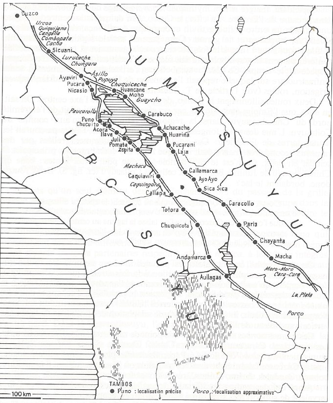
This map shows the Aymara polities AYMARA POLITIES of THE QULLASUYU in the 16th CENTURY of the Qullas, Lupaqas, and Pakaxa (Collas, Lupacas, and Pacajes) that inhabited an area of the Qullasuyu, the southern district of the Inca state or Tawantinsuyu, in the 15th and 16th centuries. The map is based on a 1585 colonial document in which the author, a Potosi mine owner, listed the tributary units established by the colonial state in the context of major reforms implemented by Viceroy Toledo in the 1570s.1 The map also shows the major Inca Road INCA ROADS AND TAMBOS in the 16th CENTURY , with the administrative centers of Ayaviri and Hatun Colla (Qulla territory), Chucuito (Lupaqa territory), and Caquiaviri (Pakaxa territory).

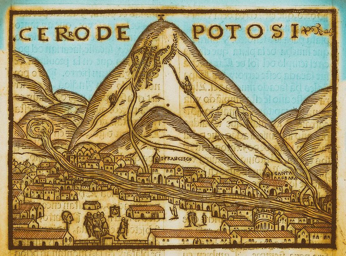
Called capitanias de mita (mita captaincies), the tributary units implemented in the second half of the 16th century were a colonial institution created to more effectively organize and manage the rotating draft labor system (called mita) for the Potosi silver mines.2 These units helped in coordinating the recruitment, transportation, and supervision of indigenous laborers. In each captaincy, the indigenous draft laborers, able men ages 18-50, were under the control of an ethnic leader, the “mita captain”, whose area of authority and jurisdiction roughly corresponded to that of a pre-Hispanic “macroethnic” Aymara polity.3

The mita system imposed quotas on different indigenous communities, requiring them to provide a certain number of laborers for specific periods. Mita captaincies facilitated the enforcement of these quotas by recruiting the labor force within their jurisdiction. This often involved coercion, as indigenous people were compelled to leave their homes and work in harsh conditions which ultimately disrupted traditional ways of life and therefore leading as well to significant demographic changes.

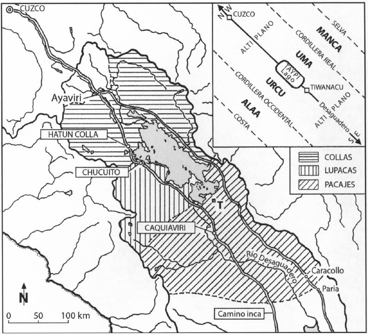
This map also contains, in the upper left corner, a diagram representing the Andean (pre-colonial and even pre-Inca) dualist conception of the space in which the space is made up of two opposite yet complementary parts (upper and lower) articulated by a middle point (taypi). Accordingly, the high plateau, i.e. the plain in between the western and eastern ranges of the Andean mountains, was divided into an upper half (urcu) and a lower (uma) half with the Titicaca Lake as the middle point.4 Urcu has masculine, dominant and phallic connotations while uma has feminine, valley, humid connotations. Following this conception, the territories of Aymara polities were organized into two halves: the upper moiety and the lower moiety.

As can be seen on the map, the territories of the Qullas and of the Pakaxa were divided into the upper half (urco moiety) and the lower half (uma moiety). The Lupaqas only occupied the upper or urco side. It is also worth noting that by the time the Spanish colonial state established the capitanias de mita, there were a significant number of Pukina speakers embedded in these tributary units controlled by aymara speaking authorities. It seems that Pukina was the language spoken in the ancient (pre-Inca) civilization of Tiwanaku; the use of this language had disappeared by the end of Spanish colonization, early 19th century. Nowadays, the majority of the population inhabiting this area of the high plateau are Aymara speakers, mostly bilingual Spanish-Aymara.

REFERENCES:

Bakewell, Peter. Miners of the Red Mountain: Indian Labor in Potosí, 1545-1650. New Mexico: University of New Mexico Press, 1984.

Bouysse-Cassagne, Thérèse. “L’espace Aymara: Urco et Uma.” Annales. Histoire, Sciences Sociales 33, no. 5–6 (December 1978): 1057–80. https://doi.org/10.3406/ahess.1978.294000.

Domínguez Faura, Nicanor. “The Puquina Language in the Early Colonial Southern Andes (1548-1610): A Geographical Analysis.” Journal of Latin American Geography 13, no. 2 (2014): 181–206.
https://doi.org/10.1353/lag.2014.0033.


  1. Nicanor Domínguez Faura, “The Puquina Language in the Early Colonial Southern Andes (1548-1610): A Geographical Analysis.” Journal of Latin American Geography 13, no.2 (2014): 181-206. ↩︎

  2. Peter. Bakewell, Miners of the Red Mountain: Indian Labor in Potosí, 1545-1650. (New Mexico: University of New Mexico Press, 1984) ↩︎

  3. Dominguez Faura, “The Puquina Language in the Early Colonial Southern Andes (1548-1610): A Geographical Analysis.”, 181-206. ↩︎

  4. Bouysse-Cassagne, “L’espace Aymara : Urco et Uma.” Annales. Histoire, Sciences Sociales 33, no. 5–6 (December 1978): 1057–80. ↩︎

Citation

Medeiros, Carmen, Celina Grisi, and Radek Sánchez Patzy. 2024. 'THE AYMARA POLITY OF THE LUPAQA: COMMERCIAL DESTINIES AND VERTICALITY IN THE 16TH CENTURY'. Dispossessions in the Americas. https://dia.upenn.edu/en/content/BOL0024Y/

  • Download Image

Reading in Spanish

Map Commentary 1500 - 1599

LOS ESTADOS AYMARAS ALREDEDOR DEL LAGO TITICACA EN LOS SIGLOS XV Y XVI

  • Medeiros, Carmen

  • Grisi, Celina

  • Sánchez Patzy, Radek

Published: 2024

  • Download Image
Domínguez, N. (2014). The "puquina" language in the early colonial southern Andes (1548-1610): A geographical analysis. Journal of Latin American Geography, 13(2), 181-206.

Domínguez, N. (2014). The “puquina” language in the early colonial southern Andes (1548-1610): A geographical analysis. Journal of Latin American Geography, 13(2), 181-206.

  • Download Image

Reading in Portuguese

Map Commentary 1500 - 1599

OS ESTADOS AIMARÁS AO REDOR DO LAGO TITICACA NOS SÉCULOS XV E XVI

  • Medeiros, Carmen

  • Grisi, Celina

  • Sánchez Patzy, Radek

Published: 2024

  • Download Image
Domínguez, N. (2014). The "puquina" language in the early colonial southern Andes (1548-1610): A geographical analysis. Journal of Latin American Geography, 13(2), 181-206.

Domínguez, N. (2014). The “puquina” language in the early colonial southern Andes (1548-1610): A geographical analysis. Journal of Latin American Geography, 13(2), 181-206.

Resumo

Este mapa mostra as polis aymaras AS POLÍTICAS AIMARÁS DO QULLASUYU NO SÉCULO XVI dos Qullas, Lupaqas e Pakaxa (Collas, Lupacas e Pacajes) que habitavam uma área do Qullasuyu, o distrito sul do Estado inca ou Tawantinsuyu, nos séculos XV e XVI. O mapa foi feito com base num documento colonial de 1585 onde o autor, proprietário de uma mina em Potosí, enumera as unidades tributárias estabelecidas pelo estado colonial no contexto das grandes reformas efetuadas pelo vice-rei Toledo, na década de 1570.1 O mapa também mostra o camino inca principal CAMINHOS INCAS E TAMBOS NO SÉCULO XVI , com os centros administrativos de Ayaviri e Hatun Colla (território Qulla), Chucuito (território Lupaqa) e Caquiaviri (território Pakaxa).

As chamadas capitanias de mita**, unidades tributárias implementadas na segunda metade do século XVI, foram uma instituição colonial criada para organizar e administrar mais eficazmente el sistema rotativo de mano de obra (chamado mita) para as minas de prata de Potosí.**2 Estas unidades ajudavam a coordenar o recrutamento, transporte e supervisão dos trabalhadores indígenas. Em cada capitania, os trabalhadores indígenas, homens fisicamente aptos, entre 18 e 50 anos de idade, estavam sob o controle de um líder étnico, o “capitão da mita”, cuja área de autoridade e jurisdição correspondia aproximadamente à de um sistema político aimará “macro-étnico” pré-hispânico. 3

O sistema de la mita impunha cotas às diversas comunidades indígenas, exigindo-lhes que contribuíssem com um determinado número de trabalhadores durante períodos específicos. As capitanias de mita facilitavam o cumprimento destas cotas recrutando a mão de obra de sua jurisdição. Isso, com frequência, implicava coerção, já que os indígenas eram obrigados a abandonar suas famílias e trabalhar em árduas condições que, em última instância, alteravam os modos de vida tradicionais e, portanto, provocavam também importantes alterações demográficas.

Este mapa também incorpora, na esquina superior esquerda, um diagrama que apresenta a concepção dualista andina (pré-colonial e inclusive pré-incaica) do espaço, segundo a qual ele se compõe de duas partes opostas, embora complementares (superior e inferior) articuladas por um ponto médio (taypi). Assim, o altiplano - ou seja, a planície situada entre as cordilheiras ocidental e oriental dos Andes - se dividia em uma metade superior (urcu) e outra inferior (uma) com o lago Titicaca como ponto médio.4 Urcu tem conotações masculinas, dominantes e fálicas, enquanto que uma tem conotações femininas, de vale e umidade. De acordo a esta concepção, os territórios das pólis aimarás se organizaram em metades: a moiety superior e a moiety inferior.

Como é possível ver no mapa, os territórios dos Qullas e dos Pakaxa estavam divididos na metade superior (moiety urco) e na metade inferior (moiety uma). Os lupaqas só ocupavam a parte superior ou urco. Também cabe apontar que quando o Estado colonial espanhol estabeleceu as capitanias de mita, havia um número significativo de falantes de pukina integrados nestas unidades tributárias controladas por autoridades falantes de aimará. Parece ser que pukina era a língua falada na antiga civilização (pré-incaica) de Tiwanaku. O uso desta língua havia desaparecido para o final da colonização espanhola, no início do século XIX. Hoje, a maioria da população que habita esta zona do altiplano fala aimará, e a maioria é bilíngue espanhol-aimará.

REFERÊNCIAS:

Bakewell, Peter. Miners of the Red Mountain: Indian Labor in Potosí, 1545-1650. New Mexico: University of New Mexico Press, 1984.

Bouysse-Cassagne, Thérèse. “L’espace Aymara: Urco et Uma”. Annales. Histoire, Sciences Sociales 33, no. 5-6 (dezembro de 1978): 1057–80. https://doi.org/10.3406/ahess.1978.294000.

Domínguez Faura, Nicanor. “The Puquina Language in the Early Colonial Southern Andes (1548-1610): A Geographical Analysis.” Revista de Geografía Latinoamericana 13, nº 2 (2014): 181-206.
https://doi.org/10.1353/lag.2014.0033.


  1. Nicanor Domínguez Faura, “La lengua puquina en los Andes meridionales coloniales tempranos (1548-1610): Un análisis geográfico”. Revista de Geografía Latinoamericana 13, no.2 (2014): 181-206. ↩︎

  2. Peter Bakewell, Miners of the Red Mountain: Indian Labor in Potosí, 1545-1650. (Nuevo México: University of New Mexico Press, 1984) ↩︎

  3. Domínguez Faura, “La lengua puquina en los Andes meridionales coloniales tempranos (1548-1610): Un análisis geográfico”, 181-206. ↩︎

  4. Bouysse-Cassagne, “L’espace Aymara : Urco et Uma”. Annales. Histoire, Sciences Sociales 33, no. 5-6 (dezembro de 1978): 1057-80. ↩︎

Citation

Medeiros, Carmen, Celina Grisi, and Radek Sánchez Patzy. 2024. 'OS ESTADOS AIMARÁS AO REDOR DO LAGO TITICACA NOS SÉCULOS XV E XVI'. Dispossessions in the Americas. https://dia.upenn.edu/pt/content/BOL0024Y/

  • Download Image

Related Content

AYMARA POLITIES of THE QULLASUYU in the 16th CENTURY

AYMARA POLITIES of THE QULLASUYU in the 16th CENTURY

Map Commentary 1530 - 1539
THE QULLASUYU IN THE 1530s – SOUTHERN DISTRICT OF THE INCA STATE

THE QULLASUYU IN THE 1530s – SOUTHERN DISTRICT OF THE INCA STATE

Map Commentary 1530 - 1539
THE TAWANTINSUYU IN THE 1530s – TERRITORY OF THE INCA STATE

THE TAWANTINSUYU IN THE 1530s – TERRITORY OF THE INCA STATE

Map Commentary 1530 - 1539
INCA ROADS AND TAMBOS in the 16th CENTURY

INCA ROADS AND TAMBOS in the 16th CENTURY

Map Commentary 1500 - 1599
COLONIAL LEGISLATIONS AS A FRAMEWORK FOR DISPOSSESSIONS IN THE CENTRAL ANDES: THE COLONIAL MITA

COLONIAL LEGISLATIONS AS A FRAMEWORK FOR DISPOSSESSIONS IN THE CENTRAL ANDES: THE COLONIAL MITA

Timeline 1530 - 1790

Dispossessions in the Americas

A project by

University of Pennsylvania

Copyright 2024

With support from

Mellon Foundation

Site design & development

Element 84

Art Credits

Domínguez, N. (2014). The “puquina” language in the early colonial southern Andes (1548-1610): A geographical analysis. Journal of Latin American Geography, 13(2), 181-206.

Site Pages

  • Home
  • Explore
  • About
  • Authors
  • Art
  • Bodies
  • Curricula
  • Cultural Heritage
  • Maps
  • Territories