Abstract
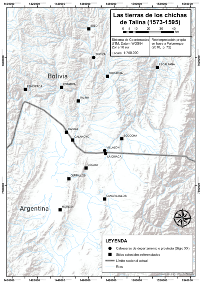
Set against the background of a satellite photograph, this map shows the boundary markers or permanent signs that defined the limits of the Pueblo Real de Indios or Reducción of Talina, with the concentration of a large segment of the Aymara political system of the Chichas starting in 1573.1 This action was part of the reforms implemented by the colonial state in the 1570s that imposed the relocation of dispersed or scattered settlements, in clustered towns. In the case of the Aymara lordship AYMARA POLITIES of THE QULLASUYU in the 16th CENTURY of the Chichas, the dispossession was manifested in the complete rearrangement and restructuring of its territorial organization, and a disarticulation of the original large political entity into a variety of fragmented communities in Reductions, as occurred with Talina THE LANDS OF THE AYMARA LORDSHIP OF THE CHICHAS DE TALINA UNDER COLONIAL RULE IN THE LATE 16TH CENTURY .
The finding of a colonial document has made it possible to identify the approximate location of the boundary markers of the Talina Reduction. The data derived from it was contrasted and cross-checked with the in situ validation of these markers, giving way to the creation of this map, a key piece in the knowledge-acquisition process of this Reduction.2
The document describes that the designated colonial authority (Visitor), starting his rounds from the Indian village of San Juan de la Frontera in the Talina valley, and after visiting the nine villages of the Hatun Chichas area —that is, those in the highland section of the territory—, resolved for those settlements to come together and be concentrated in the Talina valley. There, he distributed land for farming and animal husbandry. The Visitor then proceeded to demarcate the land for each set of family groupings called ayllus*—*which constituted the organizational cell of pre-Hispanic Andean societies—, through precise markings along the territory following the rivers watercourses.
The delimited territory stands along a kind of continuous valley, showing a small elevation forming a circle in its southwestern part, with markings displayed from left to right. Through consultation with different references, in addition to the core document, Palomeque was able to find in a quite truthful way the milestones that indicated the place where the jurisdiction of each of the nine ayllus that made up the Reduction ended.
The map documents some of the names of the ayllus that were concentrated in Talina, as well as the lands and farming plots destined for the elderly, widows, and the poor, as well as those that were common to all. Finally, it shows the importance of the rivers in the delimitation of each space, also referencing the republican towns of Villazón and La Quiaca, in the current demarcation between Argentina and Bolivia.
REFERENCES:
Palomeque, Silvia. “Los Chichas y las visitas Toledanas: las tierras de los Chichas de
Talina (1573-1595).” Surandino Monográfico 1, no. 2 (March 2010): 1-76.