Dispossesions in the Americas

Dispossesions in the Americas

  • Home
  • Explore
  • About
  • Authors
  • Art
  • Bodies
  • Curricula
  • Cultural Heritage
  • Maps
  • Territories
Back to Explore
Map Commentary 1500 - 1599

SPATIAL ORGANIZATION OF THE QULLASUYU UNDER INCA RULE

  • Medeiros, Carmen

  • Grisi, Celina

  • Sánchez Patzy, Radek

Published: 2024

  • Download Image
Platt, T., Bouysse-Cassagne, T., & Harris, O. (2006). Qaraqara-Charka: Mallku, Inka y rey en la Provincia de Charcas (siglos XV – XVII): Historia antropológica de una confederación aymara. Edicion documental y ensayos interpretativos. Con el aliento de Thierry Saignes. Instituto Frances de Estudios Andinos, Plural Editores, Fundacion Cultural del Banco Central de Bolivia, University of St. Andrews.

Platt, T., Bouysse-Cassagne, T., & Harris, O. (2006). Qaraqara-Charka: Mallku, Inka y rey en la Provincia de Charcas (siglos XV – XVII): Historia antropológica de una confederación aymara. Edicion documental y ensayos interpretativos. Con el aliento de Thierry Saignes. Instituto Frances de Estudios Andinos, Plural Editores, Fundacion Cultural del Banco Central de Bolivia, University of St. Andrews.

Abstract

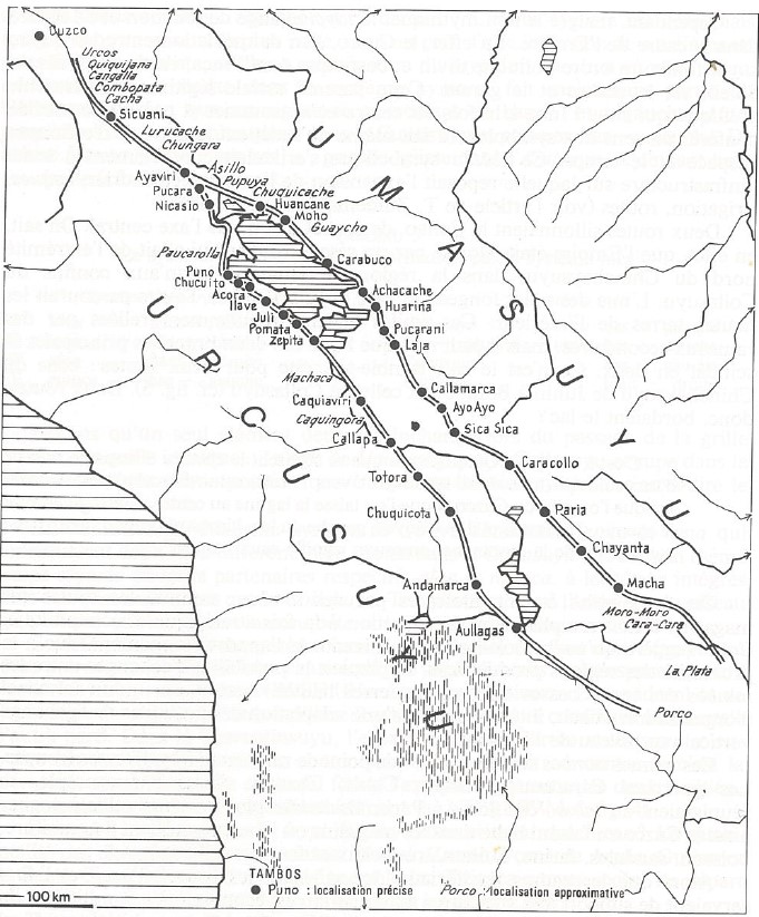
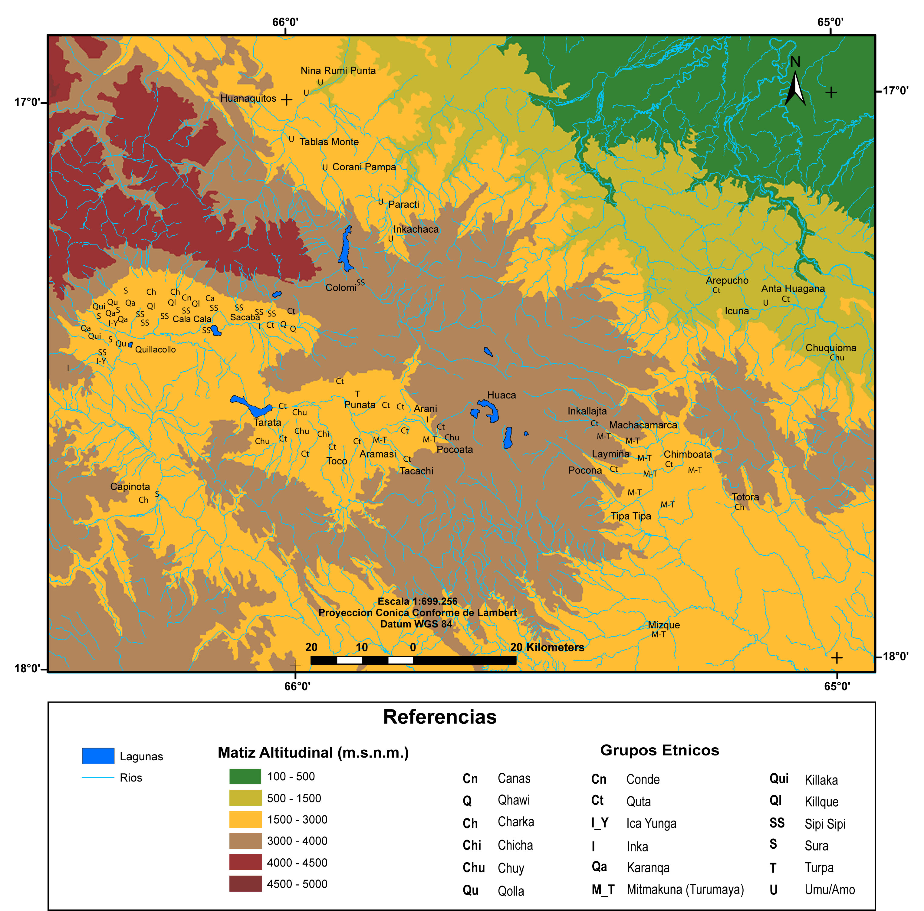
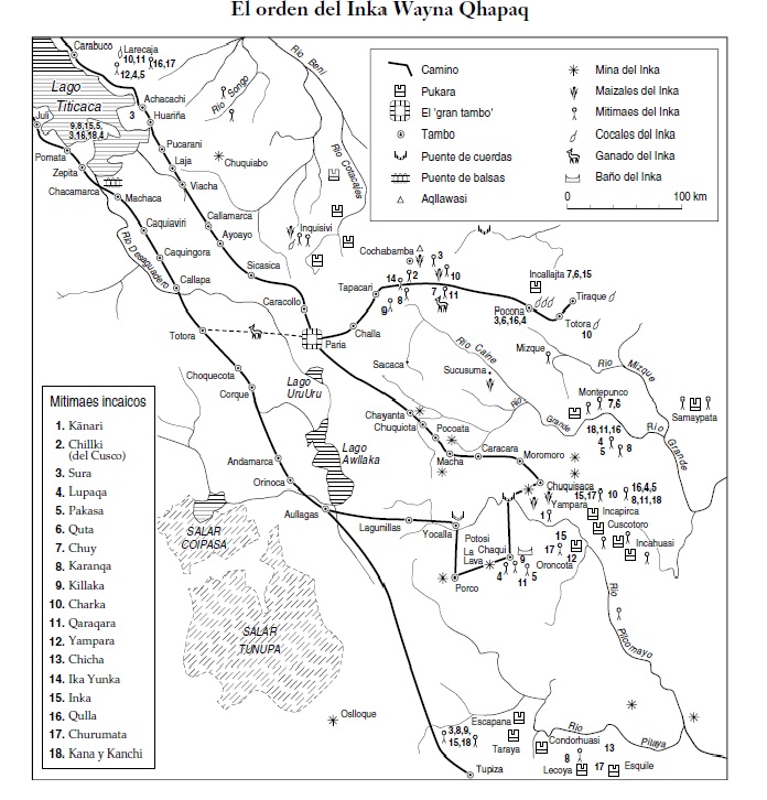
This map illustrates the organization and uses of the space of the southern district of the Inca state also known as the Qullasuyu portraying specifically the high plateau and the eastern inter-Andean valleys, just before the arrival of the Spaniards in the first decades of the 16th century.1 The map indicates: the’Inca Road' INCA ROADS AND TAMBOS in the 16th CENTURY network, the storage centers (or tambos), the bridges, the aqllawasi (specialized institutions in the Inca Empire, essentially “houses of the chosen women’’ who were chosen to carry out specialized tasks in service of the state or the Incas), the Inca mines, the Inca coca and cornfields, the grasslands for the llama herds of the Inca state, and the baths of the Inca. It also shows the multi-ethnic territories MULTI-ETHNIC TERRITORY under INCA DIRECT RULE: THE CENTRAL AND UPPER VALLEYS OF COCHABAMBA in the 1530s , which were areas claimed as domains of the Inca state where the Incas resettled segments of population coming from the different Aymara polities AYMARA POLITIES of THE QULLASUYU in the 16th CENTURY of the Qullasuyu. Lastly, it shows the Pukaras (fortresses) built in Pocona, Samaypata, Cuzcotoro and Oroncota to contain the unconquered peoples, such as the Chiriguanos, and consolidate the territorial expansion of the Inca state, the Tawantinsuyu.

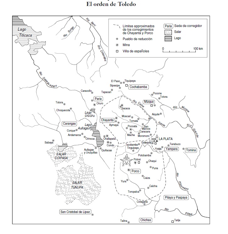
Under Spanish colonial rule, in the late 16th century, the territory of the Qullasuyu became the Audiencia de Charcas following the new political administration of the Viceroyalty of Peru. The spatial organization under colonial rule POLITICAL ORGANIZATION OF SPACE UNDER COLONIAL RULE AT THE END OF THE 16th CENTURY profoundly altered the landscape shown in this map, particularly after the reforms implemented by Viceroy Toledo in the 1570s. Indeed, Toledo launched an ambitious program of massive, forced resettlement of ‘Indians’ into fixed ‘Indian royal towns’ known as reducciones to manage, evangelize, and tax the native population more efficiently. These reforms entailed the disarticulation of the large Aymara polities into fragmented “Indian communities’ and a profound reconfiguration of the organization and management of the space, a reconfiguration that responded to the requirements of the production of silver in the mines of Potosi and other mining centers across the high plateau.

REFERENCES:

Platt, Tristán, Thérèse Bouysse-Cassagne, and Olivia Harris. Qaraqara-Charka: Mallku, Inka y Rey en la Provincia de Charcas (Siglos XV-XVII): Historia Antropológica de una Confederación Aymara. La Paz: PLURAL-IFEA, 2006.


  1. Tristan Platt, Thérèse Bouysse-Cassagne and Olivia Harris, Qaraqara-Charka: Mallku, Inka y Rey en la Provincia de Charcas (Siglos XV-XVII): Historia Antropológica de una Confederación Aymara (La Paz: PLURAL-IFEA, 2006), 82. ↩︎

Citation

Medeiros, Carmen, Celina Grisi, and Radek Sánchez Patzy. 2024. 'SPATIAL ORGANIZATION OF THE QULLASUYU UNDER INCA RULE'. Dispossessions in the Americas. https://dia.upenn.edu/en/content/BOL0008Y/

  • Download Image

Reading in Spanish

Map Commentary 1500 - 1599

ORGANIZACION ESPACIAL DEL QULLASUYU BAJO EL DOMINIO INCAICO

  • Medeiros, Carmen

  • Grisi, Celina

  • Sánchez Patzy, Radek

Published: 2024

  • Download Image
Platt, T., Bouysse-Cassagne, T., & Harris, O. (2006). Qaraqara-Charka: Mallku, Inka y rey en la Provincia de Charcas (siglos XV – XVII): Historia antropológica de una confederación aymara. Edicion documental y ensayos interpretativos. Con el aliento de Thierry Saignes. Instituto Frances de Estudios Andinos, Plural Editores, Fundacion Cultural del Banco Central de Bolivia, University of St. Andrews.

Platt, T., Bouysse-Cassagne, T., & Harris, O. (2006). Qaraqara-Charka: Mallku, Inka y rey en la Provincia de Charcas (siglos XV – XVII): Historia antropológica de una confederación aymara. Edicion documental y ensayos interpretativos. Con el aliento de Thierry Saignes. Instituto Frances de Estudios Andinos, Plural Editores, Fundacion Cultural del Banco Central de Bolivia, University of St. Andrews.

  • Download Image

Reading in Portuguese

Map Commentary 1500 - 1599

ORGANIZAÇÃO ESPACIAL DO QULLASUYU SOB O DOMÍNIO INCAICO

  • Medeiros, Carmen

  • Grisi, Celina

  • Sánchez Patzy, Radek

Published: 2024

  • Download Image
Platt, T., Bouysse-Cassagne, T., & Harris, O. (2006). Qaraqara-Charka: Mallku, Inka y rey en la Provincia de Charcas (siglos XV – XVII): Historia antropológica de una confederación aymara. Edicion documental y ensayos interpretativos. Con el aliento de Thierry Saignes. Instituto Frances de Estudios Andinos, Plural Editores, Fundacion Cultural del Banco Central de Bolivia, University of St. Andrews.

Platt, T., Bouysse-Cassagne, T., & Harris, O. (2006). Qaraqara-Charka: Mallku, Inka y rey en la Provincia de Charcas (siglos XV – XVII): Historia antropológica de una confederación aymara. Edicion documental y ensayos interpretativos. Con el aliento de Thierry Saignes. Instituto Frances de Estudios Andinos, Plural Editores, Fundacion Cultural del Banco Central de Bolivia, University of St. Andrews.

Resumo

Este mapa ilustra a organização e usos do espaço do distrito sul do Estado Inca, também conhecido como o Qullasuyu, e retrata especificamente o altiplano e os vales interandinos orientais pouco antes da chegada dos espanhóis nas primeiras décadas do século XVI.1 O mapa indica a rede Caminhos do Inca CAMINHOS INCAS E TAMBOS NO SÉCULO XVI os centros de armazenamento (ou tambos), as pontes, os aqllawasi (instituições especializadas no Império Inca, essencialmente “casas das mulheres escolhidas” que eram selecionadas para realizar tarefas especializadas a serviço do Estado ou dos incas), as minas incas, os campos de coca e milho incas, as pastagens para os rebanhos de lhamas do Estado Inca, e banheiros do inca. Também mostra os territórios multiétnicos TERRITÓRIO MULTIÉTNICO SOB O DOMÍNIO INCA: OS VALES CENTRAL E ALTO DE COCHABAMBA NA DÉCADA DE 1530 , que eram áreas reivindicadas como domínio do Estado Inca onde os incas reassentaram segmentos da população procedentes das diferentes polis aimarás AS POLÍTICAS AIMARÁS DO QULLASUYU NO SÉCULO XVI do Qullasuyu. Por último, mostra as pukaras (fortalezas) construídas em Pocona, Samaypata, Cuzcotoro e Oroncota para conter os povos não conquistados, como os Chiriguanos, e para consolidar a expansão territorial do Estado Inca, o Tawantinsuyu.

Sob o domínio colonial espanhol, no final do século XVI, o território do Qullasuyu tornou-se a Audiência de Charcas seguindo a nova administração política do Vice-reino do Peru. A organização espacial sob o domínio colonial ORGANIZAÇÃO POLÍTICA DO ESPAÇO SOB O DOMÍNIO COLONIAL NO FINAL DO SÉCULO XVI alterou profundamente a paisagem mostrada neste mapa, particularmente depois das reformas implementadas pelo vice-rei Toledo na década de 1570. De fato, Toledo lançou um ambicioso programa de reassentamento em massa e forçado de “índios” nos “pueblos reales de indios” fixos conhecidos como Reduções para administrar, evangelizar e cobrar impostos da população nativa de maneira mais eficiente. Estas reformas levaram à desarticulação dos grandes estados aimarás em “comunidades de índios” fragmentadas e a uma profunda reconfiguração da organização e gestão do espaço, reconfiguração que respondia aos requerimentos da produção de prata nas minas de Potosí e de outros centros mineradores do altiplano.

BIBLIOGRAFIA:

Platt, Tristán, Thérèse Bouysse-Cassagne e Olivia Harris. Qaraqara-Charka: Mallku, Inka y Rey en la Provincia de Charcas (Siglos XV-XVII): Historia Antropológica de una Confederación Aymara. La Paz: PLURALIFEA, 2006.


  1. Tristan Platt, Thérèse Bouysse-Cassagne e Olivia Harris, Qaraqara-Charka: Mallku, Inka y Rey en la Provincia de Charcas (Siglos XV-XVII): Historia Antropológica de una Confederación Aymara (La Paz: PLURAL-IFEA, 2006), 82. ↩︎

Citation

Medeiros, Carmen, Celina Grisi, and Radek Sánchez Patzy. 2024. 'ORGANIZAÇÃO ESPACIAL DO QULLASUYU SOB O DOMÍNIO INCAICO'. Dispossessions in the Americas. https://dia.upenn.edu/pt/content/BOL0008Y/

  • Download Image

Related Content

INCA ROADS AND TAMBOS in the 16th CENTURY

INCA ROADS AND TAMBOS in the 16th CENTURY

Map Commentary 1500 - 1599
AYMARA POLITIES of THE QULLASUYU in the 16th CENTURY

AYMARA POLITIES of THE QULLASUYU in the 16th CENTURY

Map Commentary 1530 - 1539
THE QULLASUYU IN THE 1530s – SOUTHERN DISTRICT OF THE INCA STATE

THE QULLASUYU IN THE 1530s – SOUTHERN DISTRICT OF THE INCA STATE

Map Commentary 1530 - 1539
MULTI-ETHNIC TERRITORY under INCA DIRECT RULE: THE CENTRAL AND UPPER VALLEYS OF COCHABAMBA in the 1530s

MULTI-ETHNIC TERRITORY under INCA DIRECT RULE: THE CENTRAL AND UPPER VALLEYS OF COCHABAMBA in the 1530s

Map Commentary 1530 - 1539
POLITICAL ORGANIZATION OF SPACE UNDER COLONIAL RULE AT THE END OF THE 16th CENTURY

POLITICAL ORGANIZATION OF SPACE UNDER COLONIAL RULE AT THE END OF THE 16th CENTURY

Map Commentary 1500 - 1599
COLONIAL LEGISLATIONS AS FRAMEWORK FOR DISPOSSESSIONS IN THE CENTRAL ANDES: THE “REDUCCIONES” OR “PUEBLOS REALES DE INDIOS”

COLONIAL LEGISLATIONS AS FRAMEWORK FOR DISPOSSESSIONS IN THE CENTRAL ANDES: THE “REDUCCIONES” OR “PUEBLOS REALES DE INDIOS”

Timeline 1570 - 1749

Dispossessions in the Americas

A project by

University of Pennsylvania

Copyright 2024

With support from

Mellon Foundation

Site design & development

Element 84

Art Credits

Platt, T., Bouysse-Cassagne, T., & Harris, O. (2006). Qaraqara-Charka: Mallku, Inka y rey en la Provincia de Charcas (siglos XV – XVII): Historia antropológica de una confederación aymara. Edicion documental y ensayos interpretativos. Con el aliento de Thierry Saignes. Instituto Frances de Estudios Andinos, Plural Editores, Fundacion Cultural del Banco Central de Bolivia, University of St. Andrews.

Site Pages

  • Home
  • Explore
  • About
  • Authors
  • Art
  • Bodies
  • Curricula
  • Cultural Heritage
  • Maps
  • Territories